Difference between revisions of "2015-05-25 48 9"
From Geohashing
imported>RecentlyChanged (An expedition message sent via Geohash Droid for Android.) |
imported>FippeBot m (Location) |
||
| (13 intermediate revisions by 3 users not shown) | |||
| Line 15: | Line 15: | ||
}} | }} | ||
| − | + | ||
__NOTOC__ | __NOTOC__ | ||
== Location == | == Location == | ||
| − | + | ||
| + | In Oberbrüden near Baknang | ||
== Participants == | == Participants == | ||
| − | + | ||
| − | + | * teamtec, | |
| + | * two friends of him plus one | ||
| + | * girlfriend (of one of the friends) and | ||
| + | * [[User:RecentlyChanged|RecentlyChanged]] | ||
== Plans == | == Plans == | ||
| − | + | We did not really plan, just saw that this would be the nearest reachable geohash and knew that we would have the time to reach it. | |
== Expedition == | == Expedition == | ||
| − | + | *We will be there around 3 pm today. We will have at least one new drag along. -- [[User:RecentlyChanged|RecentlyChanged]] ([[User_talk:RecentlyChanged|talk]]) 11:36, 25 May 2015 (CEST) | |
| + | |||
| + | teamtec just asked his friends without explaining geohashing. "We go to a point." And so we did. | ||
| + | On our way there we had the usual problems one has finding a way you don't know and we even had to try to make it interesting. We started at around 1 pm and arrived at about 4.30 pm. Then we went home almost straight and were back around 6pm. | ||
== Tracklog == | == Tracklog == | ||
| − | + | http://www.everytrail.com/view_trip.php?trip_id=3152294 | |
== Photos == | == Photos == | ||
| Line 38: | Line 45: | ||
--> | --> | ||
<gallery perrow="5"> | <gallery perrow="5"> | ||
| + | |||
| + | Image:2015-05-25_48_9_RecentlyChanged_1432564682000.jpg | The happy hashers! | ||
| + | |||
| + | Image:2015-05-25_48_9_RecentlyChanged_1432564753000.jpg | View to and from the hashpoint (the hash is on the right side, probably a bit further up) | ||
| + | |||
| + | Image:2015-05-25_48_9_RecentlyChanged_1432564671000.jpg | Teamtec together with the 3 drag-alongs. | ||
| + | |||
| + | Image:2015-05-25_48_9_RecentlyChanged_1432564317000.jpg | Proof | ||
</gallery> | </gallery> | ||
| Line 44: | Line 59: | ||
<!-- Add any achievement ribbons you earned below, or remove this section --> | <!-- Add any achievement ribbons you earned below, or remove this section --> | ||
| + | {{land geohash | ||
| + | | latitude = 48 | ||
| + | | longitude = 9 | ||
| + | | date = 2015-05-25 | ||
| + | | name = 5 people | ||
| + | }} | ||
| − | + | {{consecutive geohash 2 | |
| − | + | | count = 2 | |
| − | [[ | + | | latitude = 48 |
| + | | longitude = 8 | ||
| + | | date = 2015-05-24 | ||
| + | | name = [[User:RecentlyChanged|RecentlyChanged]] ([[User_talk:RecentlyChanged|talk]]) | ||
| + | }} | ||
| − | + | {{Minesweeper geohash | |
| + | | graticule = Pforzheim, Germany | ||
| + | | ranknumber = 2 | ||
| + | | n = true | ||
| + | | e = true | ||
| + | | name = [[User:Kleber|teamtec]] | ||
| + | }} | ||
| − | + | {{drag-along | |
| − | + | | latitude = 48 | |
| − | [[ | + | | longitude = 9 |
| − | -- | + | | date = 2015-05-25 |
| + | | partner = 3 people | ||
| + | | name = [[User:Kleber|teamtec]] and [[User:RecentlyChanged|RecentlyChanged]] ([[User_talk:RecentlyChanged|talk]]) | ||
| + | }} | ||
| + | |||
| + | {{Largest Geohash | ||
| + | | latitude = 48 | ||
| + | | longitude = 9 | ||
| + | | date = 2015-05-25 | ||
| + | | number = 5 | ||
| + | | graticule = Stuttgart, Germany | ||
| + | }} | ||
| + | |||
| + | {{Two to the N achievement | ||
| + | | count = 2 | ||
| + | | date = 2015-05-25 | ||
| + | | latitude = 48 | ||
| + | | longitude = 9 | ||
| + | | name = teamtec | ||
| + | | reached = true | ||
| + | }} | ||
| − | |||
[[Category:Expeditions]] | [[Category:Expeditions]] | ||
| − | |||
[[Category:Expeditions with photos]] | [[Category:Expeditions with photos]] | ||
| − | |||
| − | |||
| − | |||
| − | |||
| − | |||
[[Category:Coordinates reached]] | [[Category:Coordinates reached]] | ||
| − | + | {{location|DE|BW|BK}} | |
| − | |||
| − | |||
| − | |||
| − | |||
| − | |||
| − | |||
| − | |||
| − | |||
| − | |||
| − | |||
| − | |||
| − | |||
| − | |||
| − | |||
| − | |||
| − | |||
| − | |||
Latest revision as of 03:46, 15 August 2019
| Mon 25 May 2015 in 48,9: 48.9588443, 9.5133527 geohashing.info google osm bing/os kml crox |
Location
In Oberbrüden near Baknang
Participants
- teamtec,
- two friends of him plus one
- girlfriend (of one of the friends) and
- RecentlyChanged
Plans
We did not really plan, just saw that this would be the nearest reachable geohash and knew that we would have the time to reach it.
Expedition
- We will be there around 3 pm today. We will have at least one new drag along. -- RecentlyChanged (talk) 11:36, 25 May 2015 (CEST)
teamtec just asked his friends without explaining geohashing. "We go to a point." And so we did. On our way there we had the usual problems one has finding a way you don't know and we even had to try to make it interesting. We started at around 1 pm and arrived at about 4.30 pm. Then we went home almost straight and were back around 6pm.
Tracklog
http://www.everytrail.com/view_trip.php?trip_id=3152294
Photos
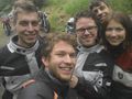
The happy hashers!
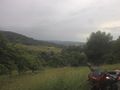
View to and from the hashpoint (the hash is on the right side, probably a bit further up)
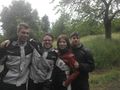
Teamtec together with the 3 drag-alongs.
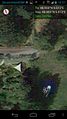
Proof


Achievements
5 people earned the Land geohash achievement
|
RecentlyChanged (talk) earned the Consecutive geohash achievement
|
teamtec achieved level 2 of the Minesweeper Geohash achievement
|
teamtec and RecentlyChanged (talk) earned the Drag-along achievement
|
Stuttgart, Germany earned the Largest geohash achievement
|

teamtec earned the Two to the N achievement
by reaching 22 hashpoints on 2015-05-25 48 9 and is promoted to Level 2 (Coordinates reached).