Difference between revisions of "2015-06-04 52 1"
From Geohashing
imported>Sourcerer m ([live picture] Wheat. [http://www.openstreetmap.org/?lat=52.43689656&lon=1.32585883&zoom=16&layers=B000FTF @52.4369,1.3259]) |
imported>Sourcerer m (→New Expedition) |
||
| Line 19: | Line 19: | ||
== Expedition == | == Expedition == | ||
| + | *Arrived. -- [[User:Sourcerer|Sourcerer]] ([[User talk:Sourcerer|talk]]) [http://www.openstreetmap.org/?lat=52.43691802&lon=1.32585883&zoom=16&layers=B000FTF @52.4369,1.3259] 00:00, 4 June 2015 (GMT+01:00) | ||
| + | There was a convenient parking bay and a kissing gate lead into a grassy meadow. The next field looked like wheat. It was harder than usual to locate the tractor tracks but I eventually succeeded and homed in on the hashpoint at exactly midnight. | ||
| − | |||
| − | |||
== Photos == | == Photos == | ||
<gallery perrow="5"> | <gallery perrow="5"> | ||
| − | |||
| − | |||
Image:2015-06-04_52_1_Sourcerer_1433372389835.jpg | Proof. [http://www.openstreetmap.org/?lat=52.43691802&lon=1.32585883&zoom=16&layers=B000FTF @52.4369,1.3259] | Image:2015-06-04_52_1_Sourcerer_1433372389835.jpg | Proof. [http://www.openstreetmap.org/?lat=52.43691802&lon=1.32585883&zoom=16&layers=B000FTF @52.4369,1.3259] | ||
| − | |||
Image:2015-06-04_52_1_Sourcerer_1433372513239.jpg | Wheat. [http://www.openstreetmap.org/?lat=52.43689656&lon=1.32585883&zoom=16&layers=B000FTF @52.4369,1.3259] | Image:2015-06-04_52_1_Sourcerer_1433372513239.jpg | Wheat. [http://www.openstreetmap.org/?lat=52.43689656&lon=1.32585883&zoom=16&layers=B000FTF @52.4369,1.3259] | ||
</gallery> | </gallery> | ||
| Line 35: | Line 32: | ||
== Achievements == | == Achievements == | ||
{{#vardefine:ribbonwidth|800px}} | {{#vardefine:ribbonwidth|800px}} | ||
| − | + | {{Midnight geohash | |
| + | | latitude = 52 | ||
| + | | longitude = 1 | ||
| + | | date = 2015-06-02 | ||
| + | | name = Sourcerer | ||
| + | }} | ||
| + | {{consecutive geohash 2 | ||
| + | | count = 3 | ||
| + | | latitude = 52 | ||
| + | | longitude = 1 | ||
| + | | date = 2015-06-02 | ||
| + | | name = Sourcerer | ||
| + | }} | ||
== Other geohashing expeditions on the same day == | == Other geohashing expeditions on the same day == | ||
| Line 41: | Line 50: | ||
{{expedition summaries|2015-06-04}} | {{expedition summaries|2015-06-04}} | ||
| − | |||
| − | |||
[[Category:Expeditions]] | [[Category:Expeditions]] | ||
[[Category:Expeditions with photos]] | [[Category:Expeditions with photos]] | ||
[[Category:Coordinates reached]] | [[Category:Coordinates reached]] | ||
| − | |||
Revision as of 23:56, 3 June 2015
| Thu 4 Jun 2015 in 52,1: 52.4368996, 1.3258459 geohashing.info google osm bing/os kml crox |
Location
In a field beside a public footpath, Alburgh Street, Norfolk, UK.
Participants
Plans
Expedition two of two spanning midnight. ETA 00:00 - 2015-06-03 52 1 - 2015-06-04 52 1
Expedition
- Arrived. -- Sourcerer (talk) @52.4369,1.3259 00:00, 4 June 2015 (GMT+01:00)
There was a convenient parking bay and a kissing gate lead into a grassy meadow. The next field looked like wheat. It was harder than usual to locate the tractor tracks but I eventually succeeded and homed in on the hashpoint at exactly midnight.
Photos
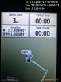
Proof. @52.4369,1.3259
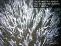
Wheat. @52.4369,1.3259


Achievements
Sourcerer earned the Midnight Geohash achievement
|
Sourcerer earned the Consecutive geohash achievement
|
Other geohashing expeditions on the same day
Expeditions and Plans
| 2015-06-04 | ||
|---|---|---|
| Córdoba, Argentina | Onicofago | In some bushes near a street in Mendiolaza. Córdoba, Argentina. |
| Mannheim, Germany | DODO | On a farm road between Dannstadt and Mutterstadt, next to the Autobahn A61.... |
| Swindon, United Kingdom | Someone went | In the grounds of a school north of Newbury, West Berkshire. |
| Kassel, Germany | GeorgDerReisende | The hash lay on a children's playground in Calden-Westuffeln. |
| Norwich, United Kingdom | Sourcerer | In a field beside a public footpath, Alburgh Street, Norfolk, UK. |