Difference between revisions of "2015-06-05 52 1"
imported>ChromeCrusaders |
imported>FippeBot m (Location) |
||
| (9 intermediate revisions by one other user not shown) | |||
| Line 3: | Line 3: | ||
| lon=1 | | lon=1 | ||
| date=2015-06-05 | | date=2015-06-05 | ||
| + | | graticule_name=Norwich, UK | ||
| + | | graticule_link=Norwich, United Kingdom | ||
}} | }} | ||
__NOTOC__ | __NOTOC__ | ||
| Line 12: | Line 14: | ||
* [[User:ChromeCrusaders|ChromeCrusaders]] - Arrived 17:49 local time. | * [[User:ChromeCrusaders|ChromeCrusaders]] - Arrived 17:49 local time. | ||
| − | * [[User:Sourcerer|Sourcerer]] - | + | * [[User:Sourcerer|Sourcerer]] - Arrived 22:05 local time. |
== Plans == | == Plans == | ||
| Line 20: | Line 22: | ||
== Expedition == | == Expedition == | ||
| + | *Here! -- [[User:ChromeCrusaders|ChromeCrusaders]] ([[User talk:ChromeCrusaders|talk]]) [http://www.openstreetmap.org/?lat=52.39391216&lon=1.68641328&zoom=16&layers=B000FTF @52.3939,1.6864] 12:49, 5 June 2015 (EDT) | ||
| + | It was a little tricky to get too, but we still achieved it! | ||
| − | * | + | * Me too. -- [[User:Sourcerer|Sourcerer]] ([[User talk:Sourcerer|talk]]) [http://www.openstreetmap.org/?lat=52.39387929&lon=1.68637991&zoom=16&layers=B000FTF @52.3939,1.6864] 22:05, 5 June 2015 (GMT+01:00) |
| − | + | In rapidly fading light, I walked along a field perimeter heading roughly west. There was a gate, wide open. The track was most likely used for tending pheasant feeders that looked like baby flying saucers. At the end of the field there was a kink in the path and then a ditch before the woodland. I found a single railway sleeper bridge without any hand rail. This needed good balance to cross. In the wood there was a vague track that lead to mown paths. The hashpoint was a short distance north in the middle of one of these paths. I can confirm that ChromeCrusaders's photo matched the terrain. | |
== Photos == | == Photos == | ||
| Line 31: | Line 35: | ||
Image:Chrome2015-06-05521.jpeg | Stupid Smile (only one participant) | Image:Chrome2015-06-05521.jpeg | Stupid Smile (only one participant) | ||
Image:Chrome2015-06-055212.jpeg | The Surroundings | Image:Chrome2015-06-055212.jpeg | The Surroundings | ||
| + | Image:2015-06-05 52 1 Sourcerer.jpg | Google Earth Tracklog | ||
| + | Image:2015-06-05_52_1_Sourcerer_1433538244357.jpg | Proof. [http://www.openstreetmap.org/?lat=52.39390075&lon=1.68633163&zoom=16&layers=B000FTF @52.3939,1.6863] | ||
| + | Image:2015-06-05_52_1_Sourcerer_1433538823466.jpg | Aliens? [http://www.openstreetmap.org/?lat=52.39294052&lon=1.68880463&zoom=16&layers=B000FTF @52.3929,1.6888] | ||
</gallery> | </gallery> | ||
== Achievements == | == Achievements == | ||
{{#vardefine:ribbonwidth|800px}} | {{#vardefine:ribbonwidth|800px}} | ||
| + | {{OpenStreetMap achievement | ||
| + | | latitude = 52 | ||
| + | | longitude = 1 | ||
| + | | date = 2015-06-05 | ||
| + | | OSMlink = 31809113 | ||
| + | | name = Sourcerer | ||
| + | }} | ||
| − | == | + | {{Sourcerer_links |
| − | + | | prev = 2015-06-04 52 1 | |
| − | + | | curr = 2015-06-05 52 1 | |
| + | | next = 2015-06-09 52 1 | ||
| + | | date = 2015-06-05 | ||
| + | }} | ||
[[Category:Expeditions]] | [[Category:Expeditions]] | ||
[[Category:Expeditions with photos]] | [[Category:Expeditions with photos]] | ||
[[Category:Coordinates reached]] | [[Category:Coordinates reached]] | ||
| + | {{location|GB|ENG|SFK}} | ||
Latest revision as of 11:44, 16 August 2019
| Fri 5 Jun 2015 in Norwich, UK: 52.3938772, 1.6864041 geohashing.info google osm bing/os kml crox |
Location
In a wood in the grounds of Benacre Hall, Benacre, Suffolk, UK.
Participants
- ChromeCrusaders - Arrived 17:49 local time.
- Sourcerer - Arrived 22:05 local time.
Plans
This might be well fenced and private but there might be access via the perimeter of the field next to the wood. It's close enough to home to risk the miles. Sat, Sun and Mon are all in the North Sea - sigh!
Expedition
- Here! -- ChromeCrusaders (talk) @52.3939,1.6864 12:49, 5 June 2015 (EDT)
It was a little tricky to get too, but we still achieved it!
- Me too. -- Sourcerer (talk) @52.3939,1.6864 22:05, 5 June 2015 (GMT+01:00)
In rapidly fading light, I walked along a field perimeter heading roughly west. There was a gate, wide open. The track was most likely used for tending pheasant feeders that looked like baby flying saucers. At the end of the field there was a kink in the path and then a ditch before the woodland. I found a single railway sleeper bridge without any hand rail. This needed good balance to cross. In the wood there was a vague track that lead to mown paths. The hashpoint was a short distance north in the middle of one of these paths. I can confirm that ChromeCrusaders's photo matched the terrain.
Photos
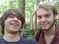
Stupid Smile (only one participant)
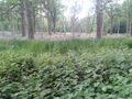
The Surroundings
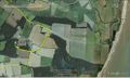
Google Earth Tracklog
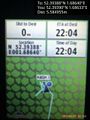
Proof. @52.3939,1.6863
Aliens? @52.3929,1.6888


Achievements
Sourcerer earned the OpenStreetMap achievement
|
Expeditions and Plans
| 2015-06-05 | ||
|---|---|---|
| Portland, Oregon | Shmur | In a forest approximately 1km east of the end of SW Montgomery Way and 100m... |
| Pforzheim, Germany | RecentlyChanged | Near Empfingen |
| Kaiserslautern, Germany | DODO | In the forest above the lake Gelterswoog near Kaiserslautern. |
| Norwich, United Kingdom | ChromeCrusaders, Sourcerer | In a wood in the grounds of Benacre Hall, Benacre, Suffolk, UK. |
| Berlin, Germany | GeorgDerReisende | The hash lay between the forest and the lake Seddinsee in Berlin-Müggelheim... |
| Hannover, Germany | Fippe, GeorgDerReisende | located in the front yard of a building in Hannover-Herrenhausen. |
Sourcerer's Expedition Links
2015-06-04 52 1 - 2015-06-05 52 1 - 2015-06-09 52 1 - KML file download of Sourcerer's expeditions for use with Google Earth.