Difference between revisions of "2015-06-26 51 1"
From Geohashing
imported>Sourcerer m (→Achievement) |
imported>Sourcerer m (→Removed non record breaking consecutive achievements) |
||
| Line 33: | Line 33: | ||
== Achievements == | == Achievements == | ||
{{#vardefine:ribbonwidth|800px}} | {{#vardefine:ribbonwidth|800px}} | ||
| − | |||
| − | |||
| − | |||
| − | |||
| − | |||
| − | |||
| − | |||
| − | |||
{{Sourcerer_links | {{Sourcerer_links | ||
Revision as of 21:48, 18 August 2015
| Fri 26 Jun 2015 in 51,1: 51.9558491, 1.0568826 geohashing.info google osm bing/os kml crox |
Location
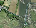
Cattawade Creek, River Stour, Suffolk, UK.
Participants
Plans
An easy point in the Canterbury graticule.
Expedition
- Arrived. -- Sourcerer (talk) @51.9559,1.0569 22:26, 26 June 2015 (GMT+01:00)
The car park by the river was a hive of activity with people queuing at the kebab caravan. Sadly I had bought a shop sandwich so I missed out on the delights of this food stall. The hashpoint was in the car parking area so it was easily reached, as predicted.
Photos
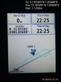
Proof. @51.9559,1.0569
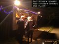
Food stall at the hashpoint. @51.9559,1.0569
Google Earth Track Log


Achievements
Expeditions and Plans
| 2015-06-26 | ||
|---|---|---|
| Buffalo, New York | Pedalpusher | Middle of Mill Rd, East of Jewettville |
| Landshut, Germany | Danatar | in a wheat field between Graßlfing and Untergebraching, both of which are s... |
| Canterbury, United Kingdom | Sourcerer | 2) Cattawade Creek, River Stour, Suffolk, UK. |
| Norwich, United Kingdom | Sourcerer | 1) In a waterfowl wetland at Cley Marshes, Norfolk, UK. |
Sourcerer's Expedition Links
2015-06-26 52 1 - 2015-06-26 51 1 - 2015-06-27 52 0 - KML file download of Sourcerer's expeditions for use with Google Earth.