Difference between revisions of "2015-07-02 52 1"
From Geohashing
imported>Sourcerer m ([live] Arrived.) |
imported>FippeBot m (Location) |
||
| (3 intermediate revisions by one other user not shown) | |||
| Line 3: | Line 3: | ||
| lon=1 | | lon=1 | ||
| date=2015-07-02 | | date=2015-07-02 | ||
| + | | graticule_name=Norwich, UK | ||
| + | | graticule_link=Norwich, United Kingdom | ||
}} | }} | ||
__NOTOC__ | __NOTOC__ | ||
| Line 19: | Line 21: | ||
== Expedition == | == Expedition == | ||
| + | *Arrived. -- [[User:Sourcerer|Sourcerer]] ([[User talk:Sourcerer|talk]]) [http://www.openstreetmap.org/?lat=52.52984047&lon=1.17277980&zoom=16&layers=B000FTF @52.5298,1.1728] 22:02, 2 July 2015 (GMT+01:00) | ||
| + | There was a gated farm access track. The hashpoint was a few metres off the track in a field of carrots. I used tractor tracks and was able to avoid stepping on the crop. Earlier I had added the track to OpenStreetMap. | ||
| − | |||
== Photos == | == Photos == | ||
<gallery perrow="5"> | <gallery perrow="5"> | ||
| + | Image:2015-07-02_52_1_Sourcerer_1435870897245.jpg | Proof. [http://www.openstreetmap.org/?lat=52.52984047&lon=1.17277980&zoom=16&layers=B000FTF @52.5298,1.1728] | ||
| + | Image:2015-07-02 52 1 Sourcerer.jpg | Track log in Google Earth | ||
</gallery> | </gallery> | ||
| Line 44: | Line 49: | ||
}} | }} | ||
| − | |||
| − | |||
[[Category:Expeditions]] | [[Category:Expeditions]] | ||
[[Category:Expeditions with photos]] | [[Category:Expeditions with photos]] | ||
[[Category:Coordinates reached]] | [[Category:Coordinates reached]] | ||
| − | + | {{location|GB|ENG|NFK}} | |
Latest revision as of 04:13, 15 August 2019
| Thu 2 Jul 2015 in Norwich, UK: 52.5298621, 1.1727808 geohashing.info google osm bing/os kml crox |
Location
In a field north of Fundenhall, Norfolk, UK.
Participants
Plans
Expedition one of two spanning midnight - 2015-07-02 52 1 - 2015-07-03 52 1 - ETA 22:30
Expedition
- Arrived. -- Sourcerer (talk) @52.5298,1.1728 22:02, 2 July 2015 (GMT+01:00)
There was a gated farm access track. The hashpoint was a few metres off the track in a field of carrots. I used tractor tracks and was able to avoid stepping on the crop. Earlier I had added the track to OpenStreetMap.
Photos
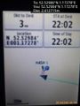
Proof. @52.5298,1.1728
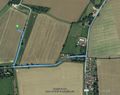
Track log in Google Earth


Achievements
Sourcerer earned the OpenStreetMap achievement
|
Expeditions and Plans
| 2015-07-02 | ||
|---|---|---|
| Montréal, Québec | tavernierdk | located in Lac Saint-Louis, about 1 km off the coast of Île Perrot. |
| Innsbruck, Austria | Juja, Hans, the usual Ninja | About 200 meters away from a forest road between Krün (Finzalm) and Garmisc... |
| Norwich, United Kingdom | Sourcerer | In a field north of Fundenhall, Norfolk, UK. |
| Närpiö, Finland | Pastori, The Wife | In Rösi, Närpiö. The point lies beside the road. |
Sourcerer's Expedition Links
2015-06-30 52 0 - 2015-07-02 52 1 - 2015-07-03 52 1 - KML file download of Sourcerer's expeditions for use with Google Earth.