Difference between revisions of "2015-07-03 52 1"
imported>Sourcerer m (→Planning) |
imported>FippeBot m (Location) |
||
| (8 intermediate revisions by one other user not shown) | |||
| Line 3: | Line 3: | ||
| lon=1 | | lon=1 | ||
| date=2015-07-03 | | date=2015-07-03 | ||
| + | | graticule_name=Norwich, UK | ||
| + | | graticule_link=Norwich, United Kingdom | ||
}} | }} | ||
__NOTOC__ | __NOTOC__ | ||
| Line 19: | Line 21: | ||
== Expedition == | == Expedition == | ||
| + | *Arrived. -- [[User:Sourcerer|Sourcerer]] ([[User talk:Sourcerer|talk]]) [http://www.openstreetmap.org/?lat=52.72851169&lon=1.68669641&zoom=16&layers=B000FTF @52.7285,1.6867] 00:00, 3 July 2015 (GMT+01:00) | ||
| + | |||
| + | The hashpoint was in the sand dunes. I arrived early so a small detour to see the sea was possible. I collected a small bag of sand to make a marker and returned to the hashpoint for an exact midnight announcement to the wiki. Just over two years ago several geohashers visited [[2013-06-02 52 1]], 500 metres from today's point. The weather is set fair so perhaps there will be more trips to the seaside later today. Look for the marker! | ||
== Photos == | == Photos == | ||
<gallery perrow="5"> | <gallery perrow="5"> | ||
| + | Image:2015-07-03_52_1_Sourcerer_1435876398347.jpg | Arrived 26 minutes early. There is warm moonlight so I'll snooze for a bit. [http://www.openstreetmap.org/?lat=52.72852242&lon=1.68669641&zoom=16&layers=B000FTF @52.7285,1.6867] | ||
| + | Image:2015-07-03_52_1_Sourcerer_1435877112832.jpg | Gentle surf. [http://www.openstreetmap.org/?lat=52.72934318&lon=1.68916941&zoom=16&layers=B000FTF @52.7293,1.6892] | ||
| + | Image:2015-07-03_52_1_Sourcerer_1435877947878.jpg | Proof. [http://www.openstreetmap.org/?lat=52.72852242&lon=1.68670714&zoom=16&layers=B000FTF @52.7285,1.6867] | ||
| + | Image:2015-07-03_52_1_Sourcerer_1435877963736.jpg | Sand pile marker. [http://www.openstreetmap.org/?lat=52.72852242&lon=1.68670177&zoom=16&layers=B000FTF @52.7285,1.6867] | ||
| + | Image:2015-07-03 52 1 Sourcerer.jpg | Track log in Google Earth | ||
</gallery> | </gallery> | ||
== Achievements == | == Achievements == | ||
{{#vardefine:ribbonwidth|800px}} | {{#vardefine:ribbonwidth|800px}} | ||
| + | {{Midnight geohash | ||
| + | | latitude = 52 | ||
| + | | longitude = 1 | ||
| + | | date = 2015-07-03 | ||
| + | | name = Sourcerer | ||
| + | }} | ||
{{Sourcerer_links | {{Sourcerer_links | ||
| Line 35: | Line 51: | ||
}} | }} | ||
| − | |||
| − | |||
[[Category:Expeditions]] | [[Category:Expeditions]] | ||
[[Category:Expeditions with photos]] | [[Category:Expeditions with photos]] | ||
[[Category:Coordinates reached]] | [[Category:Coordinates reached]] | ||
| − | + | {{location|GB|ENG|NFK}} | |
Latest revision as of 04:14, 15 August 2019
| Fri 3 Jul 2015 in Norwich, UK: 52.7285320, 1.6867188 geohashing.info google osm bing/os kml crox |
Location
Winterton Dunes, Norfolk, UK.
Participants
Plans
Expedition two of two spanning midnight - 2015-07-02 52 1 - 2015-07-03 52 1 - ETA 00:00
Expedition
- Arrived. -- Sourcerer (talk) @52.7285,1.6867 00:00, 3 July 2015 (GMT+01:00)
The hashpoint was in the sand dunes. I arrived early so a small detour to see the sea was possible. I collected a small bag of sand to make a marker and returned to the hashpoint for an exact midnight announcement to the wiki. Just over two years ago several geohashers visited 2013-06-02 52 1, 500 metres from today's point. The weather is set fair so perhaps there will be more trips to the seaside later today. Look for the marker!
Photos
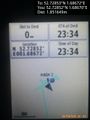
Arrived 26 minutes early. There is warm moonlight so I'll snooze for a bit. @52.7285,1.6867
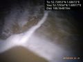
Gentle surf. @52.7293,1.6892
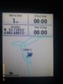
Proof. @52.7285,1.6867
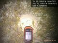
Sand pile marker. @52.7285,1.6867
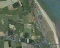
Track log in Google Earth


Achievements
Sourcerer earned the Midnight Geohash achievement
|
Expeditions and Plans
| 2015-07-03 | ||
|---|---|---|
| Buffalo, New York | Pedalpusher | In the woods, in the Town of Aurora |
| Concord, New Hampshire | George, Susanne, Katja, Rebekah | bank of Glove Hollow Brook, Plymouth, NH, USA |
| Norwich, United Kingdom | Sourcerer | Winterton Dunes, Norfolk, UK. |
| Turku, Finland | Pastori, The Wife | Near the house of Nurmela, village of Vistola, commune of Pöytyä. |
Sourcerer's Expedition Links
2015-07-02 52 1 - 2015-07-03 52 1 - 2015-07-04 52 1 - KML file download of Sourcerer's expeditions for use with Google Earth.