Difference between revisions of "2015-07-08 52 1"
imported>Sourcerer m ([live picture] Still here. [http://www.openstreetmap.org/?lat=52.45548427&lon=1.19047701&zoom=16&layers=B000FTF @52.4555,1.1905]) |
imported>Sourcerer m (→New Expedition) |
||
| Line 19: | Line 19: | ||
== Expedition == | == Expedition == | ||
| + | *Arrived early. -- [[User:Sourcerer|Sourcerer]] ([[User talk:Sourcerer|talk]]) [http://www.openstreetmap.org/?lat=52.45548427&lon=1.19051993&zoom=16&layers=B000FTF @52.4555,1.1905] 23:50, 7 July 2015 (GMT+01:00) | ||
| + | There was concrete hard-standing, a useful place to park. The footpath headed west from this, crossing under 400kV supergrid power lines which fizzed with the electrostatic disturbance of the air. This farm was beautifully maintained. The footpaths were mown (not weed-killed) and very easy to follow. Later I headed south, crossing under the power lines again, and reached the magic ten metre distance. There were no further obstructions apart from growing wheat so I chose not to zero my distance. At midnight (23:00 GMT / astronomical time) there was still dim daylight in the northern sky. England is quite close to the north pole really. I could see the great bear and pole star on my return walk. It was 15C with a dry cooling breeze. | ||
| − | |||
| − | |||
== Photos == | == Photos == | ||
<gallery perrow="5"> | <gallery perrow="5"> | ||
| − | |||
| − | |||
Image:2015-07-08_52_1_Sourcerer_1436309500244.jpg | Proof (early). [http://www.openstreetmap.org/?lat=52.45548427&lon=1.19050920&zoom=16&layers=B000FTF @52.4555,1.1905] | Image:2015-07-08_52_1_Sourcerer_1436309500244.jpg | Proof (early). [http://www.openstreetmap.org/?lat=52.45548427&lon=1.19050920&zoom=16&layers=B000FTF @52.4555,1.1905] | ||
| − | |||
Image:2015-07-08_52_1_Sourcerer_1436310005148.jpg | Still here. [http://www.openstreetmap.org/?lat=52.45548427&lon=1.19047701&zoom=16&layers=B000FTF @52.4555,1.1905] | Image:2015-07-08_52_1_Sourcerer_1436310005148.jpg | Still here. [http://www.openstreetmap.org/?lat=52.45548427&lon=1.19047701&zoom=16&layers=B000FTF @52.4555,1.1905] | ||
| + | Image:2015-07-08_52_1_Sourcerer.jpg | Track in Google Earth. | ||
</gallery> | </gallery> | ||
== Achievements == | == Achievements == | ||
{{#vardefine:ribbonwidth|800px}} | {{#vardefine:ribbonwidth|800px}} | ||
| − | |||
{{consecutive geohash 2 | {{consecutive geohash 2 | ||
| count = 7 | | count = 7 | ||
| Line 43: | Line 40: | ||
| name = Sourcerer | | name = Sourcerer | ||
}} | }} | ||
| − | -- | + | {{Midnight geohash |
| + | | latitude = 52 | ||
| + | | longitude = 1 | ||
| + | | date = 2015-07-08 | ||
| + | | name = Sourcerer | ||
| + | }} | ||
| + | |||
{{Sourcerer_links | {{Sourcerer_links | ||
| prev = 2015-07-07 52 1 | | prev = 2015-07-07 52 1 | ||
| Line 51: | Line 54: | ||
}} | }} | ||
| − | + | ||
| − | |||
[[Category:Expeditions]] | [[Category:Expeditions]] | ||
[[Category:Expeditions with photos]] | [[Category:Expeditions with photos]] | ||
[[Category:Coordinates reached]] | [[Category:Coordinates reached]] | ||
| − | |||
Revision as of 00:34, 8 July 2015
| Wed 8 Jul 2015 in 52,1: 52.4554961, 1.1906588 geohashing.info google osm bing/os kml crox |
Location
Close to a public footpath south of Great Moulton, Norfolk, UK.
Participants
Plans
Expedition two of two spanning midnight - 2015-07-07 52 1 - 2015-07-08 52 1 - ETA 00:00.
Expedition
- Arrived early. -- Sourcerer (talk) @52.4555,1.1905 23:50, 7 July 2015 (GMT+01:00)
There was concrete hard-standing, a useful place to park. The footpath headed west from this, crossing under 400kV supergrid power lines which fizzed with the electrostatic disturbance of the air. This farm was beautifully maintained. The footpaths were mown (not weed-killed) and very easy to follow. Later I headed south, crossing under the power lines again, and reached the magic ten metre distance. There were no further obstructions apart from growing wheat so I chose not to zero my distance. At midnight (23:00 GMT / astronomical time) there was still dim daylight in the northern sky. England is quite close to the north pole really. I could see the great bear and pole star on my return walk. It was 15C with a dry cooling breeze.
Photos
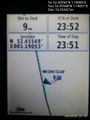
Proof (early). @52.4555,1.1905
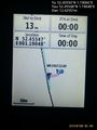
Still here. @52.4555,1.1905
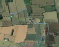
Track in Google Earth.


Achievements
Sourcerer earned the Consecutive geohash achievement
|
Sourcerer earned the Midnight Geohash achievement
|
Expeditions and Plans
| 2015-07-08 | ||
|---|---|---|
| McMinnville, Oregon | Jim | Ag land off Bald Peak Road |
| München, Germany | Juja, Hans | Not even 100 meters from a road near Aichach, Bavaria. |
| Norwich, United Kingdom | Sourcerer | Close to a public footpath south of Great Moulton, Norfolk, UK. |
Sourcerer's Expedition Links
2015-07-07 52 1 - 2015-07-08 52 1 - 2015-07-09 52 1 - KML file download of Sourcerer's expeditions for use with Google Earth.