Difference between revisions of "2015-07-13 52 1"
imported>Sourcerer m (→Planning) |
imported>FippeBot m (Location) |
||
| (12 intermediate revisions by one other user not shown) | |||
| Line 3: | Line 3: | ||
| lon=1 | | lon=1 | ||
| date=2015-07-13 | | date=2015-07-13 | ||
| + | | graticule_name=Norwich, UK | ||
| + | | graticule_link=Norwich, United Kingdom | ||
}} | }} | ||
__NOTOC__ | __NOTOC__ | ||
| Line 17: | Line 19: | ||
Expedition one of two spanning midnight - [[2015-07-13 52 1]] - [[2015-07-14 52 1]] - ETA 22:05. | Expedition one of two spanning midnight - [[2015-07-13 52 1]] - [[2015-07-14 52 1]] - ETA 22:05. | ||
| − | == Expedition == | + | == Expedition - Fail == |
There have been four days of marine hashpoints. Now at last there's a land geohash. | There have been four days of marine hashpoints. Now at last there's a land geohash. | ||
| + | |||
| + | *Fail. -- [[User:Sourcerer|Sourcerer]] ([[User talk:Sourcerer|talk]]) [http://www.openstreetmap.org/?lat=52.09939957&lon=1.07852161&zoom=16&layers=B000FTF @52.0994,1.0785] 22:34, 13 July 2015 (GMT+01:00) | ||
| + | |||
| + | I found the access road easily but it had changed. Google earth showed a horticultural supplies warehouse. In real life it looked like an up-market farm with security systems and attack dogs. I didn't like the look of that route. | ||
| + | |||
| + | It was cloudy and damp. There was no moon. The city lights were far away. So it was darker than usual. A short backtrack led to a public footpath and a safe parking place. I followed this in roughly the right direction. Sadly it led back to the fancy farm. Before I abandoned my attempt, I spotted my first ever real live badger with the distinctive black and white pointed nose. I have only ever seen roadkill before. Then I followed tractor tracks in a barley field, trying to get closer. I spotted a dot of light like a lit L.E.D. This seemed improbable in the middle of a barley field. I tool a photo which came out as a one pixel dot on a black background. Then I had a closer look with a torch. There was a [https://en.wikipedia.org/wiki/Lampyris_noctiluca glow-worm (Lampyris_noctiluca)] sitting on a stalk close to the ground with its light emitting bum pointing upwards. The torch didn't disturb it and it continued to glow steadily. I believe these are extremely rare. | ||
| + | |||
| + | So I failed to reach the hashpoint. I wet my trouser legs by wading through the damp barley. I got covered in clay mud. And I got two lifetime firsts, wildlife spotting. Result! | ||
== Photos == | == Photos == | ||
<gallery perrow="5"> | <gallery perrow="5"> | ||
| + | Image:2015-07-13_52_1_Sourcerer_1436823109211.jpg | Fail. [http://www.openstreetmap.org/?lat=52.09941566&lon=1.07850552&zoom=16&layers=B000FTF @52.0994,1.0785] | ||
| + | Image:2015-07-13_52_1_Sourcerer_1436823170709.jpg | Gardens. [http://www.openstreetmap.org/?lat=52.09941566&lon=1.07850552&zoom=16&layers=B000FTF @52.0994,1.0785] | ||
| + | Image:2015-07-13_52_1_Sourcerer_1436821973634.jpg | Glow Worm! [http://www.openstreetmap.org/?lat=52.09939957&lon=1.07852161&zoom=16&layers=B000FTF @52.0994,1.0785] | ||
| + | Image:2015-07-13 52 1 Sourcerer.jpg | Track in Google Earth | ||
</gallery> | </gallery> | ||
| Line 45: | Line 59: | ||
| − | |||
| − | |||
[[Category:Expeditions]] | [[Category:Expeditions]] | ||
[[Category:Expeditions with photos]] | [[Category:Expeditions with photos]] | ||
| − | [[Category:Coordinates reached]] | + | [[Category:Coordinates not reached]] |
| − | - | + | [[Category:Not reached - No public access]] |
| + | {{location|GB|ENG|SFK}} | ||
Latest revision as of 04:21, 15 August 2019
| Mon 13 Jul 2015 in Norwich, UK: 52.1072906, 1.0731050 geohashing.info google osm bing/os kml crox |
Location
In woodland or perhaps a quarry, Clay Pit Grove, north of Little Blakenham, Suffolk, UK.
Participants
Plans
Expedition one of two spanning midnight - 2015-07-13 52 1 - 2015-07-14 52 1 - ETA 22:05.
Expedition - Fail
There have been four days of marine hashpoints. Now at last there's a land geohash.
- Fail. -- Sourcerer (talk) @52.0994,1.0785 22:34, 13 July 2015 (GMT+01:00)
I found the access road easily but it had changed. Google earth showed a horticultural supplies warehouse. In real life it looked like an up-market farm with security systems and attack dogs. I didn't like the look of that route.
It was cloudy and damp. There was no moon. The city lights were far away. So it was darker than usual. A short backtrack led to a public footpath and a safe parking place. I followed this in roughly the right direction. Sadly it led back to the fancy farm. Before I abandoned my attempt, I spotted my first ever real live badger with the distinctive black and white pointed nose. I have only ever seen roadkill before. Then I followed tractor tracks in a barley field, trying to get closer. I spotted a dot of light like a lit L.E.D. This seemed improbable in the middle of a barley field. I tool a photo which came out as a one pixel dot on a black background. Then I had a closer look with a torch. There was a glow-worm (Lampyris_noctiluca) sitting on a stalk close to the ground with its light emitting bum pointing upwards. The torch didn't disturb it and it continued to glow steadily. I believe these are extremely rare.
So I failed to reach the hashpoint. I wet my trouser legs by wading through the damp barley. I got covered in clay mud. And I got two lifetime firsts, wildlife spotting. Result!
Photos
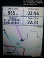
Fail. @52.0994,1.0785
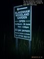
Gardens. @52.0994,1.0785
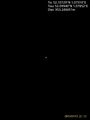
Glow Worm! @52.0994,1.0785
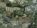
Track in Google Earth


Achievements
Sourcerer earned the OpenStreetMap achievement
|
Expeditions and Plans
| 2015-07-13 | ||
|---|---|---|
| Upper Hutt, New Zealand | Quaternary | Totara Park, Upper Hutt, New Zealand |
| München, Germany | TheOneRing | next to a street right at the exit of Türkenfeld. |
| Cambridge, United Kingdom | Benjw | In a wheat field between Foxton and Fowlmere, south of Cambridge. |
| Norwich, United Kingdom | Sourcerer | In woodland or perhaps a quarry, Clay Pit Grove, north of Little Blakenham,... |
Sourcerer's Expedition Links
2015-07-08 52 1 - 2015-07-13 52 1 - 2015-07-14 52 1 - KML file download of Sourcerer's expeditions for use with Google Earth.