Difference between revisions of "2015-07-19 52 1"
From Geohashing
imported>Sourcerer m (→New Expedition) |
imported>FippeBot m (Location) |
||
| (One intermediate revision by one other user not shown) | |||
| Line 3: | Line 3: | ||
| lon=1 | | lon=1 | ||
| date=2015-07-19 | | date=2015-07-19 | ||
| + | | graticule_name=Norwich, UK | ||
| + | | graticule_link=Norwich, United Kingdom | ||
}} | }} | ||
__NOTOC__ | __NOTOC__ | ||
| Line 41: | Line 43: | ||
[[Category:Expeditions with photos]] | [[Category:Expeditions with photos]] | ||
[[Category:Coordinates reached]] | [[Category:Coordinates reached]] | ||
| + | {{location|GB|ENG|NFK}} | ||
Latest revision as of 04:24, 15 August 2019
| Sun 19 Jul 2015 in Norwich, UK: 52.4417786, 1.2674051 geohashing.info google osm bing/os kml crox |
Location
In a field between Harleston and Long Stratton, Norfolk, UK.
Participants
Plans
Expedition one of two spanning midnight - 2015-07-19 52 1 - 2015-07-20 52 0 - ETA 23:20.
Expedition
- Arrived. -- Sourcerer (talk) @52.4418,1.2674 23:09, 19 July 2015 (GMT+01:00)
This was easy. There was a dry place to park at the field entrance. There were obvious tractor tracks. The second set of tracks led right to the hashpoint.
Photos
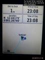
Proof. @52.4418,1.2674
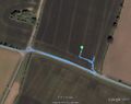
Track in Google Earth


Expeditions and Plans
| 2015-07-19 | ||
|---|---|---|
| Innsbruck, Austria | TheOneRing | in the city of Mittenwald. |
| Norwich, United Kingdom | Sourcerer | In a field between Harleston and Long Stratton, Norfolk, UK. |
Sourcerer's Expedition Links
2015-07-17 52 1 - 2015-07-19 52 1 - 2015-07-20 52 0 - KML file download of Sourcerer's expeditions for use with Google Earth.