Difference between revisions of "2015-07-21 52 1"
From Geohashing
imported>Sourcerer m ([live] Arrived.) |
imported>Sourcerer m ([live picture] Proof [http://www.openstreetmap.org/?lat=52.76055336&lon=1.54818177&zoom=16&layers=B000FTF @52.7606,1.5482]) |
||
| Line 26: | Line 26: | ||
<gallery perrow="5"> | <gallery perrow="5"> | ||
| + | |||
| + | Image:2015-07-21_52_1_Sourcerer_1437514907159.jpg | Proof [http://www.openstreetmap.org/?lat=52.76055336&lon=1.54818177&zoom=16&layers=B000FTF @52.7606,1.5482] | ||
</gallery> | </gallery> | ||
Revision as of 21:42, 21 July 2015
| Tue 21 Jul 2015 in 52,1: 52.7605390, 1.5481940 geohashing.info google osm bing/os kml crox |
Location
In a field between Sutton and Hickling Green, Norfolk, UK.
Participants
Plans
Expedition one of two spanning midnight - 2015-07-21 52 1 - 2015-07-22 52 1 - ETA 23:00
Expedition
This is 200 metres from my Sutton Corn Mill expedition at 2010-11-07 52 1 and 100 metres from a public footpath.
- Arrived. -- Sourcerer (talk) @52.7605,1.5482 22:40, 21 July 2015 (GMT+01:00)
Photos
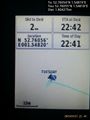
Proof @52.7606,1.5482

Achievements
Expeditions and Plans
| 2015-07-21 | ||
|---|---|---|
| Christchurch, New Zealand | Quaternary | Greenpark Huts, Canterbury, New Zealand |
| Boise, Idaho | Eldin, Eldin's dad | On a sidewalk in a residential neighborhood in Nampa. |
| Portland, Oregon | Jim, Michael5000, Frogman | A school yard in Portland |
| Kaposvár, Hungary | Someone went | Somewhere |
| Szombathely, Hungary | Micsnare, Patrizius, Crankl, B2c | Next to a small access road at the Austrian-Hungarian border near Klingenba... |
| Mannheim, Germany | tads | On a field between Gernsheim and Bickenbach, close to the A67. |
| Norwich, United Kingdom | Sourcerer | In a field between Sutton and Hickling Green, Norfolk, UK. |
| Nykøbing Falster, Denmark | Q-Owl, Q-Owla | In Denmark on the island Lolland, graticule Nykøbing Falster. |
| Nilsiä, Finland | Pastori, The Wife | In Murtomäki, Valtimo. The point lies in a swamp. |
| Globalhash | Micsnare, Patrizius, Crankl, B2c | The hashers planned to meet at the hashcave around 4:30pm as the whole trip... |
Sourcerer's Expedition Links
2015-07-20 52 0 - 2015-07-21 52 1 - 2015-07-22 52 1 - KML file download of Sourcerer's expeditions for use with Google Earth.