Difference between revisions of "2015-07-27 52 0"
imported>Sourcerer m (→Link corrected) |
imported>Sourcerer m (→Removed non record breaking consecutive achievements) |
||
| Line 37: | Line 37: | ||
| longitude = 0 | | longitude = 0 | ||
| date = 2015-07-27 | | date = 2015-07-27 | ||
| − | |||
| − | |||
| − | |||
| − | |||
| − | |||
| − | |||
| − | |||
| name = Sourcerer | | name = Sourcerer | ||
}} | }} | ||
Revision as of 21:53, 18 August 2015
| Mon 27 Jul 2015 in 52,0: 52.8278308, 0.9195462 geohashing.info google osm bing/os kml crox |
Location
In a field a few metres off a track, South east of Fakenham, Norfolk, UK.
Participants
Plans
Expedition two of two spanning midnight - 2015-07-26 51 1 - 2015-07-27 52 0 - ETA 00:00
Expedition
- Arrived. -- Sourcerer (talk) @52.8278,.9195 00:15, 27 July 2015 (GMT+01:00)
The hashpoint was in a partly harvested barley field, possibly organic because there were no tractor tracks from crop spraying. It was tipping down with rain and the crop and rolls of straw were getting soaked. The weather is forecast to improve next month so perhaps not too much damage will have been done. Luckily the hashpoint was in the harvested area. I arrived a little late having made a detour to get fuel.
Photos
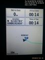
Proof. @52.8278,.9195
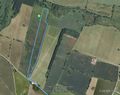
Track in Google Earth


Achievements
Sourcerer earned the Midnight Geohash achievement
|
Expeditions and Plans
| 2015-07-27 | ||
|---|---|---|
| Grand Rapids, Michigan | Mcbaneg, Katja | field behind an irrigation business, Zeeland, MI, USA |
| Mannheim, Germany | tads | located on a field in Otzberg-Zipfen. |
| Cambridge, United Kingdom | Sourcerer | In a field a few metres off a track, South east of Fakenham, Norfolk, UK. |
| Kajaani, Finland | Nebini | In Puolanka, a few hundred meters from the road. |
Sourcerer's Expedition Links
2015-07-26 51 1 - 2015-07-27 52 0 - 2015-07-28 52 1 - KML file download of Sourcerer's expeditions for use with Google Earth.