Difference between revisions of "2015-08-04 51 1"
From Geohashing
imported>Sourcerer m (→Achievements) |
imported>FippeBot m (Location) |
||
| (2 intermediate revisions by one other user not shown) | |||
| Line 3: | Line 3: | ||
| lon=1 | | lon=1 | ||
| date=2015-08-04 | | date=2015-08-04 | ||
| + | | graticule_name=Canterbury, UK | ||
| + | | graticule_link=Canterbury, United Kingdom | ||
}} | }} | ||
__NOTOC__ | __NOTOC__ | ||
| − | |||
== Location == | == Location == | ||
| Line 33: | Line 34: | ||
== Achievements == | == Achievements == | ||
{{#vardefine:ribbonwidth|700px}} | {{#vardefine:ribbonwidth|700px}} | ||
| − | |||
| − | |||
| − | |||
| − | |||
| − | |||
| − | |||
| − | |||
{{Sourcerer_links | {{Sourcerer_links | ||
| Line 51: | Line 45: | ||
[[Category:Expeditions with photos]] | [[Category:Expeditions with photos]] | ||
[[Category:Coordinates reached]] | [[Category:Coordinates reached]] | ||
| + | {{location|GB|ENG|ESS}} | ||
Latest revision as of 04:40, 15 August 2019
| Tue 4 Aug 2015 in Canterbury, UK: 51.9503150, 1.0122907 geohashing.info google osm bing/os kml crox |
Location
Close to a lane south west of Flatford Mill (famous haywain painting), Dedham, Essex, UK.
Participants
Plans
Expedition one of two spanning midnight - 2015-08-04 51 1 - 2015-08-05 52 1 - ETA 22:35.
Expedition
- Arrived. -- Sourcerer (talk) @51.9503,1.0124 22:31, 4 August 2015 (GMT+01:00)
This was not the most exciting expedition. Crossing the river Stour in Dedham was interesting (in the dark). The actual destination was a featureless country lane next to a wheat field. I was 10 metres from the hashpoint in the car. I got stung by nettles to get to the edge of the wheat with 6 metres to go. I didn't bother to zero the distance.
Photos
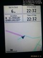
Proof. @51.9503,1.0124
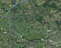
Track in Google Earth


Achievements
Expeditions and Plans
| 2015-08-04 | ||
|---|---|---|
| Würzburg, Germany | Tads | in a forest close to Babenhausen (Hessen) |
| Canterbury, United Kingdom | Sourcerer | Close to a lane south west of Flatford Mill (famous haywain painting), Dedh... |
Sourcerer's Expedition Links
2015-08-02 52 0 - 2015-08-04 51 1 - 2015-08-05 52 1 - KML file download of Sourcerer's expeditions for use with Google Earth.