Difference between revisions of "2015-08-27 52 1"
From Geohashing
imported>Sourcerer m ([live picture] Proof [http://www.openstreetmap.org/?lat=52.53808558&lon=1.45104825&zoom=16&layers=B000FTF @52.5381,1.4510]) |
imported>Sourcerer m (→New expedition) |
||
| Line 19: | Line 19: | ||
== Expedition == | == Expedition == | ||
| + | *Arrived. -- [[User:Sourcerer|Sourcerer]] ([[User talk:Sourcerer|talk]]) [http://www.openstreetmap.org/?lat=52.53808558&lon=1.45104825&zoom=16&layers=B000FTF @52.5381,1.4510] 22:46, 27 August 2015 (GMT+01:00) | ||
| + | This was easy enough, 10km from home. In bright moon light I crossed some stubble to reach the hashpoint in a field. | ||
| − | |||
| − | |||
| − | |||
== Photos == | == Photos == | ||
<gallery perrow="5"> | <gallery perrow="5"> | ||
| − | |||
Image:2015-08-27_52_1_Sourcerer_1440711922647.jpg | Proof [http://www.openstreetmap.org/?lat=52.53808558&lon=1.45104825&zoom=16&layers=B000FTF @52.5381,1.4510] | Image:2015-08-27_52_1_Sourcerer_1440711922647.jpg | Proof [http://www.openstreetmap.org/?lat=52.53808558&lon=1.45104825&zoom=16&layers=B000FTF @52.5381,1.4510] | ||
| + | Image:2015-08-27 52 1 Sourcerer.jpg | Track in Google Earth | ||
</gallery> | </gallery> | ||
| Line 41: | Line 40: | ||
}} | }} | ||
| − | |||
| − | |||
| − | |||
[[Category:Expeditions]] | [[Category:Expeditions]] | ||
[[Category:Expeditions with photos]] | [[Category:Expeditions with photos]] | ||
[[Category:Coordinates reached]] | [[Category:Coordinates reached]] | ||
| − | |||
Revision as of 00:45, 28 August 2015
| Thu 27 Aug 2015 in 52,1: 52.5380765, 1.4510463 geohashing.info google osm bing/os kml crox |
Location
In a field at Sisland, west of Loddon, Norfolk, UK.
Participants
Plans
Expedition one of two spanning midnight - 2015-08-27 52 1 - 2015-08-28 52 1 - ETA 23:00.
Expedition
- Arrived. -- Sourcerer (talk) @52.5381,1.4510 22:46, 27 August 2015 (GMT+01:00)
This was easy enough, 10km from home. In bright moon light I crossed some stubble to reach the hashpoint in a field.
Photos
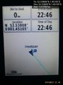
Proof @52.5381,1.4510
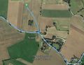
Track in Google Earth


Achievements
Expeditions and Plans
| 2015-08-27 | ||
|---|---|---|
| Portland, Oregon | zhukant, TachiTaylor, Jim | On the edge of the Old Barn restaurant in Tigard. |
| Ljubljana, Slovenia | B2c | In a field near St. Margarethen im Rosental, in the south of Carinthia. |
| Norwich, United Kingdom | Sourcerer | In a field at Sisland, west of Loddon, Norfolk, UK. |
Sourcerer's Expedition Links
2015-08-26 52 0 - 2015-08-27 52 1 - 2015-08-28 52 1 - KML file download of Sourcerer's expeditions for use with Google Earth.