Difference between revisions of "2015-11-30 52 1"
From Geohashing
imported>Sourcerer m ([live] Arrived.) |
imported>FippeBot m (Location) |
||
| (3 intermediate revisions by one other user not shown) | |||
| Line 3: | Line 3: | ||
| lon=1 | | lon=1 | ||
| date=2015-11-30 | | date=2015-11-30 | ||
| + | | graticule_name=Norwich, UK | ||
| + | | graticule_link=Norwich, United Kingdom | ||
}} | }} | ||
__NOTOC__ | __NOTOC__ | ||
| Line 16: | Line 18: | ||
== Plans == | == Plans == | ||
| − | Expedition | + | Expedition three of three spanning midnight - [[2015-11-29 52 1]] - [[2015-01-25 52 1 | 2015-01-25 52 1 Retro]] - [[2015-11-30 52 1]] - ETA 00:00. |
== Expedition == | == Expedition == | ||
| + | *Arrived. -- [[User:Sourcerer|Sourcerer]] ([[User talk:Sourcerer|talk]]) [http://www.openstreetmap.org/?lat=52.75912642&lon=1.46264076&zoom=16&layers=B000FTF @52.7591,1.4626] 00:00, 30 November 2015 (GMT) | ||
| + | The field entrance was good for parking. I took the evidence photo just before midnight and posted the "arrived" message on the dot. This was a stubble field with easily followed tractor tracks. This was a more sheltered location and much less chilly than the previous two expeditions. | ||
| − | |||
| − | |||
== Photos == | == Photos == | ||
<gallery> | <gallery> | ||
| − | |||
Image:2015-11-30_52_1_Sourcerer_1448841499388.jpg | Proof. [http://www.openstreetmap.org/?lat=52.75912106&lon=1.46264076&zoom=16&layers=B000FTF @52.7591,1.4626] | Image:2015-11-30_52_1_Sourcerer_1448841499388.jpg | Proof. [http://www.openstreetmap.org/?lat=52.75912106&lon=1.46264076&zoom=16&layers=B000FTF @52.7591,1.4626] | ||
| + | Image:2015-11-30_52_1_Sourcerer.jpg | Google Earth Track | ||
</gallery> | </gallery> | ||
== Achievements == | == Achievements == | ||
{{#vardefine:ribbonwidth|700px}} | {{#vardefine:ribbonwidth|700px}} | ||
| + | |||
| + | {{Midnight geohash | ||
| + | | latitude = 52 | ||
| + | | longitude = 1 | ||
| + | | date = 2015-11-30 | ||
| + | | name = Sourcerer | ||
| + | }} | ||
{{Sourcerer_links | {{Sourcerer_links | ||
| Line 40: | Line 49: | ||
}} | }} | ||
| − | |||
| − | |||
[[Category:Expeditions]] | [[Category:Expeditions]] | ||
[[Category:Expeditions with photos]] | [[Category:Expeditions with photos]] | ||
[[Category:Coordinates reached]] | [[Category:Coordinates reached]] | ||
| − | + | {{location|GB|ENG|NFK}} | |
Latest revision as of 06:01, 15 August 2019
| Mon 30 Nov 2015 in Norwich, UK: 52.7591672, 1.4626307 geohashing.info google osm bing/os kml crox |
Location
In a field south east of Smallburgh, Norfolk, UK.
Participants
Plans
Expedition three of three spanning midnight - 2015-11-29 52 1 - 2015-01-25 52 1 Retro - 2015-11-30 52 1 - ETA 00:00.
Expedition
- Arrived. -- Sourcerer (talk) @52.7591,1.4626 00:00, 30 November 2015 (GMT)
The field entrance was good for parking. I took the evidence photo just before midnight and posted the "arrived" message on the dot. This was a stubble field with easily followed tractor tracks. This was a more sheltered location and much less chilly than the previous two expeditions.
Photos
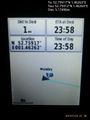
Proof. @52.7591,1.4626
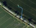
Google Earth Track


Achievements
Sourcerer earned the Midnight Geohash achievement
|
Expeditions and Plans
| 2015-11-30 | ||
|---|---|---|
| Cambridge, United Kingdom | PaintedJaguar, MrsPaintedJaguar | Next to the ruins of St James Church, on the outskirts of King's Lynn. |
| Norwich, United Kingdom | Sourcerer | In a field south east of Smallburgh, Norfolk, UK. |
| Nilsiä, Finland | Pastori, The Wife | In Rumo, Valtimo. The 100th successful hashpoint! The point lies in an area... |
Sourcerer's Expedition Links
2015-11-29 52 1 - 2015-11-30 52 1 - 2015-12-01 52 1 - KML file download of Sourcerer's expeditions for use with Google Earth.