Difference between revisions of "2015-12-05 46 15"
imported>GeoEdo (→Achievements) |
m (per Renaming Proposal) |
||
| (14 intermediate revisions by 2 users not shown) | |||
| Line 16: | Line 16: | ||
== Expedition == | == Expedition == | ||
| + | When I saw the location of this geohash on Friday when weekend hashpoints were published I knew I just had to go there. The hashpoint is almost on the road and in another country, so win-win-win situation. And when GeoWife and GeoKids agreed to join me on my expedition the situation became even better - win-win-win-win-win... As an added bonus I knew I'll get tons of ribbons for this. | ||
| + | We started our expedition at about 11:00. We first went on A3 motorway and at Jankomir junction we changed to A2, and it drove us to our first international border: Croatia-Slovenia border. In Slovenia we proceeded at A4 motorway till Slivnica junction and there we changed to A1 motorway that drove us to our next international border: Slovenia-Austria border. In Austria we continued our way on A9 motorway. At Leibnitz we went down from the motorway and local roads took us almost straight to the hashpoint. | ||
| − | + | The haspoint is just a meter or two off the road in the Wagnastrasse, so I missed Speed racer achievement for really, really small distance. After dancing around the ground zero, the best reading I got is about 3.4 meters, but I'm more than reasonably certain that there were no obstacles between me and the uncertainty bubble of this geohash. So, happy dance could begin. | |
| + | This expedition earned me nice set of ribbons: this was virgin graticule, and now it's deflowered; I crossed not one, but two international borders to reach this geohash; I traveled more than 160 km to reach it (173 km); I dragged not one, but three non-hashers; I achieved level 2 both for the Minesweeper and for the Two to the N achievement (coordinates reached). | ||
| + | As additional bonus I think that all three non-hashers dragged to this expedition started to grasp what it's all about. After we finished our expedition, older GeoKid asked: "So, why we came here?", and GeoWife answered quite correctly: "So that dad can stand next to shrubs and say he was here." | ||
| − | == | + | == Tracklog == |
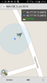
| + | <gallery> | ||
| + | Image:2015-12-05 46-15 tracklog.jpg|Expedition tracklog | ||
| + | </gallery> | ||
| + | [http://www.wikiloc.com/wikiloc/view.do?id=11582286 Expedition tracklog on Wikiloc] | ||
| + | |||
| + | == Photos == | ||
| + | <gallery perrow="5"> | ||
| + | Image:20151205 124149.jpg|Croatia-Slovenia border | ||
| + | Image:20151205 133753.jpg|Slovenia-Austria border | ||
| + | Image:20151205 140039.jpg|Expedition team near hashpoint | ||
| + | Image:Screenshot 2015-12-05-14-02-35.png|Proof of correct location | ||
| + | Image:Screenshot 2015-12-05-14-02-46.png|Proof of correct date | ||
| + | Image:20151205 140307.jpg|Hashpoint | ||
| + | Image:20151205 140311.jpg|Hashmobile from hashpoint | ||
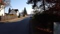
| + | Image:20151205 140340.jpg|Wagnastrasse near hashpoint | ||
| + | </gallery> | ||
== Achievements == | == Achievements == | ||
| Line 31: | Line 51: | ||
| graticule = Zagreb East, Croatia | | graticule = Zagreb East, Croatia | ||
| ranknumber = 2 | | ranknumber = 2 | ||
| − | | nw = true | + | | nw = true |
| − | | n = true | + | | n = true |
| name = GeoEdo | | name = GeoEdo | ||
}} | }} | ||
| + | |||
| + | {{Two to the N achievement|count=2|date=2015-12-05|latitude=46|longitude=15|reached=true}} | ||
{{xkcd-100 | {{xkcd-100 | ||
| Line 50: | Line 72: | ||
| longitude = 15 | | longitude = 15 | ||
| date = 2015-12-05 | | date = 2015-12-05 | ||
| + | | name = GeoEdo | ||
| + | }} | ||
| + | {{drag-along | ||
| + | | latitude = 46 | ||
| + | | longitude = 15 | ||
| + | | date = 2015-12-05 | ||
| + | | partner = GeoWife & GeoKids | ||
| name = GeoEdo | | name = GeoEdo | ||
}} | }} | ||
| − | {{ | + | {{Graticule unlocked |
| latitude = 46 | | latitude = 46 | ||
| longitude = 15 | | longitude = 15 | ||
| Line 73: | Line 102: | ||
[[Category:Expeditions with photos]] | [[Category:Expeditions with photos]] | ||
[[Category:Coordinates reached]] | [[Category:Coordinates reached]] | ||
| + | {{location|AT|ST|LB}} | ||
Latest revision as of 05:01, 20 March 2024
| Sat 5 Dec 2015 in 46,15: 46.7713588, 15.5476825 geohashing.info google osm bing/os kml crox |
Location
Just meter or two off the road in the Wagnastrasse in Leibnitz, Austria.
Participants
- GeoEdo
- GeoWife
- GeoKids
Expedition
When I saw the location of this geohash on Friday when weekend hashpoints were published I knew I just had to go there. The hashpoint is almost on the road and in another country, so win-win-win situation. And when GeoWife and GeoKids agreed to join me on my expedition the situation became even better - win-win-win-win-win... As an added bonus I knew I'll get tons of ribbons for this.
We started our expedition at about 11:00. We first went on A3 motorway and at Jankomir junction we changed to A2, and it drove us to our first international border: Croatia-Slovenia border. In Slovenia we proceeded at A4 motorway till Slivnica junction and there we changed to A1 motorway that drove us to our next international border: Slovenia-Austria border. In Austria we continued our way on A9 motorway. At Leibnitz we went down from the motorway and local roads took us almost straight to the hashpoint.
The haspoint is just a meter or two off the road in the Wagnastrasse, so I missed Speed racer achievement for really, really small distance. After dancing around the ground zero, the best reading I got is about 3.4 meters, but I'm more than reasonably certain that there were no obstacles between me and the uncertainty bubble of this geohash. So, happy dance could begin.
This expedition earned me nice set of ribbons: this was virgin graticule, and now it's deflowered; I crossed not one, but two international borders to reach this geohash; I traveled more than 160 km to reach it (173 km); I dragged not one, but three non-hashers; I achieved level 2 both for the Minesweeper and for the Two to the N achievement (coordinates reached).
As additional bonus I think that all three non-hashers dragged to this expedition started to grasp what it's all about. After we finished our expedition, older GeoKid asked: "So, why we came here?", and GeoWife answered quite correctly: "So that dad can stand next to shrubs and say he was here."
Tracklog
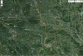
Expedition tracklog

Expedition tracklog on Wikiloc
Photos
Croatia-Slovenia border
Slovenia-Austria border
Expedition team near hashpoint
Proof of correct location
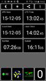
Proof of correct date
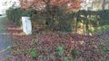
Hashpoint
Hashmobile from hashpoint
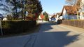
Wagnastrasse near hashpoint


Achievements
GeoEdo achieved level 2 of the Minesweeper Geohash achievement
|

GeoEdo earned the XKCD-100 Achievement
|
GeoEdo earned the Border geohash achievement
|
GeoEdo earned the Drag-along achievement
|
GeoEdo earned the Graticule Unlocked Achievement
|
GeoEdo earned the Land geohash achievement
|