Difference between revisions of "2015-12-16 52 1"
imported>Sourcerer (→Planning) |
m |
||
| (9 intermediate revisions by 2 users not shown) | |||
| Line 10: | Line 10: | ||
== Location == | == Location == | ||
| − | In a field between Westleton and Dunwich Heaths close to the Minsmere bird reserve, Suffolk, UK | + | 2) In a field between Westleton and Dunwich Heaths close to the Minsmere bird reserve, Suffolk, UK. |
== Participants == | == Participants == | ||
| Line 18: | Line 18: | ||
== Plans == | == Plans == | ||
| + | Expedition one of four spanning midnight, | ||
| + | [[2015-12-16 52 1]] - [[2015-08-25 52 1|2015-08-25 52 1 Retro]] - [[2010-09-12 52 1|2010-09-12 52 1 Retro]] - [[2015-12-17 52 1]] - ETA 23:00. | ||
| − | == Expedition == | + | == Expedition fail == |
| + | Five metres from the point there was a sturdy fence. There was no way to climb over without damage so it's coordinates not reached. 220 metres away was a handy retrohash. This was in a meadow with broken down fences so it was accessible. This field was full of deep holes. It could have been rabbits but they had been really busy. Badgers would normally want more cover. The retro was easily reached. | ||
== Photos == | == Photos == | ||
<gallery> | <gallery> | ||
| + | Image:2015-12-16 52 1 Sourcerer Proof.jpg | Proof. | ||
| + | Image:2015-12-16 52 1 Sourcerer.jpg | Google Earth Track. | ||
</gallery> | </gallery> | ||
| Line 37: | Line 42: | ||
}} | }} | ||
| − | |||
| − | |||
[[Category:Expeditions]] | [[Category:Expeditions]] | ||
[[Category:Expeditions with photos]] | [[Category:Expeditions with photos]] | ||
| − | [[Category:Coordinates reached]] | + | [[Category:Coordinates not reached]] |
| − | - | + | [[Category:Not reached - No public access]] |
| + | {{location|GB|ENG|SFK}} | ||
Latest revision as of 09:20, 28 March 2022
| Wed 16 Dec 2015 in Norwich, UK: 52.2672401, 1.6171747 geohashing.info google osm bing/os kml crox |
Location
2) In a field between Westleton and Dunwich Heaths close to the Minsmere bird reserve, Suffolk, UK.
Participants
Plans
Expedition one of four spanning midnight,
2015-12-16 52 1 - 2015-08-25 52 1 Retro - 2010-09-12 52 1 Retro - 2015-12-17 52 1 - ETA 23:00.
Expedition fail
Five metres from the point there was a sturdy fence. There was no way to climb over without damage so it's coordinates not reached. 220 metres away was a handy retrohash. This was in a meadow with broken down fences so it was accessible. This field was full of deep holes. It could have been rabbits but they had been really busy. Badgers would normally want more cover. The retro was easily reached.
Photos
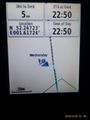
Proof.
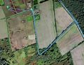
Google Earth Track.


Achievements
Expeditions and Plans
| 2015-12-16 | ||
|---|---|---|
| Mannheim, Germany | DODO | On (or next to) a road in Rot. Very close to 2015-08-25 49 8. |
| London West, United Kingdom | Benjw, His friend, who lives in Guildford, was | Next to a tree on Holly Lane, NW of Guildford, Surrey. |
| Cambridge, United Kingdom | Sourcerer | 1) In a field, a few yards off a public footpath, north of the A14 and west... |
| Norwich, United Kingdom | Sourcerer | 2) In a field between Westleton and Dunwich Heaths close to the Minsmere bi... |
Sourcerer's Expedition Links
2015-12-16 52 0 - 2015-12-16 52 1 - 2015-12-17 52 1 - KML file download of Sourcerer's expeditions for use with Google Earth.