Difference between revisions of "2015-12-17 52 1"
From Geohashing
imported>Sourcerer m (→Planning) |
imported>FippeBot m (Location) |
||
| (8 intermediate revisions by one other user not shown) | |||
| Line 10: | Line 10: | ||
== Location == | == Location == | ||
| − | A road hashpoint on the B1123 west of Halesworth, Suffolk, UK. | + | 1) A road hashpoint on the B1123 west of Halesworth, Suffolk, UK. |
== Participants == | == Participants == | ||
| Line 18: | Line 18: | ||
== Plans == | == Plans == | ||
| − | Expedition | + | Expedition four of four spanning midnight, |
| + | |||
| + | [[2015-12-16 52 1]] - [[2015-08-25 52 1|2015-08-25 52 1 Retro]] - [[2010-09-12 52 1|2010-09-12 52 1 Retro]] - [[2015-12-17 52 1]] - ETA 00:00. | ||
== Expedition == | == Expedition == | ||
| + | *Arrived. -- [[User:Sourcerer|Sourcerer]] ([[User talk:Sourcerer|talk]]) [http://www.openstreetmap.org/?lat=52.34416723&lon=1.46319866&zoom=16&layers=B000FTF @52.3442,1.4632] 00:00, 17 December 2015 (GMT) | ||
| + | |||
| + | There was no need to get out of the car for this well timed road hashpoint. | ||
== Photos == | == Photos == | ||
<gallery> | <gallery> | ||
| + | Image:2015-12-17_52_1_Sourcerer_1450310355699.jpg | Proof. [http://www.openstreetmap.org/?lat=52.34416723&lon=1.46319866&zoom=16&layers=B000FTF @52.3442,1.4632] | ||
| + | Image:2015-12-17 52 1 Sourcerer.jpg | Google Earth Track | ||
</gallery> | </gallery> | ||
| Line 40: | Line 47: | ||
| prev = 2015-12-16 52 1 | | prev = 2015-12-16 52 1 | ||
| curr = 2015-12-17 52 1 | | curr = 2015-12-17 52 1 | ||
| − | | next = 2015-12- | + | | next = 2015-12-17 52 0 |
| date = 2015-12-17 | | date = 2015-12-17 | ||
}} | }} | ||
| − | + | ||
| − | |||
[[Category:Expeditions]] | [[Category:Expeditions]] | ||
[[Category:Expeditions with photos]] | [[Category:Expeditions with photos]] | ||
[[Category:Coordinates reached]] | [[Category:Coordinates reached]] | ||
| − | + | {{location|GB|ENG|SFK}} | |
Latest revision as of 11:45, 16 August 2019
| Thu 17 Dec 2015 in Norwich, UK: 52.3441408, 1.4632205 geohashing.info google osm bing/os kml crox |
Location
1) A road hashpoint on the B1123 west of Halesworth, Suffolk, UK.
Participants
Plans
Expedition four of four spanning midnight,
2015-12-16 52 1 - 2015-08-25 52 1 Retro - 2010-09-12 52 1 Retro - 2015-12-17 52 1 - ETA 00:00.
Expedition
- Arrived. -- Sourcerer (talk) @52.3442,1.4632 00:00, 17 December 2015 (GMT)
There was no need to get out of the car for this well timed road hashpoint.
Photos
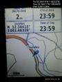
Proof. @52.3442,1.4632
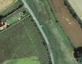
Google Earth Track


Achievements
Sourcerer earned the Midnight Geohash achievement
|
Expeditions and Plans
| 2015-12-17 | ||
|---|---|---|
| Springfield, Illinois | Mystrsyko, Dolphintreasure | A field just off Veterans Parkway in Springfield. |
| Grand Rapids, Michigan | Mcbaneg | Next to a public path, Byron Center, MI |
| Mannheim, Germany | DODO | On a lawn next to a lake in Speyer. |
| Kassel, Germany | GeorgDerReisende | The hash lay in the Sandweg in Kassel-Jungfernkopf. |
| Cambridge, United Kingdom | Sourcerer | 2) In a field, south of West Row, south of the Mildenhall air base, Suffolk... |
| Norwich, United Kingdom | Sourcerer | 1) A road hashpoint on the B1123 west of Halesworth, Suffolk, UK. |
| Braunschweig, Germany | Someone went | Somewhere |
Sourcerer's Expedition Links
2015-12-16 52 1 - 2015-12-17 52 1 - 2015-12-17 52 0 - KML file download of Sourcerer's expeditions for use with Google Earth.