Difference between revisions of "2015-12-27 52 1"
From Geohashing
imported>Sourcerer m ([live picture] Proof with lat and lon. [http://www.openstreetmap.org/?lat=52.32223749&lon=1.44347370&zoom=16&layers=B000FTF @52.3222,1.4435]) |
imported>FippeBot m (Location) |
||
| (2 intermediate revisions by one other user not shown) | |||
| Line 21: | Line 21: | ||
== Expedition == | == Expedition == | ||
| − | + | This was nice. There was good moonlight and although the ground was wet, it was a mild dry night (12.5 C). There was space to park at the start of the footpath. Closer to the hashpoint, tractor tracks led roughly the right way through winter wheat. The next tracks, parallel led closer so there was some doubling back. | |
== Photos == | == Photos == | ||
<gallery> | <gallery> | ||
| − | |||
Image:2015-12-27_52_1_Sourcerer_1451250100696.jpg | Arrival proof. [http://www.openstreetmap.org/?lat=52.32225358&lon=1.44348979&zoom=16&layers=B000FTF @52.3223,1.4435] | Image:2015-12-27_52_1_Sourcerer_1451250100696.jpg | Arrival proof. [http://www.openstreetmap.org/?lat=52.32225358&lon=1.44348979&zoom=16&layers=B000FTF @52.3223,1.4435] | ||
| − | |||
Image:2015-12-27_52_1_Sourcerer_1451250388497.jpg | Proof with lat and lon. [http://www.openstreetmap.org/?lat=52.32223749&lon=1.44347370&zoom=16&layers=B000FTF @52.3222,1.4435] | Image:2015-12-27_52_1_Sourcerer_1451250388497.jpg | Proof with lat and lon. [http://www.openstreetmap.org/?lat=52.32223749&lon=1.44347370&zoom=16&layers=B000FTF @52.3222,1.4435] | ||
| + | Image:2015-12-27_52_1_Sourcerer.jpg | Google Earth Track. | ||
</gallery> | </gallery> | ||
| Line 37: | Line 36: | ||
| prev = 2015-12-27 52 0 | | prev = 2015-12-27 52 0 | ||
| curr = 2015-12-27 52 1 | | curr = 2015-12-27 52 1 | ||
| − | | next = 2015-12-28 52 | + | | next = 2015-12-28 52 0 |
| date = 2015-12-27 | | date = 2015-12-27 | ||
}} | }} | ||
| Line 44: | Line 43: | ||
[[Category:Expeditions with photos]] | [[Category:Expeditions with photos]] | ||
[[Category:Coordinates reached]] | [[Category:Coordinates reached]] | ||
| + | {{location|GB|ENG|SFK}} | ||
Latest revision as of 06:16, 15 August 2019
| Sun 27 Dec 2015 in Norwich, UK: 52.3222562, 1.4434902 geohashing.info google osm bing/os kml crox |
Location
3) In a field, south of Cookley, Suffolk, UK.
Participants
Plans
Three of three today 2015-12-27 52 -0 - 2015-12-27 52 0 - 2015-12-27 52 1
Expedition
This was nice. There was good moonlight and although the ground was wet, it was a mild dry night (12.5 C). There was space to park at the start of the footpath. Closer to the hashpoint, tractor tracks led roughly the right way through winter wheat. The next tracks, parallel led closer so there was some doubling back.
Photos
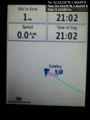
Arrival proof. @52.3223,1.4435
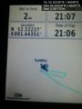
Proof with lat and lon. @52.3222,1.4435
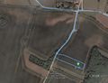
Google Earth Track.


Achievements
Expeditions and Plans
| 2015-12-27 | ||
|---|---|---|
| Mannheim, Germany | DODO | In the road Hinterm Esel (Behind the donkey) in Speyer. |
| Kassel, Germany | GeorgDerReisende | The hash lay on the cemetery of Kassel-Kirchditmold. |
| Northampton, United Kingdom | Sourcerer | 1) In a field east of Covington, Cambridgeshire, UK. |
| Cambridge, United Kingdom | Sourcerer | 2) In a paddock at Freckenham, Suffolk, UK. This is probably private. |
| Norwich, United Kingdom | Sourcerer | 3) In a field, south of Cookley, Suffolk, UK. |
| Sheffield, United Kingdom | Danheller | In some woods, near an organic farm that we'd been to in the autumn for an ... |
Sourcerer's Expedition Links
2015-12-27 52 0 - 2015-12-27 52 1 - 2015-12-28 52 0 - KML file download of Sourcerer's expeditions for use with Google Earth.