Difference between revisions of "2015-12-31 52 0"
imported>Sourcerer (→Planning) |
imported>FippeBot m (Location) |
||
| (7 intermediate revisions by one other user not shown) | |||
| Line 9: | Line 9: | ||
== Location == | == Location == | ||
| − | In a field west of the A1101 from Littleport to Mildenhall, Suffolk, UK. | + | 2) In a field west of the A1101 from Littleport to Mildenhall, Suffolk, UK. |
== Participants == | == Participants == | ||
| Line 17: | Line 17: | ||
== Plans == | == Plans == | ||
| − | + | Expedition two of three spanning the new year midnight. | |
| + | |||
| + | [[2015-12-31 52 1]] - [[2015-12-31 52 0]] - [[2016-01-01 52 0]] - ETA 22:40. | ||
== Expedition == | == Expedition == | ||
| + | This was my last hashpoint for 2015. There was a place to park in the entrance to a vegetable packing plant. A short walk along the main road led close to the hashpoint. This was fen land with deep drainage ditches everywhere, so access was predicted to be difficult. In fact it could hardly have been easier. The expected ditch was not there. It was a simple scramble down the road embankment into the field. The tractor tracks were easy to see and led to within 5 metres. This took less time than expected and I was 18 minutes early. | ||
| + | == Photos == | ||
| − | |||
<gallery> | <gallery> | ||
| + | Image:2015-12-31_52_0_Sourcerer_1451600534539.jpg | Arrival proof. [http://www.openstreetmap.org/?lat=52.41395831&lon=.42433619&zoom=16&layers=B000FTF @52.4140,.4243] | ||
| + | Image:2015-12-31_52_0_Sourcerer.jpg | Google Earth Track | ||
</gallery> | </gallery> | ||
| Line 33: | Line 38: | ||
| prev = 2015-12-31 52 1 | | prev = 2015-12-31 52 1 | ||
| curr = 2015-12-31 52 0 | | curr = 2015-12-31 52 0 | ||
| − | | next = 2016- | + | | next = 2016-01-01 52 0 |
| date = 2015-12-31 | | date = 2015-12-31 | ||
}} | }} | ||
| − | |||
| − | |||
[[Category:Expeditions]] | [[Category:Expeditions]] | ||
[[Category:Expeditions with photos]] | [[Category:Expeditions with photos]] | ||
[[Category:Coordinates reached]] | [[Category:Coordinates reached]] | ||
| − | + | {{location|GB|ENG|SFK}} | |
Latest revision as of 06:20, 15 August 2019
| Thu 31 Dec 2015 in Cambridge, UK: 52.4139590, 0.4243446 geohashing.info google osm bing/os kml crox |
Location
2) In a field west of the A1101 from Littleport to Mildenhall, Suffolk, UK.
Participants
Plans
Expedition two of three spanning the new year midnight.
2015-12-31 52 1 - 2015-12-31 52 0 - 2016-01-01 52 0 - ETA 22:40.
Expedition
This was my last hashpoint for 2015. There was a place to park in the entrance to a vegetable packing plant. A short walk along the main road led close to the hashpoint. This was fen land with deep drainage ditches everywhere, so access was predicted to be difficult. In fact it could hardly have been easier. The expected ditch was not there. It was a simple scramble down the road embankment into the field. The tractor tracks were easy to see and led to within 5 metres. This took less time than expected and I was 18 minutes early.
Photos
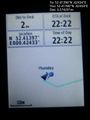
Arrival proof. @52.4140,.4243
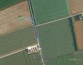
Google Earth Track


Achievements
Expeditions and Plans
| 2015-12-31 | ||
|---|---|---|
| Albury Wodonga, Australia | Felix Dance, Stevage, Tom | In a field next to the Ovens River, near Wangaratta in Victoria's North. |
| Seattle, Washington | Benjamin Kaiser, Andrew Leach, Andrew Williamson | On the sidewalk across from a housing complex (a group of buildings/apartme... |
| Mannheim, Germany | DODO | In a wet grassland south of Neuhofen. |
| Cambridge, United Kingdom | Sourcerer | 2) In a field west of the A1101 from Littleport to Mildenhall, Suffolk, UK.... |
| Norwich, United Kingdom | Sourcerer | 1) In a field close to a footpath between St. Margaret South-Elmham and Ilk... |
| Sheffield, United Kingdom | Chadders66 | An alleyway behind a Nisa store in Wincobank, near the Meadowhall Interchan... |
Sourcerer's Expedition Links
2015-12-31 52 1 - 2015-12-31 52 0 - 2016-01-01 52 0 - KML file download of Sourcerer's expeditions for use with Google Earth.