Difference between revisions of "2016-01-04 51 1"
imported>Sourcerer m (→Planning) |
imported>FippeBot m (Location) |
||
| (3 intermediate revisions by one other user not shown) | |||
| Line 9: | Line 9: | ||
== Location == | == Location == | ||
| − | + | 3) In a field, south of Wrabness and the river Stour, Suffolk, UK. | |
== Participants == | == Participants == | ||
| Line 21: | Line 21: | ||
== Expedition == | == Expedition == | ||
| − | + | 20 minutes behind schedule, after a soggy walk through fields of wet mud, the stupidity distance began. The final field had been freshly ploughed and the surface was very uneven. Slow wobbly progress led to the hashpoint. Large cakes of clay soil built up under my footwear (sandals). The official footpath had not been clearly marked and my track deviated from the official route. The weather was still, 5C, star light. | |
== Photos == | == Photos == | ||
<gallery> | <gallery> | ||
| + | Image:2016-01-04_51_1_Sourcerer_1451949538890.jpg | Arrival proof. [http://www.openstreetmap.org/?lat=51.90739095&lon=1.15543127&zoom=16&layers=B000FTF @51.9074,1.1554] | ||
| + | Image:2016-01-04_51_1_Sourcerer.jpg | Google Earth Track | ||
</gallery> | </gallery> | ||
| Line 37: | Line 39: | ||
}} | }} | ||
| − | |||
| − | |||
[[Category:Expeditions]] | [[Category:Expeditions]] | ||
[[Category:Expeditions with photos]] | [[Category:Expeditions with photos]] | ||
[[Category:Coordinates reached]] | [[Category:Coordinates reached]] | ||
| − | + | {{location|GB|ENG|ESS}} | |
Latest revision as of 06:24, 15 August 2019
| Mon 4 Jan 2016 in Canterbury, UK: 51.9073868, 1.1554141 geohashing.info google osm bing/os kml crox |
Location
3) In a field, south of Wrabness and the river Stour, Suffolk, UK.
Participants
Plans
Expedition three of four spanning midnight - 2015-11-08 52 1 Retro - 2016-01-04 52 1 - 2016-01-04 51 1 - 2016-01-05 52 0 - ETA 23:00.
Expedition
20 minutes behind schedule, after a soggy walk through fields of wet mud, the stupidity distance began. The final field had been freshly ploughed and the surface was very uneven. Slow wobbly progress led to the hashpoint. Large cakes of clay soil built up under my footwear (sandals). The official footpath had not been clearly marked and my track deviated from the official route. The weather was still, 5C, star light.
Photos
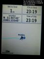
Arrival proof. @51.9074,1.1554
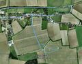
Google Earth Track


Achievements
Expeditions and Plans
| 2016-01-04 | ||
|---|---|---|
| Nürnberg, Germany | Klaus | field close to the borders of Hohenpölz |
| Bonn, Germany | Burgman | A small path in Rösrath. |
| Canterbury, United Kingdom | Sourcerer | 3) In a field, south of Wrabness and the river Stour, Suffolk, UK. |
| Norwich, United Kingdom | Sourcerer | 2) In a field west of Bodham close and All Saints Church, Norfolk, UK. |
Sourcerer's Expedition Links
2016-01-04 52 1 - 2016-01-04 51 1 - 2016-01-05 52 0 - KML file download of Sourcerer's expeditions for use with Google Earth.