Difference between revisions of "2016-01-09 52 1"
From Geohashing
imported>Sourcerer m ([live] Arrived.) |
imported>FippeBot m (Location) |
||
| (2 intermediate revisions by one other user not shown) | |||
| Line 21: | Line 21: | ||
== Expedition == | == Expedition == | ||
| + | *Arrived. -- [[User:Sourcerer|Sourcerer]] ([[User talk:Sourcerer|talk]]) [http://www.openstreetmap.org/?lat=52.78230608&lon=1.02117598&zoom=16&layers=B000FTF @52.7823,1.0212] 00:00, 9 January 2016 (GMT) | ||
| + | There was a damp parking place in the field entrance. A temporary stream of clear water was flowing along the roadside. The hashpoint was in the field of small oil seed rape plants. | ||
| − | |||
| − | |||
== Photos == | == Photos == | ||
<gallery perrow=4> | <gallery perrow=4> | ||
| − | |||
Image:2016-01-09_52_1_Sourcerer_1452297396828.jpg | Proof. [http://www.openstreetmap.org/?lat=52.78231144&lon=1.02116525&zoom=16&layers=B000FTF @52.7823,1.0212] | Image:2016-01-09_52_1_Sourcerer_1452297396828.jpg | Proof. [http://www.openstreetmap.org/?lat=52.78231144&lon=1.02116525&zoom=16&layers=B000FTF @52.7823,1.0212] | ||
| + | Image:2016-01-09_52_1_Sourcerer.jpg | Google Earth Track | ||
</gallery> | </gallery> | ||
== Achievements == | == Achievements == | ||
{{#vardefine:ribbonwidth|700px}} | {{#vardefine:ribbonwidth|700px}} | ||
| + | |||
| + | {{Midnight geohash | ||
| + | | latitude = 52 | ||
| + | | longitude = 1 | ||
| + | | date = 2016-01-09 | ||
| + | | name = Sourcerer | ||
| + | }} | ||
{{Sourcerer_links | {{Sourcerer_links | ||
| Line 41: | Line 48: | ||
}} | }} | ||
| − | |||
| − | |||
[[Category:Expeditions]] | [[Category:Expeditions]] | ||
[[Category:Expeditions with photos]] | [[Category:Expeditions with photos]] | ||
[[Category:Coordinates reached]] | [[Category:Coordinates reached]] | ||
| − | + | {{location|GB|ENG|NFK}} | |
Latest revision as of 06:26, 15 August 2019
| Sat 9 Jan 2016 in Norwich, UK: 52.7823047, 1.0211839 geohashing.info google osm bing/os kml crox |
Location
2) A field east of Foulsham, Norfolk, UK.
Participants
Plans
2 of 2 spanning midnight - 2016-01-08 52 1 - 2016-01-09 52 1 - ETA 00:00.
Expedition
- Arrived. -- Sourcerer (talk) @52.7823,1.0212 00:00, 9 January 2016 (GMT)
There was a damp parking place in the field entrance. A temporary stream of clear water was flowing along the roadside. The hashpoint was in the field of small oil seed rape plants.
Photos
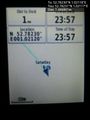
Proof. @52.7823,1.0212
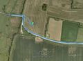
Google Earth Track


Achievements
Sourcerer earned the Midnight Geohash achievement
|
Expeditions and Plans
| 2016-01-09 | ||
|---|---|---|
| Melbourne East, Australia | Dave | In a residential block in the suburb of Alphington |
| Newark, New Jersey | OtherJack | A very busy sidewalk in a South American neighborhood in Union City, New Je... |
| Norwich, United Kingdom | Sourcerer | 2) A field east of Foulsham, Norfolk, UK. |
Sourcerer's Expedition Links
2016-01-08 52 1 - 2016-01-09 52 1 - 2016-01-10 52 1 - KML file download of Sourcerer's expeditions for use with Google Earth.