Difference between revisions of "2016-01-11 52 1"
imported>Sourcerer m (→Achievements) |
imported>FippeBot m (Location) |
||
| (2 intermediate revisions by one other user not shown) | |||
| Line 21: | Line 21: | ||
== Expedition == | == Expedition == | ||
| − | + | This was a well timed midnight arrival at the 256<sup>th</sup> coordinates-reached in the Norwich graticule. I forgot my party pack so there are no selfies with silly hats or feathered paper roll blow whistle party ticklers. Instead there was a damp grassy meadow with the hashpoint close to the opposite fence. There were no grazing animals so access was easy enough. Some meadows are completely under water at this time of year but this one was OK and only slightly soggy. The journey home was routine and not too long. | |
== Photos == | == Photos == | ||
<gallery perrow=4> | <gallery perrow=4> | ||
| − | |||
Image:2016-01-11_52_1_Sourcerer_1452470398769.jpg | Arrival proof. [http://www.openstreetmap.org/?lat=52.47759104&lon=1.16868138&zoom=16&layers=B000FTF @52.4776,1.1687] | Image:2016-01-11_52_1_Sourcerer_1452470398769.jpg | Arrival proof. [http://www.openstreetmap.org/?lat=52.47759104&lon=1.16868138&zoom=16&layers=B000FTF @52.4776,1.1687] | ||
| + | Image:2016-01-11_52_1_Sourcerer.jpg | Google Earth Track | ||
</gallery> | </gallery> | ||
== Achievements == | == Achievements == | ||
| − | {{#vardefine:ribbonwidth| | + | {{#vardefine:ribbonwidth|800px}} |
| + | |||
| + | {{Midnight geohash | ||
| + | | latitude = 52 | ||
| + | | longitude = 1 | ||
| + | | date = 2016-01-11 | ||
| + | | name = Sourcerer | ||
| + | }} | ||
| + | |||
| + | {{Two to the N achievement | ||
| + | | count = 8 | ||
| + | | date = 2016-01-11 | ||
| + | | latitude = 52 | ||
| + | | longitude = 1 | ||
| + | | name = [[Norwich, United Kingdom]] | ||
| + | | reached = true | ||
| + | | graticule = true | ||
| + | }} | ||
{{Sourcerer_links | {{Sourcerer_links | ||
| prev = 2016-01-10 52 1 | | prev = 2016-01-10 52 1 | ||
| curr = 2016-01-11 52 1 | | curr = 2016-01-11 52 1 | ||
| − | | next = 2016-01- | + | | next = 2016-01-13 52 1 |
| date = 2016-01-11 | | date = 2016-01-11 | ||
}} | }} | ||
| Line 42: | Line 59: | ||
[[Category:Expeditions with photos]] | [[Category:Expeditions with photos]] | ||
[[Category:Coordinates reached]] | [[Category:Coordinates reached]] | ||
| + | {{location|GB|ENG|NFK}} | ||
Latest revision as of 06:27, 15 August 2019
| Mon 11 Jan 2016 in Norwich, UK: 52.4775781, 1.1686705 geohashing.info google osm bing/os kml crox |
Location
A field north of Aslacton, Norfolk, UK.
Participants
Plans
2 of 2 spanning midnight - 2016-01-10 52 1 - 2016-01-11 52 1 - ETA 00:00.
Expedition
This was a well timed midnight arrival at the 256th coordinates-reached in the Norwich graticule. I forgot my party pack so there are no selfies with silly hats or feathered paper roll blow whistle party ticklers. Instead there was a damp grassy meadow with the hashpoint close to the opposite fence. There were no grazing animals so access was easy enough. Some meadows are completely under water at this time of year but this one was OK and only slightly soggy. The journey home was routine and not too long.
Photos
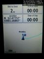
Arrival proof. @52.4776,1.1687
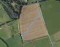
Google Earth Track


Achievements
Sourcerer earned the Midnight Geohash achievement
|

Expeditions and Plans
| 2016-01-11 | ||
|---|---|---|
| Portland, Oregon | Jim | In a residential neighborhood in Hillsboro |
| Norwich, United Kingdom | Sourcerer | A field north of Aslacton, Norfolk, UK. |
Sourcerer's Expedition Links
2016-01-10 52 1 - 2016-01-11 52 1 - 2016-01-13 52 1 - KML file download of Sourcerer's expeditions for use with Google Earth.