Difference between revisions of "2016-01-24 47 -122"
imported>Zebburkeconte (→Expedition) |
imported>FippeBot m (Location) |
||
| (2 intermediate revisions by one other user not shown) | |||
| Line 44: | Line 44: | ||
My dad and I decided to drive up there. We concluded based on the satellite images that it was in the right-turn lane, so we passed through it in the car. Unfortunately it was too close to the intersection to drive through at [[Speed racer achievement|30 mph]]. | My dad and I decided to drive up there. We concluded based on the satellite images that it was in the right-turn lane, so we passed through it in the car. Unfortunately it was too close to the intersection to drive through at [[Speed racer achievement|30 mph]]. | ||
| + | |||
| + | We also watched the end of the AFC Championship not long after hashing. | ||
== Tracklog == | == Tracklog == | ||
| Line 52: | Line 54: | ||
Image:2012-##-## ## ## Alpha.jpg | Witty Comment | Image:2012-##-## ## ## Alpha.jpg | Witty Comment | ||
--> | --> | ||
| + | '''Thomcat''' | ||
| + | |||
<gallery perrow="5"> | <gallery perrow="5"> | ||
| Line 61: | Line 65: | ||
Image:2016-01-24_47_-122_thomcat_1453677153889.jpg|Post hash refreshment [http://www.openstreetmap.org/?lat=47.91070540&lon=-122.22495020&zoom=16&layers=B000FTF @47.9107,-122.2250] | Image:2016-01-24_47_-122_thomcat_1453677153889.jpg|Post hash refreshment [http://www.openstreetmap.org/?lat=47.91070540&lon=-122.22495020&zoom=16&layers=B000FTF @47.9107,-122.2250] | ||
| + | </gallery> | ||
| + | |||
| + | '''zebburkeconte''' | ||
| + | |||
| + | <gallery perrow="5"> | ||
| + | Image:2016-01-24_47_-122_1.jpg|Geohashers | ||
| + | Image:2016-01-24_47_-122_2.jpg|Proof | ||
</gallery> | </gallery> | ||
| Line 70: | Line 81: | ||
[[Category:Expeditions with photos]] | [[Category:Expeditions with photos]] | ||
[[Category:Coordinates reached]] | [[Category:Coordinates reached]] | ||
| + | {{location|US|WA|SN}} | ||
Latest revision as of 06:34, 15 August 2019
| Sun 24 Jan 2016 in Seattle: 47.8970627, -122.2109631 geohashing.info google osm bing/os kml crox |
Location
Near a Texaco station just north of Silver Lake in Everett.
Participants
Plans
Expedition
Thomcat
Got a lot of housework taken care of on Sunday and figured I had time for a geohash. A short drive up the freeway to Everett deposited me just south of Silver Lake, which I circumvented to reach the hashpoint.
When I first opened up the droid, it found the hashpoint on the edge of the road, near the foundation of a light standard and just meters away from a coffee stand. I decorated the side of this with sidewalk chalk and snapped a picture.
Going for the wiki upload, the point was now a meter or so off the curb in the other direction - a relatively busy road. I snapped a selfie and proceeded to upload both.
Following this, I drove a short distance north (but out of visual range, so no pub award here) and had a pint while watching the last 10 suspenseful minutes of the AFC championship game (NFL).
zebburkeconte
My dad and I decided to drive up there. We concluded based on the satellite images that it was in the right-turn lane, so we passed through it in the car. Unfortunately it was too close to the intersection to drive through at 30 mph.
We also watched the end of the AFC Championship not long after hashing.
Tracklog
Photos
Thomcat
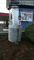
Here @47.8971,-122.2110
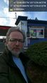
Geohasher @47.8971,-122.2110
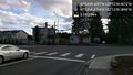
Intersection @47.8971,-122.2109
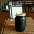
Post hash refreshment @47.9107,-122.2250


zebburkeconte
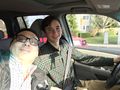
Geohashers
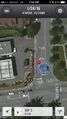
Proof

