Difference between revisions of "2016-02-02 52 1"
From Geohashing
imported>Sourcerer (→Planning) |
imported>FippeBot m (Location) |
||
| (4 intermediate revisions by one other user not shown) | |||
| Line 18: | Line 18: | ||
Wait for Atlantic storm "Henry", the eighth storm in this series, to die down a bit. Then visit the point. | Wait for Atlantic storm "Henry", the eighth storm in this series, to die down a bit. Then visit the point. | ||
| + | |||
| + | Expedition one of two spanning midnight - [[2016-02-02 52 1]] - [[2016-02-03 52 1]] - ETA 23:10. | ||
== Expedition == | == Expedition == | ||
| − | + | The two potential planned parking places were unsuitable. Fortunately there was a better spot at the other end of the field. The walk was slightly longer but easy enough. The field was dry and still had post-harvest wheat stubble. It was a breezy starry night and the temperature was about 4 <sup>o</sup>C. | |
== Photos == | == Photos == | ||
<gallery perrow=4> | <gallery perrow=4> | ||
| + | Image:2016-02-02_52_1_Sourcerer_1454454885459.jpg | Arrival proof. [http://www.openstreetmap.org/?lat=52.88095236&lon=1.32266164&zoom=16&layers=B000FTF @52.8810,1.3227] | ||
| + | Image:2016-02-02_52_1_Sourcerer.jpg | Google Earth Track | ||
</gallery> | </gallery> | ||
| Line 37: | Line 41: | ||
}} | }} | ||
| − | |||
| − | |||
[[Category:Expeditions]] | [[Category:Expeditions]] | ||
[[Category:Expeditions with photos]] | [[Category:Expeditions with photos]] | ||
[[Category:Coordinates reached]] | [[Category:Coordinates reached]] | ||
| − | + | {{location|GB|ENG|NFK}} | |
Latest revision as of 06:37, 15 August 2019
| Tue 2 Feb 2016 in Norwich, UK: 52.8809662, 1.3227008 geohashing.info google osm bing/os kml crox |
Location
A field north of Thorpe Market, Norfolk, UK.
Participants
Plans
Wait for Atlantic storm "Henry", the eighth storm in this series, to die down a bit. Then visit the point.
Expedition one of two spanning midnight - 2016-02-02 52 1 - 2016-02-03 52 1 - ETA 23:10.
Expedition
The two potential planned parking places were unsuitable. Fortunately there was a better spot at the other end of the field. The walk was slightly longer but easy enough. The field was dry and still had post-harvest wheat stubble. It was a breezy starry night and the temperature was about 4 oC.
Photos
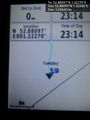
Arrival proof. @52.8810,1.3227
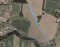
Google Earth Track


Achievements
Expeditions and Plans
| 2016-02-02 | ||
|---|---|---|
| Buffalo, New York | Pedalpusher, Simon the dog, Myka the dog | By Cattaraugus Creek, East of Springville |
| Bonn, Germany | Burgman | A wet meadow north of Seelscheid. |
| Norwich, United Kingdom | Sourcerer | A field north of Thorpe Market, Norfolk, UK. |
Sourcerer's Expedition Links
2016-01-31 52 1 - 2016-02-02 52 1 - 2016-02-03 52 1 - KML file download of Sourcerer's expeditions for use with Google Earth.