Difference between revisions of "2016-04-16 49 8"
From Geohashing
imported>DODO (→Photos) |
imported>DODO (→Achievements) |
||
| Line 56: | Line 56: | ||
{{#vardefine:ribbonwidth|800px}} | {{#vardefine:ribbonwidth|800px}} | ||
<!-- Add any achievement ribbons you earned below, or remove this section --> | <!-- Add any achievement ribbons you earned below, or remove this section --> | ||
| + | {{land geohash | ||
| + | | latitude = 49 | ||
| + | | longitude = 8 | ||
| + | | date = 2016-04-16 | ||
| + | | name = DODO | ||
| + | }} | ||
| − | + | {{Coffin potato | |
| − | + | | latitude = 49 | |
| − | + | | longitude = 8 | |
| + | | date = 2016-04-16 | ||
| + | | deceased = Family Puder (Inge, Anna, Georg and Herrman) | ||
| + | | name = DODO | ||
| + | | image=2016-04-16_49_8-02.jpg | ||
| + | }} | ||
| − | + | {{holy hash | |
| − | + | | latitude = 49 | |
| − | + | | longitude = 8 | |
| − | + | | date = 2016-04-16 | |
| + | | name = DODO | ||
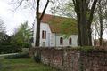
| + | | description = On a graveyard near the church | ||
| + | | image=2016-04-16_49_8-04.jpg | ||
| + | }} | ||
| − | |||
| − | |||
| − | |||
[[Category:Expeditions]] | [[Category:Expeditions]] | ||
| − | |||
[[Category:Expeditions with photos]] | [[Category:Expeditions with photos]] | ||
| − | |||
| − | |||
| − | |||
| − | |||
| − | |||
[[Category:Coordinates reached]] | [[Category:Coordinates reached]] | ||
| − | |||
| − | |||
| − | |||
| − | |||
| − | |||
| − | |||
| − | |||
| − | |||
| − | |||
| − | |||
| − | |||
| − | |||
| − | |||
| − | |||
| − | |||
| − | |||
| − | |||
| − | |||
Revision as of 18:15, 16 April 2016
| Sat 16 Apr 2016 in 49,8: 49.6422736, 8.3089662 geohashing.info google osm bing/os kml crox |
Location
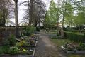
A graveyard in Worms-Leiselheim.
Participants
Plans
I had to drive from Neuwied to Speyer today and a visit of the hash would be only a short detour.
Expedition
Pretty much as planned. Except that the autobahn was blocked between Rheinböllen and Stromberg and I arrived half an hour later than expected.It was just 15 KM detour. Parked 150 m from the hash, walked to the graveyard, took some pictures, witnessed a coffin potato family hash, walked back to the car and drove home. All in all not much more effort than half an hour. Qualifies for a 3.1415928-achievement :-)
Tracklog
500m walk and 15 KM detour by car
Photos
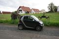
The car brought me 150 m to the hash
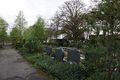
First view to the hash
at the hash
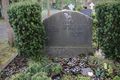
together with whole Puder family
view to the north
and to the south

grin - a stupid one


Achievements
DODO earned the Land geohash achievement
|

DODO certifies that Family Puder (Inge, Anna, Georg and Herrman) earned the Coffin Potato Achievement
by occupying a coffin at the (49, 8) geohash on 2016-04-16.
DODO earned the Holy hash achievement
|