Difference between revisions of "2016-04-18 49 8"
From Geohashing
imported>Q-Owl m (→Photos) |
imported>Q-Owl (→Location) |
||
| Line 7: | Line 7: | ||
== Location == | == Location == | ||
| − | Between [[wikipedia:Gernsheim|Gernsheim]] and Allmendfeld in the upper Rhine valley on a concreted rural road. | + | Between [[wikipedia:Gernsheim|Gernsheim]] and Allmendfeld in the upper Rhine valley; <br>located on a concreted rural road between an asparagus field and a strawberry field. |
| − | |||
== Participants == | == Participants == | ||
Revision as of 19:34, 19 April 2016

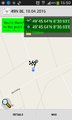
| Mon 18 Apr 2016 in 49,8: 49.7606532, 8.5154285 geohashing.info google osm bing/os kml crox |
Location
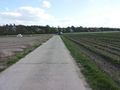
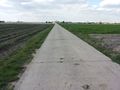
Between Gernsheim and Allmendfeld in the upper Rhine valley;
located on a concreted rural road between an asparagus field and a strawberry field.
Participants
Plan
After work: Drive near the hashpoint between Gernsheim and Allmendfeld, walk to the hp, reach it about 17:00, walk back to the car and drive home.
Expedition
I drove near the hashpoint after work, walked to it, marked it and took a few photos. :-)
The speed racer achievement was not possible, because the road was for residents only.
There was no geocache near the hashpoint. :-(
Photos
Proof
Hashpoint
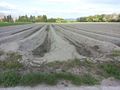
View E (asparagus field)
View S
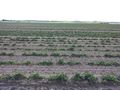
View W (strawberry field)
View N
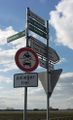
Speed racer not possible - residents only
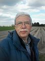
Grin


Achievements / Honorable Mention
Q-Owl & Q-Owla earned the Land geohash achievement
|
Other Geohashing Expeditions and Plans on this Day
Expeditions and Plans
| 2016-04-18 | ||
|---|---|---|
| Mannheim, Germany | Q-Owl | Between Gernsheim and Allmendfeld in the upper Rhine valley; located on a c... |
| Cambridge, United Kingdom | Sourcerer | A meadow divided into allotments near Pott Row, Norfolk, UK. |
| Norwich, United Kingdom | Sourcerer | A footpath point, south of Stalham, Norfolk, UK |