Difference between revisions of "2016-04-18 52 1"
From Geohashing
imported>Sourcerer m (→Planning) |
imported>FippeBot m (Location) |
||
| (3 intermediate revisions by one other user not shown) | |||
| Line 21: | Line 21: | ||
== Expedition == | == Expedition == | ||
| + | A slightly muddy walk led to the hashpoint which was on the path as expected. This was lucky because the fences and drainage ditches would have prevented deviation off the path. | ||
| + | My arrival time was 21:41. Not 23:41 as claimed by my GPSr which seemed to be on Moscow time for some reason. | ||
== Photos == | == Photos == | ||
<gallery perrow="5"> | <gallery perrow="5"> | ||
| + | Image:2016-04-18_52_1_Sourcerer_1461012085295.jpg | Arrived. [http://www.openstreetmap.org/?lat=52.76064456&lon=1.51542664&zoom=16&layers=B000FTF @52.7606,1.5154] | ||
| + | Image:2016-04-18_52_1_Sourcerer.jpg | Google Earth Track | ||
</gallery> | </gallery> | ||
| Line 34: | Line 38: | ||
| prev = 2016-04-17 52 1 | | prev = 2016-04-17 52 1 | ||
| curr = 2016-04-18 52 1 | | curr = 2016-04-18 52 1 | ||
| − | | next = 2016-04- | + | | next = 2016-04-18 52 0 |
| date = 2016-04-18 | | date = 2016-04-18 | ||
}} | }} | ||
| − | |||
| − | |||
[[Category:Expeditions]] | [[Category:Expeditions]] | ||
[[Category:Expeditions with photos]] | [[Category:Expeditions with photos]] | ||
[[Category:Coordinates reached]] | [[Category:Coordinates reached]] | ||
| − | + | {{location|GB|ENG|NFK}} | |
Latest revision as of 00:16, 16 August 2019
| Mon 18 Apr 2016 in Norwich, UK: 52.7606532, 1.5154285 geohashing.info google osm bing/os kml crox |
Location
A footpath point, south of Stalham, Norfolk, UK
Participants
Plans
One of three spanning midnight - 2016-04-18 52 1 - 2016-04-18 52 0 - 2016-04-19 52 0 - ETA 21:35.
Expedition
A slightly muddy walk led to the hashpoint which was on the path as expected. This was lucky because the fences and drainage ditches would have prevented deviation off the path.
My arrival time was 21:41. Not 23:41 as claimed by my GPSr which seemed to be on Moscow time for some reason.
Photos
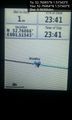
Arrived. @52.7606,1.5154
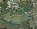
Google Earth Track


Achievements
Expeditions and Plans
| 2016-04-18 | ||
|---|---|---|
| Mannheim, Germany | Q-Owl | Between Gernsheim and Allmendfeld in the upper Rhine valley; located on a c... |
| Cambridge, United Kingdom | Sourcerer | A meadow divided into allotments near Pott Row, Norfolk, UK. |
| Norwich, United Kingdom | Sourcerer | A footpath point, south of Stalham, Norfolk, UK |
Sourcerer's Expedition Links
2016-04-17 52 1 - 2016-04-18 52 1 - 2016-04-18 52 0 - KML file download of Sourcerer's expeditions for use with Google Earth.