Difference between revisions of "2016-04-22 49 8"
imported>Q-Owl m (→Location) |
imported>FippeBot m (Location) |
||
| (6 intermediate revisions by one other user not shown) | |||
| Line 1: | Line 1: | ||
| − | [[Image:2016-04-22 49 8 | + | [[Image:2016-04-22 49 8 hp.jpg|thumb|left|Q-Owl on the Hashpoint]] |
{{meetup graticule | {{meetup graticule | ||
| lat=49 | | lat=49 | ||
| Line 12: | Line 12: | ||
*[[User:Q-Owl|Q-Owl]] | *[[User:Q-Owl|Q-Owl]] | ||
| + | *[[User:Q-Owla|Q-Owla]] | ||
== Plan == | == Plan == | ||
| − | Quick idea after work: Drive near the hashpoint | + | Quick idea after work: Drive near the hashpoint, walk to the hp, reach it about 16:00, find some geocaches, walk back to the car and drive home. |
| − | |||
== Expedition == | == Expedition == | ||
| − | + | We drove to the ferry at Gernsheim ([http://opencaching.de/OC11EA8 my cache OC11EA8]), enterd it by car and payed only 1.30 € for Q-Owla's one way ticket. For the car and driver we have a ten-ride ferry ticket there. | |
| − | |||
| − | |||
| − | The | + | The hashpoint was in a vinyard near Undenheim and easy to reach and find. We took a few photos and after this we went to the geocaches around the hashpoint. Two of them had a distance of only 250 m (GC2REYM east and GC1YBJN south) and in direct sight. |
| − | + | On the way back we found more geocaches and later we used the ferry at Nierstein (4.80 €). | |
| Line 34: | Line 32: | ||
<gallery perrow="5" > | <gallery perrow="5" > | ||
| − | Image:2016-04-22 | + | Image:Screenshot 2016-04-22-16-52-56.png | Proof |
| − | Image:2016-04-22 49 8 hp.jpg | Hashpoint | + | Image:2016-04-22 49 8 hp.jpg | Q-Owl standing on the Hashpoint |
| − | Image:2016-04-22 49 8 | + | Image:2016-04-22 49 8 hpa.jpg | Q-Owla next to the Hashpoint, looking East; |
| − | Image:2016-04-22 49 8 s.jpg | | + | Image:2016-04-22 49 8 s.jpg | Looking South |
| − | Image:2016-04-22 49 8 w.jpg | | + | Image:2016-04-22 49 8 w.jpg | Looking West |
| − | Image:2016-04-22 49 8 n.jpg | | + | Image:2016-04-22 49 8 n.jpg | Looking North |
</gallery> | </gallery> | ||
<!-- | <!-- | ||
| Line 59: | Line 57: | ||
| name = Q-Owl & Q-Owla | | name = Q-Owl & Q-Owla | ||
}} | }} | ||
| + | {{gratuitous ribbon | ||
| + | | color = green | ||
| + | | icon = Ferry-pic44x44.jpg | ||
| + | | latitude = 49 | ||
| + | | longitude = 8 | ||
| + | | date = 2016-04-22 | ||
| + | | achievement = Ferry Achievement | ||
| + | | description = using two ferries on the way to the hash and back | ||
| + | | name = Q-Owl & Q-Owla | ||
| + | }} | ||
| + | {{Admit One geohash | ||
| + | | latitude = 49 | ||
| + | | longitude = 8 | ||
| + | | date = 2016-04-22 | ||
| + | | name = Q-Owl & Q-Owla | ||
| + | | price = 1.30 € + 4.80 € | ||
| + | | venue = Rhine ferries at Gernsheim and Nierstein | ||
| + | }} | ||
| + | {{Public transport geohash | ||
| + | | latitude = 49 | ||
| + | | longitude = 8 | ||
| + | | date = 2016-04-22 | ||
| + | | name = Q-Owl & Q-Owla | ||
| + | }} | ||
<!-- | <!-- | ||
Have I really been the only one? | Have I really been the only one? | ||
| Line 67: | Line 89: | ||
| name = [[User:Q-Owl|Q-Owl]] | | name = [[User:Q-Owl|Q-Owl]] | ||
}} --> | }} --> | ||
| − | |||
| − | |||
| − | |||
== Other Geohashing Expeditions and Plans on this Day == | == Other Geohashing Expeditions and Plans on this Day == | ||
| Line 93: | Line 112: | ||
[[Category: Meetup on 2016-04-22]] | [[Category: Meetup on 2016-04-22]] | ||
[[Category: Meetup in 49 8]] | [[Category: Meetup in 49 8]] | ||
| + | {{location|DE|RP|MZ}} | ||
Latest revision as of 00:17, 16 August 2019

| Fri 22 Apr 2016 in 49,8: 49.8286635, 8.2571726 geohashing.info google osm bing/os kml crox |
Location
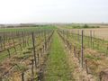
Near Undenheim in the upper Rhine valley; located in a vinyard.
Participants
Plan
Quick idea after work: Drive near the hashpoint, walk to the hp, reach it about 16:00, find some geocaches, walk back to the car and drive home.
Expedition
We drove to the ferry at Gernsheim (my cache OC11EA8), enterd it by car and payed only 1.30 € for Q-Owla's one way ticket. For the car and driver we have a ten-ride ferry ticket there.
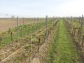
The hashpoint was in a vinyard near Undenheim and easy to reach and find. We took a few photos and after this we went to the geocaches around the hashpoint. Two of them had a distance of only 250 m (GC2REYM east and GC1YBJN south) and in direct sight.
On the way back we found more geocaches and later we used the ferry at Nierstein (4.80 €).
Photos
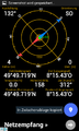
Proof
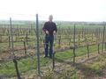
Q-Owl standing on the Hashpoint
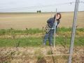
Q-Owla next to the Hashpoint, looking East;
Looking South
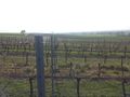
Looking West
Looking North


Achievements / Honorable Mention
Q-Owl & Q-Owla earned the Land geohash achievement
|
Q-Owl & Q-Owla earned the Ferry Achievement
|

Q-Owl & Q-Owla earned the Public transport geohash achievement
|
Other Geohashing Expeditions and Plans on this Day
Expeditions and Plans
| 2016-04-22 | ||
|---|---|---|
| Washington (West), District of Columbia | McKay | Difficult Run Stream Valley Trail Park |
| Buffalo, New York | Pedalpusher | In a field off Rt 20 in Darien, NY |
| Szombathely, Hungary | B2c, Crankl, OtherJack | Sidewalk in the outer part of Wiener Neustadt, Austria |
| Stuttgart, Germany | Drei aus Korb | Fellbach Schmiden near Stuttgart, Germany |
| Mannheim, Germany | Q-Owl, Q-Owla | Near Undenheim in the upper Rhine valley; located in a vinyard. |
| Norwich, United Kingdom | Sourcerer | A field perimeter close to a public footpath between Erpingham and Ingworth... |