Difference between revisions of "2016-04-22 52 1"
imported>Sourcerer m ([live picture] Early. [http://www.openstreetmap.org/?lat=52.82868683&lon=1.25719428&zoom=16&layers=B000FTF @52.8287,1.2572]) |
m (linkfix) |
||
| (10 intermediate revisions by 2 users not shown) | |||
| Line 1: | Line 1: | ||
| − | + | {{meetup graticule | |
| − | |||
| − | |||
| − | |||
| − | |||
| − | |||
| − | |||
| − | |||
| − | |||
| − | |||
| − | {{meetup graticule | ||
| lat=52 | | lat=52 | ||
| lon=1 | | lon=1 | ||
| date=2016-04-22 | | date=2016-04-22 | ||
| + | | graticule_name=Norwich, UK | ||
| + | | graticule_link=Norwich, United Kingdom | ||
}} | }} | ||
| − | |||
| − | |||
__NOTOC__ | __NOTOC__ | ||
| + | == Location == | ||
| − | + | A field perimeter close to a public footpath between Erpingham and Ingworth, Norfolk, UK. | |
| − | |||
== Participants == | == Participants == | ||
| − | + | ||
| − | + | *[[User:Sourcerer|Sourcerer]] | |
== Plans == | == Plans == | ||
| − | + | ||
| + | Two of two spanning midnight - [[2016-04-21 52 1]] - [[2016-04-22 52 1]] - ETA 00:00. | ||
== Expedition == | == Expedition == | ||
| − | |||
| − | + | There was dry parking at the start of the pubic footpath. The hashpoint lay between two crops. I walked about 4 minutes beyond the hashpoint to kill a bit of time before midnight. | |
| − | |||
== Photos == | == Photos == | ||
| − | + | ||
| − | |||
| − | |||
<gallery perrow="5"> | <gallery perrow="5"> | ||
| − | |||
Image:2016-04-22_52_1_Sourcerer_1461278904304.jpg | Early. [http://www.openstreetmap.org/?lat=52.82868683&lon=1.25719428&zoom=16&layers=B000FTF @52.8287,1.2572] | Image:2016-04-22_52_1_Sourcerer_1461278904304.jpg | Early. [http://www.openstreetmap.org/?lat=52.82868683&lon=1.25719428&zoom=16&layers=B000FTF @52.8287,1.2572] | ||
| + | Image:2016-04-22_52_1_Sourcerer_1461279600902.jpg | Yea. Midnight. [http://www.openstreetmap.org/?lat=52.82864392&lon=1.25711381&zoom=16&layers=B000FTF @52.8286,1.2571] | ||
| + | Image:2016-04-22 52 1 Sourcerer.jpg | Google Earth Track | ||
</gallery> | </gallery> | ||
== Achievements == | == Achievements == | ||
{{#vardefine:ribbonwidth|800px}} | {{#vardefine:ribbonwidth|800px}} | ||
| − | |||
| − | + | {{Midnight geohash | |
| − | + | | latitude = 52 | |
| − | + | | longitude = 1 | |
| + | | date = 2016-04-22 | ||
| + | | name = Sourcerer | ||
| + | }} | ||
| − | + | On this day, Sourcerer had stood in more fields than any other geohasher. [[Most active Geohashers]] agrees but has counted three more expeditions than I have so the exact "award day" is uncertain by a couple of expeditions either way. | |
| − | |||
| − | [[ | ||
| − | |||
| − | + | [[File:2016-04-22 52 1 Sourcerer Trophy.jpg]] | |
| + | |||
| + | {{Sourcerer_links | ||
| + | | prev = 2016-04-21 52 1 | ||
| + | | curr = 2016-04-22 52 1 | ||
| + | | next = 2016-04-23 52 1 | ||
| + | | date = 2016-04-22 | ||
| + | }} | ||
| − | |||
[[Category:Expeditions]] | [[Category:Expeditions]] | ||
| − | |||
[[Category:Expeditions with photos]] | [[Category:Expeditions with photos]] | ||
| − | |||
| − | |||
| − | |||
| − | |||
| − | |||
[[Category:Coordinates reached]] | [[Category:Coordinates reached]] | ||
| − | + | {{location|GB|ENG|NFK}} | |
| − | |||
| − | |||
| − | |||
| − | |||
| − | |||
| − | |||
| − | |||
| − | |||
| − | |||
| − | |||
| − | |||
| − | |||
| − | |||
| − | |||
| − | |||
| − | |||
| − | |||
Latest revision as of 21:15, 19 February 2023
| Fri 22 Apr 2016 in Norwich, UK: 52.8286635, 1.2571726 geohashing.info google osm bing/os kml crox |
Location
A field perimeter close to a public footpath between Erpingham and Ingworth, Norfolk, UK.
Participants
Plans
Two of two spanning midnight - 2016-04-21 52 1 - 2016-04-22 52 1 - ETA 00:00.
Expedition
There was dry parking at the start of the pubic footpath. The hashpoint lay between two crops. I walked about 4 minutes beyond the hashpoint to kill a bit of time before midnight.
Photos
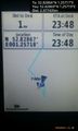
Early. @52.8287,1.2572
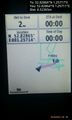
Yea. Midnight. @52.8286,1.2571
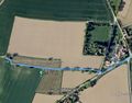
Google Earth Track


Achievements
Sourcerer earned the Midnight Geohash achievement
|
On this day, Sourcerer had stood in more fields than any other geohasher. Most active Geohashers agrees but has counted three more expeditions than I have so the exact "award day" is uncertain by a couple of expeditions either way.

Expeditions and Plans
| 2016-04-22 | ||
|---|---|---|
| Washington (West), District of Columbia | McKay | Difficult Run Stream Valley Trail Park |
| Buffalo, New York | Pedalpusher | In a field off Rt 20 in Darien, NY |
| Szombathely, Hungary | B2c, Crankl, OtherJack | Sidewalk in the outer part of Wiener Neustadt, Austria |
| Stuttgart, Germany | Drei aus Korb | Fellbach Schmiden near Stuttgart, Germany |
| Mannheim, Germany | Q-Owl, Q-Owla | Near Undenheim in the upper Rhine valley; located in a vinyard. |
| Norwich, United Kingdom | Sourcerer | A field perimeter close to a public footpath between Erpingham and Ingworth... |
Sourcerer's Expedition Links
2016-04-21 52 1 - 2016-04-22 52 1 - 2016-04-23 52 1 - KML file download of Sourcerer's expeditions for use with Google Earth.