Difference between revisions of "2016-06-14 52 1"
imported>Sourcerer m ([live picture] Arrived [http://www.openstreetmap.org/?lat=52.20367370&lon=1.48464630&zoom=16&layers=B000FTF @52.2037,1.4846]) |
imported>Sourcerer m (→New expedition) |
||
| Line 1: | Line 1: | ||
| − | + | {{meetup graticule | |
| − | |||
| − | |||
| − | |||
| − | |||
| − | |||
| − | |||
| − | |||
| − | |||
| − | |||
| − | {{meetup graticule | ||
| lat=52 | | lat=52 | ||
| lon=1 | | lon=1 | ||
| date=2016-06-14 | | date=2016-06-14 | ||
| + | | graticule_name=Norwich, UK | ||
| + | | graticule_link=Norwich, United Kingdom | ||
}} | }} | ||
| − | |||
| − | |||
__NOTOC__ | __NOTOC__ | ||
| + | == Location == | ||
| − | + | A rapeseed field south of Sternfield, Suffolk, UK. | |
| − | |||
== Participants == | == Participants == | ||
| − | + | ||
| − | + | [[User:Sourcerer|Sourcerer]] | |
== Plans == | == Plans == | ||
| − | + | ||
| + | Two of two spanning midnight - [[2016-06-13 52 1]] - [[2016-06-14 52 1]] - ETA 00:00. | ||
== Expedition == | == Expedition == | ||
| − | |||
| − | + | The first two approaches led to tall wet rapeseed plants. Walking via the road, it was possible to get closer. A bushwhack through thorns and nettles led back into the field. 25 metres later, there was the hashpoint. The rapeseed has not grown so well this year. It flowered too early due to an unusually warm winter and the plants are smaller than usual. Full size plants can't easily be penetrated. Progress was very wet though. It was still raining. | |
| − | |||
== Photos == | == Photos == | ||
| − | |||
| − | |||
| − | |||
| − | |||
| + | <gallery perrow="3"> | ||
Image:2016-06-14_52_1_Sourcerer_1465859292050.jpg | Arrived [http://www.openstreetmap.org/?lat=52.20367370&lon=1.48464630&zoom=16&layers=B000FTF @52.2037,1.4846] | Image:2016-06-14_52_1_Sourcerer_1465859292050.jpg | Arrived [http://www.openstreetmap.org/?lat=52.20367370&lon=1.48464630&zoom=16&layers=B000FTF @52.2037,1.4846] | ||
| + | Image:2016-06-14_52_1_Sourcerer.jpg | Google Earth Track | ||
</gallery> | </gallery> | ||
== Achievements == | == Achievements == | ||
{{#vardefine:ribbonwidth|800px}} | {{#vardefine:ribbonwidth|800px}} | ||
| − | |||
| − | + | {{Midnight geohash | |
| − | + | | latitude = 52 | |
| − | + | | longitude = 1 | |
| + | | date = 2016-06-14 | ||
| + | | name = Sourcerer | ||
| + | }} | ||
| − | + | {{Sourcerer_links | |
| − | + | | prev = 2016-06-13 52 1 | |
| − | + | | curr = 2016-06-14 52 1 | |
| − | + | | next = 2016-06-15 52 1 | |
| − | + | | date = 2016-06-14 | |
| − | -- | + | }} |
| − | |||
| − | |||
| − | |||
[[Category:Expeditions]] | [[Category:Expeditions]] | ||
| − | |||
[[Category:Expeditions with photos]] | [[Category:Expeditions with photos]] | ||
| − | |||
| − | |||
| − | |||
| − | |||
| − | |||
[[Category:Coordinates reached]] | [[Category:Coordinates reached]] | ||
| − | |||
| − | |||
| − | |||
| − | |||
| − | |||
| − | |||
| − | |||
| − | |||
| − | |||
| − | |||
| − | |||
| − | |||
| − | |||
| − | |||
| − | |||
| − | |||
| − | |||
| − | |||
Revision as of 00:18, 14 June 2016
| Tue 14 Jun 2016 in Norwich, UK: 52.1965109, 1.4991206 geohashing.info google osm bing/os kml crox |
Location
A rapeseed field south of Sternfield, Suffolk, UK.
Participants
Plans
Two of two spanning midnight - 2016-06-13 52 1 - 2016-06-14 52 1 - ETA 00:00.
Expedition
The first two approaches led to tall wet rapeseed plants. Walking via the road, it was possible to get closer. A bushwhack through thorns and nettles led back into the field. 25 metres later, there was the hashpoint. The rapeseed has not grown so well this year. It flowered too early due to an unusually warm winter and the plants are smaller than usual. Full size plants can't easily be penetrated. Progress was very wet though. It was still raining.
Photos
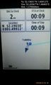
Arrived @52.2037,1.4846
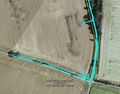
Google Earth Track


Achievements
Sourcerer earned the Midnight Geohash achievement
|
Expeditions and Plans
| 2016-06-14 | ||
|---|---|---|
| Preston, Idaho | Bravissimo594, Boppy5 | In an agricultural field close to a road west of Soda Springs. |
| Norwich, United Kingdom | Sourcerer | A rapeseed field south of Sternfield, Suffolk, UK. |
Sourcerer's Expedition Links
2016-06-13 52 1 - 2016-06-14 52 1 - 2016-06-15 52 1 - KML file download of Sourcerer's expeditions for use with Google Earth.