Difference between revisions of "2016-06-16 49 8"
From Geohashing
imported>Q-Owl (Created page with "thumb|left|The Hashpoint {{meetup graticule | lat=49 | lon=8 | date=2016-06-16 }}__NOTOC__ == Location == At the Rhine River near wikipedi...") |
imported>Q-Owl (→Achievements / Honorable Mention) |
||
| Line 59: | Line 59: | ||
| name = Q-Owl | | name = Q-Owl | ||
}} | }} | ||
| + | {{Geotrash | ||
| + | | latitude = 49 | ||
| + | | longitude = 8 | ||
| + | | date = 2016-06-16 | ||
| + | | name = Q-Owl | ||
| + | | image = image name (optional) | ||
| + | }} | ||
<!-- | <!-- | ||
Have I really been the only one? | Have I really been the only one? | ||
| Line 67: | Line 74: | ||
| name = [[User:Q-Owl|Q-Owl]] | | name = [[User:Q-Owl|Q-Owl]] | ||
}} --> | }} --> | ||
| − | |||
| − | |||
== Other Geohashing Expeditions and Plans on this Day == | == Other Geohashing Expeditions and Plans on this Day == | ||
Revision as of 15:30, 16 June 2016

| Thu 16 Jun 2016 in 49,8: 49.7242667, 8.4445866 geohashing.info google osm bing/os kml crox |
Location
At the Rhine River near Groß-Rohrheim
Participants
Plan
Drive near the hashpoint, reach it, walk back to the car, find a few geocaches and drive home.
But after may days of rain the River may have flooded the meadows next to it, where the hashpoint lies.
Expedition
Success! :-)
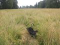
Photos
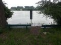
Rhine River - filled to the rim
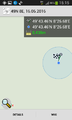
Proof
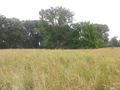
Looking East
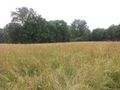
Looking South
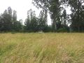
Looking West
Looking North


Achievements / Honorable Mention
Q-Owl earned the Land geohash achievement
|
Q-Owl earned the GeoTrash Geohash Achievement
|
Other Geohashing Expeditions and Plans on this Day
Expeditions and Plans
| 2016-06-16 | ||
|---|---|---|
| West Yellowstone, Montana | Bravissimo594, Boppy5, Mickey | The point appears to be in an agricultural field, northwest of Henrys Lake,... |
| Mannheim, Germany | Q-Owl | At the Rhine River near Groß-Rohrheim |
| Norwich, United Kingdom | Sourcerer | A field between Hoveton and Cangate, Norfolk, UK. There is a public footpat... |