Difference between revisions of "2016-06-16 49 8"
From Geohashing
imported>Q-Owl m (→Expedition) |
imported>Q-Owl |
||
| Line 1: | Line 1: | ||
| − | [[Image:2016-06-16 49 8 | + | [[Image:2016-06-16 49 8 c.jpg|thumb|left|Rhine River - filled]] |
{{meetup graticule | {{meetup graticule | ||
| lat=49 | | lat=49 | ||
| Line 20: | Line 20: | ||
But after may days of rain the River may have flooded the meadows next to it, where the hashpoint lies. So it might be impossible to reach this point without a boat or fishing wader (Wathose). | But after may days of rain the River may have flooded the meadows next to it, where the hashpoint lies. So it might be impossible to reach this point without a boat or fishing wader (Wathose). | ||
| + | |||
== Expedition == | == Expedition == | ||
| Line 38: | Line 39: | ||
Image:2016-06-16 49 8 w.jpg | Looking West | Image:2016-06-16 49 8 w.jpg | Looking West | ||
Image:2016-06-16 49 8 n.jpg | Looking North | Image:2016-06-16 49 8 n.jpg | Looking North | ||
| + | Image:2016-06-16 49 8 g.jpg | Grin with umbrella | ||
| + | Image:2016-06-16 49 8 gb.jpg | Good bye | ||
</gallery> | </gallery> | ||
<!-- | <!-- | ||
| Line 45: | Line 48: | ||
http://wiki.xkcd.com/geohashing/User:Q-Owl#HowTo_in_this_Wiki | http://wiki.xkcd.com/geohashing/User:Q-Owl#HowTo_in_this_Wiki | ||
--> | --> | ||
| + | |||
== Achievements / Honorable Mention == | == Achievements / Honorable Mention == | ||
| Line 70: | Line 74: | ||
| name = [[User:Q-Owl|Q-Owl]] | | name = [[User:Q-Owl|Q-Owl]] | ||
}} --> | }} --> | ||
| + | |||
== Other Geohashing Expeditions and Plans on this Day == | == Other Geohashing Expeditions and Plans on this Day == | ||
Revision as of 16:25, 16 June 2016

| Thu 16 Jun 2016 in 49,8: 49.7242667, 8.4445866 geohashing.info google osm bing/os kml crox |
Location
At the Rhine River near Groß-Rohrheim
Participants
Plan
Drive near the hashpoint, reach it, walk back to the car, find a few geocaches and drive home.
But after may days of rain the River may have flooded the meadows next to it, where the hashpoint lies. So it might be impossible to reach this point without a boat or fishing wader (Wathose).
Expedition
Success! :-)
At the hashpoint I took a few photos and walked back to the car, where I had a nice talk with a man from Groß-Rohrheim.
But I could not solve the riddle of GC31WGW "Gefällt mir" on my Galaxy S2 and so I drove home without finding a geocache. - At home I found the solution.
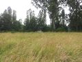
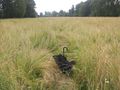
Photos
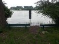
Rhine River - filled to the rim
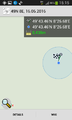
Proof
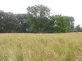
Looking East
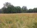
Looking South
Looking West
Looking North
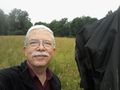
Grin with umbrella
Good bye


Achievements / Honorable Mention
Q-Owl earned the Land geohash achievement
|
Q-Owl earned the GeoTrash Geohash Achievement
|
Other Geohashing Expeditions and Plans on this Day
Expeditions and Plans
| 2016-06-16 | ||
|---|---|---|
| West Yellowstone, Montana | Bravissimo594, Boppy5, Mickey | The point appears to be in an agricultural field, northwest of Henrys Lake,... |
| Mannheim, Germany | Q-Owl | At the Rhine River near Groß-Rohrheim |
| Norwich, United Kingdom | Sourcerer | A field between Hoveton and Cangate, Norfolk, UK. There is a public footpat... |