Difference between revisions of "2016-06-16 52 1"
imported>Sourcerer m (→New expedition) |
imported>FippeBot m (Location) |
||
| (3 intermediate revisions by one other user not shown) | |||
| Line 21: | Line 21: | ||
== Expedition == | == Expedition == | ||
| − | My [[2016-06-15_52_1#Expedition|pigeon failure]] continued. Going clockwise, image below, there was an inviting path that did not lead to the hashpoint. A confusing sign said the path ended in 150 metres. The signpost arrows had been broken off so there was no clue what the sign actually meant. Any interpretation was permissible. | + | My [[2016-06-15_52_1#Expedition|pigeon failure]] continued. Going clockwise, image below, there was an inviting path that did not lead to the hashpoint. A confusing sign said the path ended in 150 metres. The signpost arrows had been broken off so there was no clue what the sign actually meant. Any interpretation was permissible. About 90 metres from the hashpoint, after some blundering around in a woodland glade with a moonlit pool (nice) this route was aborted. |
| − | After a backtrack to the car, approach two, anticlockwise, led straight back to the woodland glade and the original path. Drat. The first backtrack was not necessary. Another backtrack led to the entrance to the correct field. There was a perimeter path in a deep groove made by the plough. On one side there was a flowery border. On the other was a tall crop of barley. All the vegetation was saturated from earlier thunderstorms. My soaking before midnight was topped up but this vegetation was | + | After a backtrack to the car, approach two, anticlockwise, led straight back to the woodland glade and the original path. Drat. The first backtrack was not necessary. Another backtrack led to the entrance to the correct field. There was a perimeter path in a deep groove made by the plough. On one side there was a flowery border. On the other was a tall crop of barley. All the vegetation was saturated from earlier thunderstorms. My soaking before midnight was topped up but this vegetation was taller. 20 metres from the hashpoint, an orthogonal tractor track led to the destination. I arrived an hour and a half late. |
| − | On the drive home, low level fog was forming. This hid the road surface but not the hedgerow borders. Unexpectedly a fog pool turned out to be a surprisingly deep water pool. With a huge wave and spray the car tripped out of cruise control, put its transmission into neutral and coasted to a halt in the middle of the flood. Oh crap, I've killed my car! But no. The engine was still running. Once I'd worked out that I had to put the car back into "drive", it was possible to emerge dripping from the flood with no harm done. Well done | + | On the drive home, low level fog was forming. This hid the road surface but not the hedgerow borders. Unexpectedly a fog pool turned out to be a surprisingly deep water pool. With a huge wave and spray the car tripped out of cruise control, put its transmission into neutral and coasted to a halt in the middle of the flood. Oh crap, I've killed my car! But no. The engine was still running. Once I'd worked out that I had to put the car back into "drive", it was possible to emerge, dripping, from the flood with no harm done. Well done Škoda for water proofing and putting the air intakes outside the spray and wave zone. |
| − | Back home at 02:30 feeling tired, muddy | + | Back home at 02:30 feeling tired, muddy clingy wet garments had to be peeled off and various residues showered off. Expedition report writing was deferred to the next day. |
== Photos == | == Photos == | ||
| − | <gallery perrow="3"> | + | <gallery caption="Photo Gallery" widths="200px" heights="200px" perrow="3"> |
Image:2016-06-16 52 1 Sourcerer Proof.jpg | Proof | Image:2016-06-16 52 1 Sourcerer Proof.jpg | Proof | ||
Image:2016-06-16 52 1 Sourcerer.jpg | Google Earth Track | Image:2016-06-16 52 1 Sourcerer.jpg | Google Earth Track | ||
| Line 49: | Line 49: | ||
| prev = 2016-06-15 52 1 | | prev = 2016-06-15 52 1 | ||
| curr = 2016-06-16 52 1 | | curr = 2016-06-16 52 1 | ||
| − | | next = 2016-06- | + | | next = 2016-06-19 52 1 |
| date = 2016-06-16 | | date = 2016-06-16 | ||
}} | }} | ||
| Line 56: | Line 56: | ||
[[Category:Expeditions with photos]] | [[Category:Expeditions with photos]] | ||
[[Category:Coordinates reached]] | [[Category:Coordinates reached]] | ||
| + | {{location|GB|ENG|NFK}} | ||
Latest revision as of 00:47, 16 August 2019
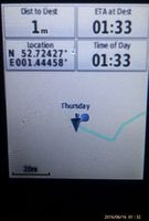
| Thu 16 Jun 2016 in Norwich, UK: 52.7242667, 1.4445866 geohashing.info google osm bing/os kml crox |
Location
A field between Hoveton and Cangate, Norfolk, UK. There is a public footpath quite close.
Participants
Plans
Two of two spanning midnight - 2016-06-15 52 1 - 2016-06-16 52 1 - ETA 00:00.
Expedition
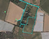
My pigeon failure continued. Going clockwise, image below, there was an inviting path that did not lead to the hashpoint. A confusing sign said the path ended in 150 metres. The signpost arrows had been broken off so there was no clue what the sign actually meant. Any interpretation was permissible. About 90 metres from the hashpoint, after some blundering around in a woodland glade with a moonlit pool (nice) this route was aborted.
After a backtrack to the car, approach two, anticlockwise, led straight back to the woodland glade and the original path. Drat. The first backtrack was not necessary. Another backtrack led to the entrance to the correct field. There was a perimeter path in a deep groove made by the plough. On one side there was a flowery border. On the other was a tall crop of barley. All the vegetation was saturated from earlier thunderstorms. My soaking before midnight was topped up but this vegetation was taller. 20 metres from the hashpoint, an orthogonal tractor track led to the destination. I arrived an hour and a half late.
On the drive home, low level fog was forming. This hid the road surface but not the hedgerow borders. Unexpectedly a fog pool turned out to be a surprisingly deep water pool. With a huge wave and spray the car tripped out of cruise control, put its transmission into neutral and coasted to a halt in the middle of the flood. Oh crap, I've killed my car! But no. The engine was still running. Once I'd worked out that I had to put the car back into "drive", it was possible to emerge, dripping, from the flood with no harm done. Well done Škoda for water proofing and putting the air intakes outside the spray and wave zone.
Back home at 02:30 feeling tired, muddy clingy wet garments had to be peeled off and various residues showered off. Expedition report writing was deferred to the next day.
Photos
- Photo Gallery
Proof
Google Earth Track


Achievements
Sourcerer earned the Midnight Geohash achievement
|
Expeditions and Plans
| 2016-06-16 | ||
|---|---|---|
| West Yellowstone, Montana | Bravissimo594, Boppy5, Mickey | The point appears to be in an agricultural field, northwest of Henrys Lake,... |
| Mannheim, Germany | Q-Owl | At the Rhine River near Groß-Rohrheim |
| Norwich, United Kingdom | Sourcerer | A field between Hoveton and Cangate, Norfolk, UK. There is a public footpat... |
Sourcerer's Expedition Links
2016-06-15 52 1 - 2016-06-16 52 1 - 2016-06-19 52 1 - KML file download of Sourcerer's expeditions for use with Google Earth.