Difference between revisions of "2016-06-24 52 1"
From Geohashing
imported>Sourcerer m ([live picture] Arrived. [http://www.openstreetmap.org/?lat=52.21058786&lon=1.36357069&zoom=16&layers=B000FTF @52.2106,1.3636]) |
imported>Sourcerer m (→Achievements) |
||
| Line 39: | Line 39: | ||
}} | }} | ||
| − | |||
| − | |||
[[Category:Expeditions]] | [[Category:Expeditions]] | ||
[[Category:Expeditions with photos]] | [[Category:Expeditions with photos]] | ||
[[Category:Coordinates reached]] | [[Category:Coordinates reached]] | ||
| − | |||
Revision as of 23:22, 23 June 2016
| Fri 24 Jun 2016 in Norwich, UK: 52.2105911, 1.3635387 geohashing.info google osm bing/os kml crox |
Location
260 metres from 2015-06-11 52 1 in a field south east of Framlingham, Suffolk, UK.
Participants
Plans
Two of two spanning midnight - 2016-06-23 52 1 - 2016-06-24 52 1 - ETA 00:00.
Expedition
Photos
- Photo Gallery
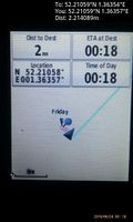
Arrived. @52.2106,1.3636

Achievements
Expeditions and Plans
| 2016-06-24 | ||
|---|---|---|
| Mannheim, Germany | DODO | On a bicycle lane in Germersheim |
| Norwich, United Kingdom | Sourcerer | 260 metres from 2015-06-11 52 1 in a field south east of Framlingham, Suffolk, UK. |
Sourcerer's Expedition Links
2016-06-23 52 1 - 2016-06-24 52 1 - 2016-06-25 52 1 - KML file download of Sourcerer's expeditions for use with Google Earth.