Difference between revisions of "2016-07-31 52 1"
From Geohashing
imported>Sourcerer m ([live picture] Arrived. [http://www.openstreetmap.org/?lat=52.35049188&lon=1.44165516&zoom=16&layers=B000FTF @52.3505,1.4417]) |
imported>Sourcerer m (→New expedition) |
||
| Line 17: | Line 17: | ||
== Plans == | == Plans == | ||
| − | + | Go at dusk. | |
== Expedition == | == Expedition == | ||
| + | This was close to home and easy. A public footpath led into a wheat field. The verge was wide enough to park safely. At the end of the first field, tractor tracks led west. There was a kink in the field followed by an easy hedgerow squeeze. Now, in small sugar beet plants, it was a few paces to the hashpoint. The return route used slightly more convenient tractor tracks. | ||
== Photos == | == Photos == | ||
<gallery caption="Photo Gallery" widths="200px" heights="200px" perrow="3"> | <gallery caption="Photo Gallery" widths="200px" heights="200px" perrow="3"> | ||
| − | |||
Image:2016-07-31_52_1_Sourcerer_1469998361235.jpg | Arrived. [http://www.openstreetmap.org/?lat=52.35049188&lon=1.44165516&zoom=16&layers=B000FTF @52.3505,1.4417] | Image:2016-07-31_52_1_Sourcerer_1469998361235.jpg | Arrived. [http://www.openstreetmap.org/?lat=52.35049188&lon=1.44165516&zoom=16&layers=B000FTF @52.3505,1.4417] | ||
| + | Image:2016-07-31_52_1_Sourcerer.jpg | Google Earth Track | ||
</gallery> | </gallery> | ||
| Line 38: | Line 39: | ||
}} | }} | ||
| − | |||
| − | |||
[[Category:Expeditions]] | [[Category:Expeditions]] | ||
[[Category:Expeditions with photos]] | [[Category:Expeditions with photos]] | ||
[[Category:Coordinates reached]] | [[Category:Coordinates reached]] | ||
| − | |||
Revision as of 21:51, 31 July 2016
| Sun 31 Jul 2016 in Norwich, UK: 52.3504780, 1.4416551 geohashing.info google osm bing/os kml crox |
Location
A field between Linstead Parva and Chediston Green, Suffolk, UK.
Participants
Plans
Go at dusk.
Expedition
This was close to home and easy. A public footpath led into a wheat field. The verge was wide enough to park safely. At the end of the first field, tractor tracks led west. There was a kink in the field followed by an easy hedgerow squeeze. Now, in small sugar beet plants, it was a few paces to the hashpoint. The return route used slightly more convenient tractor tracks.
Photos
- Photo Gallery
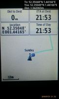
Arrived. @52.3505,1.4417
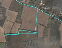
Google Earth Track


Achievements
Expeditions and Plans
| 2016-07-31 | ||
|---|---|---|
| Kassel, Germany | GeorgDerReisende | The hash lay on a field at the western end of Vellmar. |
| Norwich, United Kingdom | Sourcerer | A field between Linstead Parva and Chediston Green, Suffolk, UK. |
Sourcerer's Expedition Links
2016-07-29 52 1 - 2016-07-31 52 1 - 2016-08-02 52 1 - KML file download of Sourcerer's expeditions for use with Google Earth.