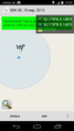
2016-09-15 52 5
| Thu 15 Sep 2016 in 52,5: 52.1778541, 5.1880936 geohashing.info google osm bing/os kml crox |
Location
Just off the road in Hollandse Rading
Participants
Plans
Bike there and walk up
Expedition
Nice and sunny day, promising to be hot again as we currently have a heatwave going on. So would http://xkcd.com/1732/ it be true then?
Missed a few turns on my way there, wanting to cycle through the meadows of the Hollandse Waterlinie, the defence system that was in effect in the 16th through 19th centuries. By flooding the low lands (polders) in which numerous brooks ran, any army would be slowed down because of the inability to orient and the many trenches hidden underneath the water surface. Restored windmills, protestant churches on the horizon, and small flocks of cattle grazing green meadows indicated that it for sure was the Netherlands I was biking through.
Yet large areas are turned "back into nature"
Tracklog
Photos
underneath the tree
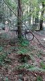
view from hash to bike
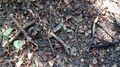
twigs mark the spot


Achievements
JwB earned the Bicycle geohash achievement
|