Difference between revisions of "2016-12-27 51 -0"
From Geohashing
imported>Sourcerer m (→New expedition) |
imported>FippeBot m (Location) |
||
| (4 intermediate revisions by one other user not shown) | |||
| Line 4: | Line 4: | ||
| date=2016-12-27 | | date=2016-12-27 | ||
| graticule_name=London west, UK | | graticule_name=London west, UK | ||
| − | | graticule_link=London | + | | graticule_link=London West, United Kingdom |
}} | }} | ||
__NOTOC__ | __NOTOC__ | ||
== Location == | == Location == | ||
| − | A residential street close to the M40 west of High Wycombe, Buckinghamshire, UK. | + | A residential street in Chinnor close to the M40 west of High Wycombe, Buckinghamshire, UK. |
== Participants == | == Participants == | ||
| Line 37: | Line 37: | ||
{{Sourcerer_links | {{Sourcerer_links | ||
| prev = 2016-12-21 52 1 | | prev = 2016-12-21 52 1 | ||
| − | | curr = 2016-12-27 | + | | curr = 2016-12-27 51 -0 |
| − | | next = 2016-12- | + | | next = 2016-12-31 52 0 |
| date = 2016-12-27 | | date = 2016-12-27 | ||
}} | }} | ||
| Line 45: | Line 45: | ||
[[Category:Expeditions with photos]] | [[Category:Expeditions with photos]] | ||
[[Category:Coordinates reached]] | [[Category:Coordinates reached]] | ||
| + | {{location|GB|ENG|OXF}} | ||
Latest revision as of 01:54, 16 August 2019
| Tue 27 Dec 2016 in London west, UK: 51.6971973, -0.9121946 geohashing.info google osm bing/os kml crox |
Location
A residential street in Chinnor close to the M40 west of High Wycombe, Buckinghamshire, UK.
Participants
Plans
Go on the way home from two Christmas parties, via yet another celebratory lunch. Fatness!
Expedition
Divert 5 miles north of the M40. Fail to stand on the zero point. I'd parked right on it.
Photos
- Photo Gallery
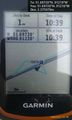
Arrived. @51.6972,-.9122
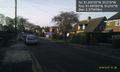
Looking west. @51.6972,-.9122
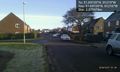
Looking east. @51.6972,-.9122


Achievements
Expeditions and Plans
| 2016-12-27 | ||
|---|---|---|
| London West, United Kingdom | Sourcerer | A residential street in Chinnor close to the M40 west of High Wycombe, Buck... |
Sourcerer's Expedition Links
2016-12-21 52 1 - 2016-12-27 51 -0 - 2016-12-31 52 0 - KML file download of Sourcerer's expeditions for use with Google Earth.