Difference between revisions of "2017-01-05 49 8"
imported>DODO (Created page with "{{subst:Expedition |lat = 49 |lon = 8 |date = 2017-01-05 }}") |
m (Location correction) |
||
| (4 intermediate revisions by 2 users not shown) | |||
| Line 19: | Line 19: | ||
== Location == | == Location == | ||
| − | + | 80 meters in a field between Wallstadt, Ilvesheim and Ladenburg. | |
== Participants == | == Participants == | ||
<!-- who attended: If you link to your wiki user name in this section, your expedition will be picked up by the various statistics generated for geohashing. You may use three tildes ~ as a shortcut to automatically insert the user signature of the account you are editing with. | <!-- who attended: If you link to your wiki user name in this section, your expedition will be picked up by the various statistics generated for geohashing. You may use three tildes ~ as a shortcut to automatically insert the user signature of the account you are editing with. | ||
--> | --> | ||
| − | + | [[User:DODO|DODO]] | |
== Plans == | == Plans == | ||
<!-- what were the original plans --> | <!-- what were the original plans --> | ||
| + | Go there by bull in the morning and gaining a birthday achievement. | ||
== Expedition == | == Expedition == | ||
<!-- how it all turned out. your narrative goes here. --> | <!-- how it all turned out. your narrative goes here. --> | ||
| + | I took a day of today because of my 50th birthday. My family wants to come at 1 pm, so I had to go early, but I still had to do some cleaning before I could leave. The lady had to work, so I came out of bed early and had some time. That's why I decided to take the bull and use a train to come back home. It was cold and the road was very slippery in some parts so I couldn't ride as fast as I wanted, but after 75 minutes I reached the hashfield. It was freshly ploughed and frozen. So it was very uneven and hard to walk but at least it wasn't muddy. I took the usual pictures and hurried on to Mannheim Main station, where I took a train to Speyer 20 minutes later. | ||
| + | |||
| + | I even reached a tron achievement. I didn't cross the rail tracks, I took - I usually never do that - the wrong side to cross the bridge in Speyer so I hadn't to cross my own track there, although the track shows something different, I didn't randomly walk around in the Mannheim main station, nor in Ludwigshafen Main station (I lost bps-reception there and the track is really obscure there, but I promise I just sat in the train. | ||
| + | |||
| + | I'm pretty sure that it was far below 0°C but I have no proof of that. | ||
== Tracklog == | == Tracklog == | ||
<!-- if your GPS device keeps a log, you may post a link here --> | <!-- if your GPS device keeps a log, you may post a link here --> | ||
| + | [https://www.komoot.de/tour/13884978 44 KM by bull and 21 by train] | ||
== Photos == | == Photos == | ||
| Line 38: | Line 45: | ||
Image:2012-##-## ## ## Alpha.jpg | Witty Comment | Image:2012-##-## ## ## Alpha.jpg | Witty Comment | ||
--> | --> | ||
| − | <gallery perrow=" | + | |
| + | <gallery perrow="6"> | ||
| + | Image:2017-01-05_49_8-6.png|proof | ||
| + | Image:2017-01-05_49_8-1.jpg|view to the east | ||
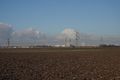
| + | Image:2017-01-05_49_8-2.jpg|the south (and the bull) | ||
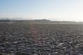
| + | Image:2017-01-05_49_8-5.jpg|northwest | ||
| + | Image:2017-01-05_49_8-3.jpg|the hasher | ||
| + | Image:2017-01-05_49_8-4.jpg|another view to the bull. Snowy and slippery road | ||
</gallery> | </gallery> | ||
== Achievements == | == Achievements == | ||
{{#vardefine:ribbonwidth|800px}} | {{#vardefine:ribbonwidth|800px}} | ||
| − | + | {{land geohash | |
| + | | latitude = 49 | ||
| + | | longitude = 8 | ||
| + | | date = 2017-01-05 | ||
| + | | name = DODO | ||
| + | }} | ||
| − | + | {{Template:Tron | |
| − | + | | latitude = 49 | |
| − | + | | longitude = 8 | |
| + | | date = 2017-01-05 | ||
| + | | name = DODO | ||
| + | | possessive = his | ||
| + | | tracklog = https://www.komoot.de/tour/13884978 | ||
| + | }} | ||
| − | + | {{Birthday geohash | |
| + | | latitude = 49 | ||
| + | | longitude = 8 | ||
| + | | date = 2017-01-05 | ||
| + | | pronoun = his | ||
| + | | name = DODO | ||
| + | | number = 50 | ||
| + | }} | ||
| − | + | [[Category:Expeditions]] | |
| − | |||
| − | [[Category: | ||
| − | |||
| − | |||
| − | |||
| − | |||
| − | |||
| − | |||
| − | |||
| − | |||
| − | |||
| − | |||
| − | |||
| − | |||
[[Category:Coordinates reached]] | [[Category:Coordinates reached]] | ||
| − | + | {{location|DE|BW|HD}} | |
| − | |||
| − | |||
| − | |||
| − | |||
| − | |||
| − | |||
| − | |||
| − | |||
| − | |||
| − | |||
| − | |||
| − | |||
| − | |||
| − | |||
| − | |||
| − | |||
| − | |||
Latest revision as of 20:35, 16 May 2020
| Thu 5 Jan 2017 in 49,8: 49.4931695, 8.5743895 geohashing.info google osm bing/os kml crox |
Location
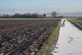
80 meters in a field between Wallstadt, Ilvesheim and Ladenburg.
Participants
Plans
Go there by bull in the morning and gaining a birthday achievement.
Expedition
I took a day of today because of my 50th birthday. My family wants to come at 1 pm, so I had to go early, but I still had to do some cleaning before I could leave. The lady had to work, so I came out of bed early and had some time. That's why I decided to take the bull and use a train to come back home. It was cold and the road was very slippery in some parts so I couldn't ride as fast as I wanted, but after 75 minutes I reached the hashfield. It was freshly ploughed and frozen. So it was very uneven and hard to walk but at least it wasn't muddy. I took the usual pictures and hurried on to Mannheim Main station, where I took a train to Speyer 20 minutes later.
I even reached a tron achievement. I didn't cross the rail tracks, I took - I usually never do that - the wrong side to cross the bridge in Speyer so I hadn't to cross my own track there, although the track shows something different, I didn't randomly walk around in the Mannheim main station, nor in Ludwigshafen Main station (I lost bps-reception there and the track is really obscure there, but I promise I just sat in the train.
I'm pretty sure that it was far below 0°C but I have no proof of that.
Tracklog
Photos
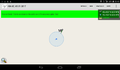
proof
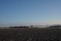
view to the east
the south (and the bull)
northwest

the hasher
another view to the bull. Snowy and slippery road


Achievements
DODO earned the Land geohash achievement
|
DODO earned the Tron achievement
|
DODO earned the Birthday Geohash Achievement
|