Difference between revisions of "2017-01-08 43 -79"
From Geohashing
m (More specific location) |
m (existing file, removing non-existing file) |
||
| Line 1: | Line 1: | ||
| − | + | {{meetup graticule | |
| map=<map lat="43" lon="-79" date="2017-01-08" /> | | map=<map lat="43" lon="-79" date="2017-01-08" /> | ||
| lat=43 | | lat=43 | ||
| Line 35: | Line 35: | ||
<gallery perrow="5"> | <gallery perrow="5"> | ||
| − | Image:viewnorth | + | Image:viewnorth.jpg | The view north from the hashpoint. |
| − | |||
</gallery> | </gallery> | ||
Latest revision as of 18:46, 15 September 2020
| Sun 8 Jan 2017 in Toronto: 43.1744002, -79.8444916 geohashing.info google osm bing/os kml crox |
Graticule
Location
South of Hamilton near a factory for a bakery.
Participants
Expedition
I was on my way back to college and was driving by, thought I would stop to grab a geohash somewhere.
This one was only a fifteen-minute drive off my route. I drove to the parking lot of the bakery, which got me within 100 meters of the hashpoint. I then jumped over a frozen brook and walked a little bit to the hashpoint, which was right at a fence at the boundary of the factory. Pretty cold, but still a good hashpoint.
It was great to be here!
Photos
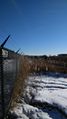
The view north from the hashpoint.

Achievements
- Land Geohash