Difference between revisions of "2017-01-22 31 -97"
imported>Thunk |
imported>FippeBot m (Location) |
||
| (3 intermediate revisions by one other user not shown) | |||
| Line 19: | Line 19: | ||
== Location == | == Location == | ||
| − | Right lane of eastbound US-190 near Harker Heights, Bell County, Texas, US. | + | Right lane of eastbound US-190 (now I-14) near Harker Heights, Bell County, Texas, US. |
== Participants == | == Participants == | ||
| Line 44: | Line 44: | ||
--> | --> | ||
<gallery perrow="5"> | <gallery perrow="5"> | ||
| + | Image:2017-01-22-hashpoint1.jpg | Before driving through the hashpoint... | ||
| + | Image:2017-01-22-hashpoint2.jpg | ...and after | ||
| + | Image:Screenshot_2017-01-22.png | Tried to catch the position, but it didn't show up. Too fast! | ||
</gallery> | </gallery> | ||
| Line 49: | Line 52: | ||
{{#vardefine:ribbonwidth|800px}} | {{#vardefine:ribbonwidth|800px}} | ||
<!-- Add any achievement ribbons you earned below, or remove this section --> | <!-- Add any achievement ribbons you earned below, or remove this section --> | ||
| + | {{Speed racer | latitude = 31 | longitude = -97 | date = 2017-01-22 | name = thunk | speed = 76 mph }} | ||
| + | {{Tron | ||
| + | | latitude = 31 | ||
| + | | longitude = -97 | ||
| + | | date = 2017-01-22 | ||
| + | | name = thunk | ||
| + | | tracklog = https://drive.google.com/open?id=1IMHlVvrWg-0KzrLNEf6eBbfn45E&usp=sharing} | ||
| + | | possessive = their | ||
| + | }} | ||
| + | {{drag-along | ||
| + | | latitude = 31 | ||
| + | | longitude = -97 | ||
| + | | date = 2017-01-22 | ||
| + | | partner = their dad | ||
| + | | name = thunk | ||
| + | }} | ||
| + | {{gratuitous ribbon | ||
| + | | color = gray | ||
| + | | icon = Speedracer.png | ||
| + | | latitude = 31 | ||
| + | | longitude = -97 | ||
| + | | date = 2017-01-22 | ||
| + | | achievement = Hashcab achievement | ||
| + | | description = picking up and dropping off a bystander on the way to the | ||
| + | | name = [[User:Thunk|thunk]] | ||
| + | }} | ||
<!-- =============== USEFUL CATEGORIES FOLLOW ================ | <!-- =============== USEFUL CATEGORIES FOLLOW ================ | ||
Delete the next line ONLY if you have chosen the appropriate categories below. If you are unsure, don't worry. People will read your report and help you with the classification. --> | Delete the next line ONLY if you have chosen the appropriate categories below. If you are unsure, don't worry. People will read your report and help you with the classification. --> | ||
| − | |||
| − | + | [[Category:Expeditions]] | |
| − | + | [[Category:Expeditions with photos]] | |
| − | |||
| − | |||
| − | |||
| − | |||
| − | |||
| − | |||
| − | |||
| − | |||
| − | |||
| − | |||
| − | |||
| − | |||
| − | |||
| − | |||
[[Category:Coordinates reached]] | [[Category:Coordinates reached]] | ||
| − | + | {{location|US|TX|BL}} | |
| − | |||
| − | |||
| − | |||
| − | |||
| − | |||
| − | |||
| − | |||
| − | |||
| − | |||
| − | |||
| − | |||
| − | |||
| − | |||
| − | |||
| − | |||
| − | |||
| − | |||
Latest revision as of 02:19, 7 August 2019
| Sun 22 Jan 2017 in 31,-97: 31.0832887, -97.6347389 geohashing.info google osm bing/os kml crox |
Location
Right lane of eastbound US-190 (now I-14) near Harker Heights, Bell County, Texas, US.
Participants
Plans
The plan was to drive there and back. Also get Tron. Simple. ?
Expedition
Surprise breakfast happened, then I left with my dragalong driving the vehicle. However, an additional complication ensued as we had a third person who needed to be dropped off at their house. Since they lived in a cul-de-sac, this would ordinarily have precluded the Tron achievement. No matter; it turns out you can ensure horizontal separation by holding your GPS device out of the car window.
Anyway, the dropoff occurred, and it was off to the hashpoint. Since my family ordinarily sees little point in hashing, upon arrival in Killeen we decided to examine whether the city had an interesting downtown. The answer was in the negative.
Then, it was off to US-190; eight km west of the hashpoint, we got on the freeway, and accelerated to the speed limit at the point, 75 mph (which was slightly higher than the speed limit there, but well below the speed of overtaking traffic.) A truck in front worried us, but it was easy to temporarily slow down and accelerate so that the speed could be maintained through the point itself.
We finally missed the turn home, and using the frontage roads was out of the question as it would entail path-crossing. No matter; local roads 10 km to the east allowed a crossing of the Leon River. Afterwards, arriving back at our starting point (4 hours later) was easy.
Tracklog
Photos
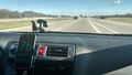
Before driving through the hashpoint...
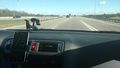
...and after
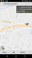
Tried to catch the position, but it didn't show up. Too fast!


Achievements

thunk earned the Tron achievement
|
thunk earned the Drag-along achievement
|
thunk earned the Hashcab achievement
|