Difference between revisions of "2017-03-15 48 -123"
imported>Wijnland (create expedition) |
m (More specific location) |
||
| (2 intermediate revisions by 2 users not shown) | |||
| Line 1: | Line 1: | ||
<!-- If you did not specify these parameters in the template, please substitute appropriate values for IMAGE, LAT, LON, and DATE (YYYY-MM-DD format) | <!-- If you did not specify these parameters in the template, please substitute appropriate values for IMAGE, LAT, LON, and DATE (YYYY-MM-DD format) | ||
| − | |||
| − | |||
Remove this section if you don't want an image at the top (left) of your report. You should remove the "Image:" or "File:" | Remove this section if you don't want an image at the top (left) of your report. You should remove the "Image:" or "File:" | ||
| Line 17: | Line 15: | ||
<!-- edit as necessary --> | <!-- edit as necessary --> | ||
__NOTOC__ | __NOTOC__ | ||
| + | [[Image:Wijnland_20170315_2572.jpg|640px]] | ||
== Location == | == Location == | ||
<!-- where you've surveyed the hash to be --> | <!-- where you've surveyed the hash to be --> | ||
| + | In front of Esquimalt Harbour, between Fishgard lighthouse and Brothers Islands. | ||
== Participants == | == Participants == | ||
| − | + | * [[User:Wijnland|Wijnland]] ([[User talk:Wijnland|talk]]) | |
| − | + | ||
| + | == Expedition == | ||
| + | I had been lazy and did not keep track of hashes for a while, but a friend asked me about geohashing for some university course (yes, it will likely be included in some GIS classes at UBC) So I checked to find this great waterhash really close to home. I already had my canoe on me from a little paddle in the morning so decided it needed to be done. I was unable to find any drag alongs so went by myself. I launched at the little beach at the end of Foster St. in Esquimalt around 17.00 and canoed out. I reached the hash at 17.30 continued to fisgard lighthouse for some pictures and was back at my car around 18.30. There was some light rain, and very light winds. A perfectly nice paddel in the evening. | ||
| − | + | there was much widlife to see: Harbour seals, river otter, bald eagle, bunch of gulls, common mergansers, great blue heron, canada goose, other duck like things. fun was had. | |
| − | |||
| − | |||
| − | |||
| − | |||
| − | |||
== Photos == | == Photos == | ||
| − | + | ||
| − | |||
| − | |||
<gallery perrow="5"> | <gallery perrow="5"> | ||
| + | Image:Wijnland_20170315_2555.jpg | Coordinates Reached | ||
| + | Image:Wijnland_20170315_7.jpg | ~330deg panorama | ||
| + | Image:Wijnland_20170315_2579.jpg | At the nearby Fisgard Lighthouse | ||
| + | Image:Wijnland_20170315_2586.jpg | The lighthouse is old and special | ||
</gallery> | </gallery> | ||
== Achievements == | == Achievements == | ||
{{#vardefine:ribbonwidth|800px}} | {{#vardefine:ribbonwidth|800px}} | ||
| + | {{water geohash | ||
| + | | latitude = 48 | ||
| + | | longitude = -123 | ||
| + | | date = 2017-03-15 | ||
| + | | name = [[User:Wijnland|Wijnland]] | ||
| + | | image = Wijnland_20170315_2572.jpg | ||
| + | | vehicle = Alucida (canoe) | ||
| + | }} | ||
<!-- Add any achievement ribbons you earned below, or remove this section --> | <!-- Add any achievement ribbons you earned below, or remove this section --> | ||
| − | <!-- =============== USEFUL CATEGORIES FOLLOW ================ | + | <!-- =============== USEFUL CATEGORIES FOLLOW ================--> |
| − | |||
| − | |||
| − | |||
| − | |||
| − | |||
| − | |||
| − | |||
| − | |||
| − | |||
| − | |||
| − | |||
| − | |||
[[Category:Expeditions]] | [[Category:Expeditions]] | ||
| − | |||
[[Category:Expeditions with photos]] | [[Category:Expeditions with photos]] | ||
| − | |||
| − | |||
| − | |||
| − | |||
| − | |||
[[Category:Coordinates reached]] | [[Category:Coordinates reached]] | ||
| − | + | {{location|CA|BC|CP}} | |
| − | |||
| − | |||
| − | |||
| − | |||
| − | |||
| − | |||
| − | |||
| − | |||
| − | |||
| − | |||
| − | |||
| − | |||
| − | |||
| − | |||
| − | |||
| − | |||
| − | |||
Latest revision as of 00:12, 10 August 2020
| Wed 15 Mar 2017 in 48,-123: 48.4217432, -123.4441185 geohashing.info google osm bing/os kml crox |

Location
In front of Esquimalt Harbour, between Fishgard lighthouse and Brothers Islands.
Participants
Expedition
I had been lazy and did not keep track of hashes for a while, but a friend asked me about geohashing for some university course (yes, it will likely be included in some GIS classes at UBC) So I checked to find this great waterhash really close to home. I already had my canoe on me from a little paddle in the morning so decided it needed to be done. I was unable to find any drag alongs so went by myself. I launched at the little beach at the end of Foster St. in Esquimalt around 17.00 and canoed out. I reached the hash at 17.30 continued to fisgard lighthouse for some pictures and was back at my car around 18.30. There was some light rain, and very light winds. A perfectly nice paddel in the evening.
there was much widlife to see: Harbour seals, river otter, bald eagle, bunch of gulls, common mergansers, great blue heron, canada goose, other duck like things. fun was had.
Photos
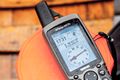
Coordinates Reached

~330deg panorama
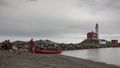
At the nearby Fisgard Lighthouse
The lighthouse is old and special


Achievements
Wijnland earned the Water geohash achievement
|