Difference between revisions of "2017-04-08 52 1"
imported>Sourcerer m ([live picture] View. [http://www.openstreetmap.org/?lat=52.32641101&lon=1.34066463&zoom=16&layers=B000FTF @52.3264,1.3407]) |
imported>Sourcerer m (→New expedition) |
||
| Line 1: | Line 1: | ||
| − | + | {{meetup graticule | |
| − | |||
| − | |||
| − | |||
| − | |||
| − | |||
| − | |||
| − | |||
| − | |||
| − | |||
| − | {{meetup graticule | ||
| lat=52 | | lat=52 | ||
| lon=1 | | lon=1 | ||
| date=2017-04-08 | | date=2017-04-08 | ||
| + | | graticule_name=Norwich, UK | ||
| + | | graticule_link=Norwich, United Kingdom | ||
}} | }} | ||
| − | |||
| − | |||
__NOTOC__ | __NOTOC__ | ||
| + | == Location == | ||
| − | + | A field west of Chippenhall and Swan Greens, Suffolk, UK. | |
| − | |||
== Participants == | == Participants == | ||
| − | + | ||
| − | + | [[User:Sourcerer|Sourcerer]] | |
== Plans == | == Plans == | ||
| − | + | ||
| + | Went on a whim to take advantage of more nice spring weather. | ||
== Expedition == | == Expedition == | ||
| − | |||
| − | + | The public footpath was not properly signposted so I made a best effort attempt and followed the wrong field perimeter. Near the hashpoint, I failed to locate the correct path but my wanderings took me to the zero point. Most convenient. Sometimes I lead walks for the Suffolk Ramblers' group, so I have a genuine reason for wanting to locate the correct path. Farmers could avoid significant crop damage by maintaining the finger posts that mark the correct path. | |
| − | |||
| − | + | In the image bewlow, the red tracks are designated rights of way. I doubt if my eTrex Vista has the capacity to store all these trails so I lacked the exaxt information needed on the expedition. | |
| − | |||
| − | |||
| − | |||
| − | |||
| + | == Photos == | ||
| + | <gallery caption="Gallery" widths="200px" heights="200px" perrow="3"> | ||
Image:2017-04-08_52_1_Sourcerer_1491649794006.jpg | Arrived. [http://www.openstreetmap.org/?lat=52.32641637&lon=1.34066999&zoom=16&layers=B000FTF @52.3264,1.3407] | Image:2017-04-08_52_1_Sourcerer_1491649794006.jpg | Arrived. [http://www.openstreetmap.org/?lat=52.32641637&lon=1.34066999&zoom=16&layers=B000FTF @52.3264,1.3407] | ||
| − | |||
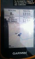
Image:2017-04-08_52_1_Sourcerer_1491649814631.jpg | View. [http://www.openstreetmap.org/?lat=52.32641101&lon=1.34066463&zoom=16&layers=B000FTF @52.3264,1.3407] | Image:2017-04-08_52_1_Sourcerer_1491649814631.jpg | View. [http://www.openstreetmap.org/?lat=52.32641101&lon=1.34066463&zoom=16&layers=B000FTF @52.3264,1.3407] | ||
| + | Image:2017-04-08_52_1_Sourcerer.jpg | Google Earth Track | ||
</gallery> | </gallery> | ||
== Achievements == | == Achievements == | ||
{{#vardefine:ribbonwidth|800px}} | {{#vardefine:ribbonwidth|800px}} | ||
| − | |||
| − | + | {{Sourcerer_links | |
| − | + | | prev = 2017-04-03 52 1 | |
| − | + | | curr = 2017-04-08 52 1 | |
| + | | next = 2017-04-10 52 1 | ||
| + | | date = 2017-04-08 | ||
| + | }} | ||
| − | |||
| − | |||
| − | |||
| − | |||
| − | |||
| − | |||
| − | |||
| − | |||
| − | |||
| − | |||
[[Category:Expeditions]] | [[Category:Expeditions]] | ||
| − | |||
[[Category:Expeditions with photos]] | [[Category:Expeditions with photos]] | ||
| − | |||
| − | |||
| − | |||
| − | |||
| − | |||
[[Category:Coordinates reached]] | [[Category:Coordinates reached]] | ||
| − | |||
| − | |||
| − | |||
| − | |||
| − | |||
| − | |||
| − | |||
| − | |||
| − | |||
| − | |||
| − | |||
| − | |||
| − | |||
| − | |||
| − | |||
| − | |||
| − | |||
| − | |||
Revision as of 12:13, 8 April 2017
| Sat 8 Apr 2017 in Norwich, UK: 52.3263985, 1.3406244 geohashing.info google osm bing/os kml crox |
Location
A field west of Chippenhall and Swan Greens, Suffolk, UK.
Participants
Plans
Went on a whim to take advantage of more nice spring weather.
Expedition
The public footpath was not properly signposted so I made a best effort attempt and followed the wrong field perimeter. Near the hashpoint, I failed to locate the correct path but my wanderings took me to the zero point. Most convenient. Sometimes I lead walks for the Suffolk Ramblers' group, so I have a genuine reason for wanting to locate the correct path. Farmers could avoid significant crop damage by maintaining the finger posts that mark the correct path.
In the image bewlow, the red tracks are designated rights of way. I doubt if my eTrex Vista has the capacity to store all these trails so I lacked the exaxt information needed on the expedition.
Photos
- Gallery
Arrived. @52.3264,1.3407
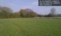
View. @52.3264,1.3407
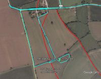
Google Earth Track


Achievements
Expeditions and Plans
| 2017-04-08 | ||
|---|---|---|
| Roswell, Georgia | NWoodruff | Up on a hill under some high tension power lines in Ball Ground. |
| Mannheim, Germany | DODO | A meadow near Hanhofen |
| Kassel, Germany | GeorgDerReisende | The hash lay in the Habichtswald near the Kleiner Auskopf. |
| Norwich, United Kingdom | Sourcerer | A field west of Chippenhall and Swan Greens, Suffolk, UK. |
Sourcerer's Expedition Links
2017-04-03 52 1 - 2017-04-08 52 1 - 2017-04-10 52 1 - KML file download of Sourcerer's expeditions for use with Google Earth.