Difference between revisions of "2017-04-10 52 1"
imported>Sourcerer m (→New expedition) |
imported>FippeBot m (Location) |
||
| (4 intermediate revisions by 2 users not shown) | |||
| Line 13: | Line 13: | ||
== Participants == | == Participants == | ||
| − | [[User:Sourcerer|Sourcerer]] | + | * [[User:ChromeCrusaders|ChromeCrusaders]] and independently ... |
| + | * [[User:Sourcerer|Sourcerer]] | ||
== Plans == | == Plans == | ||
| − | Go in the evening after the traffic dies down a bit. | + | Un-planned - [[User:ChromeCrusaders|ChromeCrusaders]] |
| + | |||
| + | Go in the evening after the traffic dies down a bit. - [[User:Sourcerer|Sourcerer]] | ||
== Expedition == | == Expedition == | ||
| + | |||
| + | === [[User:ChromeCrusaders|ChromeCrusaders]] === | ||
| + | |||
| + | * Did it. | ||
| + | - I thought I would be able to get the point by road, parking on the curb but wasn't quite close enough so I parked at a near by pub and walked. | ||
| + | |||
| + | -- [[User:ChromeCrusaders|ChromeCrusaders]] ([[User talk:ChromeCrusaders|talk]]) [http://www.openstreetmap.org/?lat=52.57759830&lon=1.33954670&zoom=16&layers=B000FTF @52.5776,1.3395] 19:08, 10 April 2017 (GMT+01:00) | ||
| + | |||
| + | === [[User:Sourcerer|Sourcerer]] === | ||
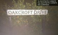
After a short tresspass into a front drive, it turned out that the hashpoint was on the public side of the hedge. Uploading the evidence photos was routine but I got some odd looks as I was facing the hedge and leaning in to get my distance down to about a metre. I was not taking a pee! Honest! | After a short tresspass into a front drive, it turned out that the hashpoint was on the public side of the hedge. Uploading the evidence photos was routine but I got some odd looks as I was facing the hedge and leaning in to get my distance down to about a metre. I was not taking a pee! Honest! | ||
| Line 28: | Line 40: | ||
Image:2017-04-10_52_1_Sourcerer_1491854944921.jpg | Location [http://www.openstreetmap.org/?lat=52.57761598&lon=1.33958101&zoom=16&layers=B000FTF @52.5776,1.3396] | Image:2017-04-10_52_1_Sourcerer_1491854944921.jpg | Location [http://www.openstreetmap.org/?lat=52.57761598&lon=1.33958101&zoom=16&layers=B000FTF @52.5776,1.3396] | ||
Image:2017-04-10_52_1_Sourcerer.jpg | Google Earth Track | Image:2017-04-10_52_1_Sourcerer.jpg | Google Earth Track | ||
| + | Image:2017-04-10 52 1-2-.jpg | CC Picture | ||
| + | Image:Screenshot_2016-04-02-16-49-34-1-.png | CC Proof | ||
</gallery> | </gallery> | ||
| Line 36: | Line 50: | ||
| prev = 2017-04-08 52 1 | | prev = 2017-04-08 52 1 | ||
| curr = 2017-04-10 52 1 | | curr = 2017-04-10 52 1 | ||
| − | | next = 2017-04- | + | | next = 2017-04-21 52 1 |
| date = 2017-04-10 | | date = 2017-04-10 | ||
}} | }} | ||
| Line 43: | Line 57: | ||
[[Category:Expeditions with photos]] | [[Category:Expeditions with photos]] | ||
[[Category:Coordinates reached]] | [[Category:Coordinates reached]] | ||
| + | {{location|GB|ENG|NFK}} | ||
Latest revision as of 02:23, 16 August 2019
| Mon 10 Apr 2017 in Norwich, UK: 52.5776200, 1.3396337 geohashing.info google osm bing/os kml crox |
Location
The pavement and cycle track north of Poringland, Norfolk, UK.
Participants
- ChromeCrusaders and independently ...
- Sourcerer
Plans
Un-planned - ChromeCrusaders
Go in the evening after the traffic dies down a bit. - Sourcerer
Expedition
ChromeCrusaders
- Did it.
- I thought I would be able to get the point by road, parking on the curb but wasn't quite close enough so I parked at a near by pub and walked.
-- ChromeCrusaders (talk) @52.5776,1.3395 19:08, 10 April 2017 (GMT+01:00)
Sourcerer
After a short tresspass into a front drive, it turned out that the hashpoint was on the public side of the hedge. Uploading the evidence photos was routine but I got some odd looks as I was facing the hedge and leaning in to get my distance down to about a metre. I was not taking a pee! Honest!
Photos
- Gallery
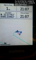
Arrived. @52.5776,1.3396
Location @52.5776,1.3396
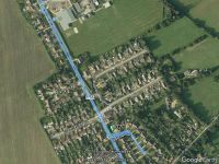
Google Earth Track
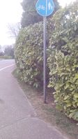
CC Picture
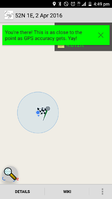
CC Proof


Achievements
Expeditions and Plans
| 2017-04-10 | ||
|---|---|---|
| Norwich, United Kingdom | ChromeCrusaders, Sourcerer, independently ... | The pavement and cycle track north of Poringland, Norfolk, UK. |
Sourcerer's Expedition Links
2017-04-08 52 1 - 2017-04-10 52 1 - 2017-04-21 52 1 - KML file download of Sourcerer's expeditions for use with Google Earth.