Difference between revisions of "2017-04-13 48 11"
imported>Solli |
m (Location correction) |
||
| (4 intermediate revisions by 2 users not shown) | |||
| Line 17: | Line 17: | ||
== Expedition == | == Expedition == | ||
| − | + | Since the hashpoint was not far from my office I decided to go there after work. Getting there took a while due to heavy traffic on Holy Thursday afternoon. I parked the car a few hundred metres away and went to the field. As it turned out it was a freshly planted potatoe field. I walked along the nearby river, but for the last ~20m I had to get into the field. I paid attention to only step between the rows of potatoes, so I didn't damage anything. The expedition was quite uneventful, but the nearby stream is quite nice. Anyway, it was my first expedition in the Ingolstadt area. | |
| − | |||
| − | |||
| − | |||
== Photos == | == Photos == | ||
| − | |||
| − | |||
| − | |||
<gallery perrow="5"> | <gallery perrow="5"> | ||
| + | Image:2017-04-13 48 11 Solli 01.jpg | View from the hashpoint | ||
| + | Image:2017-04-13 48 11 Solli 02.png | Proof | ||
| + | Image:2017-04-13 48 11 Solli 03.jpg | The hashfield | ||
| + | Image:2017-04-13 48 11 Solli 04.jpg | Nearby stream | ||
</gallery> | </gallery> | ||
== Achievements == | == Achievements == | ||
{{#vardefine:ribbonwidth|800px}} | {{#vardefine:ribbonwidth|800px}} | ||
| − | + | {{land geohash | |
| − | + | | latitude = 48 | |
| − | + | | longitude = 11 | |
| − | + | | date = 2017-04-13 | |
| − | + | | name = Solli | |
| − | + | }} | |
| − | |||
| − | |||
| − | |||
| − | |||
| − | |||
| − | |||
| − | + | {{Last man standing | |
| + | | latitude = 48 | ||
| + | | longitude = 11 | ||
| + | | date = 2017-04-13 | ||
| + | | name = Solli | ||
| + | }} | ||
| − | |||
[[Category:Expeditions]] | [[Category:Expeditions]] | ||
| − | |||
[[Category:Expeditions with photos]] | [[Category:Expeditions with photos]] | ||
| − | |||
| − | |||
| − | |||
| − | |||
| − | |||
[[Category:Coordinates reached]] | [[Category:Coordinates reached]] | ||
| − | + | {{location|DE|BY|ND}} | |
| − | |||
| − | |||
| − | |||
| − | |||
| − | |||
| − | |||
| − | |||
| − | |||
| − | |||
| − | |||
| − | |||
| − | |||
| − | |||
| − | |||
| − | |||
| − | |||
| − | |||
Latest revision as of 20:36, 16 May 2020
| Thu 13 Apr 2017 in 48,11: 48.7033383, 11.4434127 geohashing.info google osm bing/os kml crox |
Location
On a field near Oberstimm
Participants
Plans
Be there between 16:30 or 17:00 and see if the field is accessible (without trampling on any seedlings)
Expedition
Since the hashpoint was not far from my office I decided to go there after work. Getting there took a while due to heavy traffic on Holy Thursday afternoon. I parked the car a few hundred metres away and went to the field. As it turned out it was a freshly planted potatoe field. I walked along the nearby river, but for the last ~20m I had to get into the field. I paid attention to only step between the rows of potatoes, so I didn't damage anything. The expedition was quite uneventful, but the nearby stream is quite nice. Anyway, it was my first expedition in the Ingolstadt area.
Photos
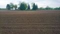
View from the hashpoint
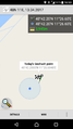
Proof
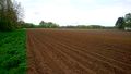
The hashfield
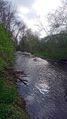
Nearby stream


Achievements
Solli earned the Land geohash achievement
|
Solli earned the Last man standing achievement
|