Difference between revisions of "2017-04-28 48 8"
From Geohashing
imported>Solli |
imported>FippeBot m (Location) |
||
| (4 intermediate revisions by one other user not shown) | |||
| Line 1: | Line 1: | ||
| + | {{meetup graticule | ||
| + | | lat=48 | ||
| + | | lon=8 | ||
| + | | date=2017-04-28 | ||
| + | }} | ||
| + | |||
__NOTOC__ | __NOTOC__ | ||
| Line 14: | Line 20: | ||
== Photos == | == Photos == | ||
| − | |||
<gallery perrow="5"> | <gallery perrow="5"> | ||
| + | Image:2017-04-28 48 8 Solli 01.png | Proof | ||
| + | Image:2017-04-28 48 8 Solli 02.jpg | X marks the spot | ||
| + | Image:2017-04-28 48 8 Solli 03.jpg | View from the hashpoint | ||
| + | Image:2017-04-28 48 8 Solli 04.jpg | Stupid Grin (TM) | ||
</gallery> | </gallery> | ||
| − | |||
| − | |||
== Achievements == | == Achievements == | ||
| − | + | {{#vardefine:ribbonwidth|800px}} | |
| + | {{land geohash | ||
| + | | latitude = 48 | ||
| + | | longitude = 8 | ||
| + | | date = 2017-04-28 | ||
| + | | name = Solli | ||
| + | }} | ||
| + | |||
| + | {{Two to the N achievement | ||
| + | | count = 3 | ||
| + | | date = 2017-04-28 | ||
| + | | latitude = 48 | ||
| + | | longitude = 8 | ||
| + | | name = Solli | ||
| + | | reached = true | ||
| + | | graticule = false | ||
| + | }} | ||
| + | |||
| + | {{Last man standing | ||
| + | | date = 2017-04-28 | ||
| + | | latitude = 48 | ||
| + | | longitude = 8 | ||
| + | | name = Solli | ||
| + | }} | ||
| + | |||
| − | |||
| − | |||
[[Category:Expeditions]] | [[Category:Expeditions]] | ||
[[Category:Expeditions with photos]] | [[Category:Expeditions with photos]] | ||
[[Category:Coordinates reached]] | [[Category:Coordinates reached]] | ||
| − | + | {{location|DE|BW|PF}} | |
Latest revision as of 02:27, 16 August 2019
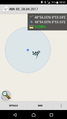
| Fri 28 Apr 2017 in 48,8: 48.9099230, 8.8839253 geohashing.info google osm bing/os kml crox |
Location
On a clearing near Großglattbach
Participants
Plans
No plans.
Expedition
I was in the car on my way from Mannheim to Munich and the traffic was quite heavy. When I got stuck in a traffic jam near Pforzheim I checked the geohashing app if there was anything nearby. And indeed the hashpoint was only 10 km away and appearantly reachable. I left the Highway at Pforzheim East and took some small roads mor or less directly to the hashpoint. There I walked like 100m to the hash, took a screenshot and some photos and took the road back to the Highway. However the road was closed near Serres. Me and my satnav were quite confused, but I managed to find my way back.
Photos
Proof
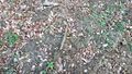
X marks the spot
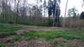
View from the hashpoint

Stupid Grin (TM)


Achievements
Solli earned the Land geohash achievement
|

Solli earned the Two to the N achievement
by reaching 23 hashpoints on 2017-04-28 48 8 and is promoted to Level 3 (Coordinates reached).
Solli earned the Last man standing achievement
|