Difference between revisions of "2017-06-10 52 13"
imported>CamelCase (→Expedition) |
imported>FippeBot m (Location) |
||
| (9 intermediate revisions by 3 users not shown) | |||
| Line 1: | Line 1: | ||
| + | {{Advert}} | ||
<!-- If you did not specify these parameters in the template, please substitute appropriate values for IMAGE, LAT, LON, and DATE (YYYY-MM-DD format) | <!-- If you did not specify these parameters in the template, please substitute appropriate values for IMAGE, LAT, LON, and DATE (YYYY-MM-DD format) | ||
| Line 24: | Line 25: | ||
== Participants == | == Participants == | ||
* [[User:CamelCase|CamelCase]] ([[User talk:CamelCase|talk]]) | * [[User:CamelCase|CamelCase]] ([[User talk:CamelCase|talk]]) | ||
| − | * | + | * [[User:Fleck|Fleck]] ([[User talk:Fleck|talk]]) |
== Expedition == | == Expedition == | ||
| Line 31: | Line 32: | ||
== Tracklog == | == Tracklog == | ||
<!-- if your GPS device keeps a log, you may post a link here --> | <!-- if your GPS device keeps a log, you may post a link here --> | ||
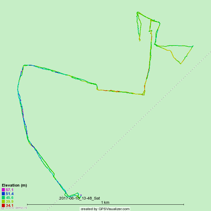
| + | [https://www.openstreetmap.org/user/Alpacacase/traces/2429569 Track on OpenStreetMap] | ||
| + | [[File:2017-06-10_52_13_tracklog.png]] | ||
== Photos == | == Photos == | ||
| Line 42: | Line 45: | ||
{{#vardefine:ribbonwidth|800px}} | {{#vardefine:ribbonwidth|800px}} | ||
<!-- Add any achievement ribbons you earned below, or remove this section --> | <!-- Add any achievement ribbons you earned below, or remove this section --> | ||
| + | {{land geohash | ||
| − | + | | latitude = 52 | |
| − | + | | longitude = 13 | |
| − | + | | date = 2017-06-10 | |
| + | | name = CamelCase and Fleck | ||
| + | }} | ||
| + | {{Two to the N achievement | ||
| − | + | | count = 0 | |
| + | | date = 2017-06-10 | ||
| + | | latitude = 52 | ||
| + | | longitude = 13 | ||
| + | | name = Fleck | ||
| + | | reached = true (optional - include if you are counting coordinates reached) | ||
| − | + | }} | |
| − | + | {{Two to the N achievement | |
| − | + | ||
| − | - | + | | count = 1 |
| + | | date = 2017-06-10 | ||
| + | | latitude = 52 | ||
| + | | longitude = 13 | ||
| + | | name = CamelCase | ||
| + | | reached = true (optional - include if you are counting coordinates reached) | ||
| − | + | }} | |
| − | |||
[[Category:Expeditions]] | [[Category:Expeditions]] | ||
| − | |||
| − | |||
| − | |||
| − | |||
| − | |||
| − | |||
| − | |||
[[Category:Coordinates reached]] | [[Category:Coordinates reached]] | ||
| − | + | {{location|DE|BB|TF}} | |
| − | |||
| − | |||
| − | |||
| − | |||
| − | |||
| − | |||
| − | |||
| − | |||
| − | |||
| − | |||
| − | |||
| − | |||
| − | |||
| − | |||
| − | |||
| − | |||
| − | |||
Latest revision as of 18:30, 26 July 2019
| Have you seen our geohashing marker? We'd love to hear from you! Click here to say "hi" and tell us what you've seen!
Curious about what geohashing is? Read more! |
| Sat 10 Jun 2017 in 52,13: 52.1260623, 13.2006378 geohashing.info google osm bing/os kml crox |
Location
An unused field near a railway track to the south of Berlin.
Participants
Expedition
We met at the railway station Potsdamer Platz and took a train to the south. We changed trains in Luckenwalde, where we went to the local supermarket while waiting for the train which would come in fourty minutes. Woltersdorf/Nuthe-Urstromtal was located about 2 kilometers from the geohash. We walked through the village of Woltersdorf at the border of which the sidewalk ended. We turned onto a track at the side of the Bundesstraße B101 which we followed until it ended. From there we followed the Nuthe river until we encountered a mysterious building and a bridge, which we apparently were not allowed to enter. We reached the geohash in the middle of the field next to that building. We left two of these posters on a nearby bridge.
Tracklog
Photos
Achievements
CamelCase and Fleck earned the Land geohash achievement
|

