Difference between revisions of "2017-06-11 52 13"
From Geohashing
imported>CamelCase (→Participants) |
imported>FippeBot m (Location) |
||
| (19 intermediate revisions by 2 users not shown) | |||
| Line 1: | Line 1: | ||
| + | {{Advert}} | ||
| − | + | [[Image:{{{image|2017-06-11_52_13_Point.jpg}}}|thumb|left]] | |
| − | |||
| − | |||
| − | |||
| − | |||
| − | |||
| − | |||
| − | |||
{{meetup graticule | {{meetup graticule | ||
| lat=52 | | lat=52 | ||
| Line 22: | Line 16: | ||
== Participants == | == Participants == | ||
| − | * CamelCase | + | * [[User:CamelCase|CamelCase]] ([[User talk:CamelCase|talk]]) |
| − | * | + | * [[User:Fleck|Fleck]] ([[User talk:Fleck|talk]]) |
== Plans == | == Plans == | ||
We are going to meet at S Potsdamer Platz at 12:00 at the northernmost end of the platform from which the S1 departs in the direction of S Oranienburg. We will arrive to the geohash at about 13:30. | We are going to meet at S Potsdamer Platz at 12:00 at the northernmost end of the platform from which the S1 departs in the direction of S Oranienburg. We will arrive to the geohash at about 13:30. | ||
| + | * an Anschlussfahrausweis might be useful | ||
| + | * [[User:CamelCase|CamelCase]] ([[User talk:CamelCase|talk]]) is going to bring [http://geo.crox.net/poster/2017-06-11_52_13 posters]. | ||
== Expedition == | == Expedition == | ||
| − | + | We arrived at Borgsdorf station and set out for the point. Soon we left the town and stepped on a forest track. The geohash was only some meters away from said track. We took some pictures, flew a drone, and turned back. | |
== Tracklog == | == Tracklog == | ||
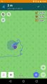
| − | + | [http://www.openstreetmap.org/user/Alpacacase/traces/2430478 OpenStreetMap] | |
| + | [[File:2017-06-11_52_13_track.png]] | ||
== Photos == | == Photos == | ||
| Line 39: | Line 36: | ||
--> | --> | ||
<gallery perrow="5"> | <gallery perrow="5"> | ||
| + | Image:2017-06-11_52_13_time.jpg | the time | ||
| + | Image:2017-06-11_52_13_Station.jpg | the station | ||
| + | Image:2017-06-11_52_13_Borgsdorf.jpg | Borgsdorf station | ||
| + | Image:2017-06-11_52_13_Town.jpg | Borgsdorf | ||
| + | Image:2017-06-11_52_13_Leaving.jpg | leaving Borgsdorf | ||
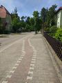
| + | Image:2017-06-11_52_13_Path.jpg | the track | ||
| + | Image:2017-06-11_52_13_Point.jpg | the geohash | ||
| + | Image:2017-06-11_52_13_Proof.jpg | proof | ||
| + | Image:2017-06-11_52_13_Selfie.jpg | more proof | ||
| + | Image:2017-06-11_52_13_Poster.jpg | The internet was here! | ||
</gallery> | </gallery> | ||
| + | |||
| + | == Drone Video == | ||
| + | [https://youtu.be/OlYGilOmaLk Youtube] | ||
== Achievements == | == Achievements == | ||
{{#vardefine:ribbonwidth|800px}} | {{#vardefine:ribbonwidth|800px}} | ||
| − | + | {{consecutive geohash 3 | |
| − | + | | hashcount = 2 | |
| − | + | | daycount = 2 | |
| − | + | | latitude = 52 | |
| + | | longitude = 13 | ||
| + | | date = 2017-06-10 | ||
| + | | name = CamelCase and Fleck | ||
| − | + | }} | |
| + | {{Two to the N achievement | ||
| − | + | | count = 1 | |
| − | + | | date = 2017-06-11 | |
| − | + | | latitude = 52 | |
| − | + | | longitude = 13 | |
| + | | name = Fleck | ||
| + | | reached = true | ||
| − | + | }} | |
| − | |||
[[Category:Expeditions]] | [[Category:Expeditions]] | ||
| − | |||
[[Category:Expeditions with photos]] | [[Category:Expeditions with photos]] | ||
[[Category:Expeditions with videos]] | [[Category:Expeditions with videos]] | ||
| − | + | ||
| − | |||
| − | |||
| − | |||
[[Category:Coordinates reached]] | [[Category:Coordinates reached]] | ||
| − | + | {{location|DE|BB|OHV}} | |
| − | |||
| − | |||
| − | |||
| − | |||
| − | |||
| − | |||
| − | |||
| − | |||
| − | |||
| − | |||
| − | |||
| − | |||
| − | |||
| − | |||
| − | |||
| − | |||
| − | |||
Latest revision as of 02:38, 16 August 2019
| Have you seen our geohashing marker? We'd love to hear from you! Click here to say "hi" and tell us what you've seen!
Curious about what geohashing is? Read more! |

| Sun 11 Jun 2017 in 52,13: 52.7187547, 13.2606454 geohashing.info google osm bing/os kml crox |
Location
Forest.
Participants
Plans
We are going to meet at S Potsdamer Platz at 12:00 at the northernmost end of the platform from which the S1 departs in the direction of S Oranienburg. We will arrive to the geohash at about 13:30.
Expedition
We arrived at Borgsdorf station and set out for the point. Soon we left the town and stepped on a forest track. The geohash was only some meters away from said track. We took some pictures, flew a drone, and turned back.
Tracklog

Photos
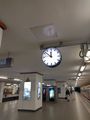
the time
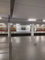
the station
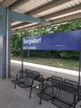
Borgsdorf station
Borgsdorf
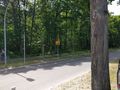
leaving Borgsdorf
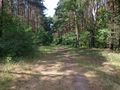
the track
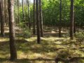
the geohash
proof
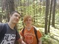
more proof
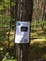
The internet was here!


Drone Video
Achievements
CamelCase and Fleck earned the Consecutive geohash achievement
|

Fleck earned the Two to the N achievement
by reaching 21 hashpoints on 2017-06-11 52 13 and is promoted to Level 1 (Coordinates reached).