Difference between revisions of "2017-06-12 52 13"
imported>CamelCase (→Participants) |
imported>FippeBot m (Location) |
||
| (19 intermediate revisions by 2 users not shown) | |||
| Line 1: | Line 1: | ||
| + | [[Image:{{{image|2017-06-12_52_13_Point.jpg}}}|thumb|left]] | ||
| − | |||
| − | |||
| − | |||
| − | |||
| − | |||
| − | |||
| − | |||
| − | |||
| − | |||
{{meetup graticule | {{meetup graticule | ||
| lat=52 | | lat=52 | ||
| Line 19: | Line 11: | ||
== Location == | == Location == | ||
| − | + | A field near Helenenau. | |
== Participants == | == Participants == | ||
| − | |||
| − | |||
* [[User:CamelCase|CamelCase]] ([[User talk:CamelCase|talk]]) | * [[User:CamelCase|CamelCase]] ([[User talk:CamelCase|talk]]) | ||
| − | * | + | * [[User:Fleck|Fleck]] ([[User talk:Fleck|talk]]) |
== Plans == | == Plans == | ||
| − | + | We are going to meet at the northernmost end of the platform the S2 departs from S Potsdamer Platz in the direction of S Bernau. | |
| + | * Due to weather conditions [[User:CamelCase|CamelCase]] ([[User talk:CamelCase|talk]]) won't be carrying a shoe box. | ||
| + | ETA: 15:00 | ||
| + | You'll need a ticket which will allow you to travel through the Berlin ABC fare zones for two hours in either direction. | ||
== Expedition == | == Expedition == | ||
| − | + | Having arrived at Bernau station we took a bus to a stop near the hash point. We then walked the remaining two kilometers. First the map took us into a strawberry plantation onto a private road not leading anywhere. We returned onto the road we came from and found a way around that plantation, which led us into a horse ranch with no obvious way to reach the hash. Taking a detour through the forest we discovered that the hash point was inside a fenced area. We tried to get as close as we could, without trespassing, took a picture and turned back. On the way back we visited a local Squishy(tm) dealer and bought a Squishy each. They turned out not to taste very squishy. | |
== Tracklog == | == Tracklog == | ||
| − | + | [http://www.openstreetmap.org/user/Alpacacase/traces/2431346 osm] | |
| + | [[File:2017-06-12_52_13_Track.png]] | ||
== Photos == | == Photos == | ||
| − | |||
| − | |||
| − | |||
<gallery perrow="5"> | <gallery perrow="5"> | ||
| + | Image:2017-06-12_52_13_Train.jpg | From the train... | ||
| + | Image:2017-06-12_52_13_Station.jpg | ...to the bus. | ||
| + | Image:2017-06-12_52_13_Bus.jpg | We left the bus. | ||
| + | Image:2017-06-12_52_13_Road.jpg | We walked down the road. | ||
| + | Image:2017-06-12_52_13_Tower.jpg | We walked by a cool communications tower. | ||
| + | Image:2017-06-12_52_13_Turn.jpg | We turned. | ||
| + | Image:2017-06-12_52_13_Wheat.jpg | There was wheat. | ||
| + | Image:2017-06-12_52_13_Private.jpg | Onto a private road. | ||
| + | Image:2017-06-12_52_13_NotOnMap.jpg | That road is now on OSM. | ||
| + | Image:2017-06-12_52_13_Homeopathy.jpg | Smaller sign reads: 'homeopathy for animals' ^^ | ||
| + | Image:2017-06-12_52_13_Forest.jpg | forest track | ||
| + | Image:2017-06-12_52_13_Point.jpg | The hash lies in that direction. | ||
| + | Image:2017-06-12_52_13_Selfie.jpg | proof | ||
| + | Image:2017-06-12_52_13_Proof.jpg | the closest we could get | ||
| + | Image:2017-06-12_52_13_Back.jpg | turning back | ||
| + | Image:2017-06-12_52_13_Dealer.jpg | Squishy(tm) store | ||
| + | Image:2017-06-12_52_13_Squishy.jpg | the not so squishy Squishy(tm) | ||
| + | Image:2017-06-12_52_13_Distance.jpg | just inside the 5km radius | ||
</gallery> | </gallery> | ||
== Achievements == | == Achievements == | ||
{{#vardefine:ribbonwidth|800px}} | {{#vardefine:ribbonwidth|800px}} | ||
| − | + | {{GeoSquishy FirstSip | |
| − | + | | latitude = 52 | |
| − | + | | longitude = 13 | |
| − | + | | date = 2017-06-12 | |
| + | | name = CamelCase and Fleck | ||
| + | | image = 2017-06-12_52_13_Squishy.jpg | ||
| − | + | }} | |
| + | {{Two to the N achievement | ||
| − | + | | count = 2 | |
| − | + | | date = 2017-06-12 | |
| − | + | | latitude = 52 | |
| − | + | | longitude = 13 | |
| + | | name = CamelCase | ||
| − | + | }} | |
| + | {{No trespassing | ||
| + | |||
| + | | latitude = 52 | ||
| + | | longitude = 13 | ||
| + | | date = 2017-06-12 | ||
| + | | name = CamelCase and Fleck | ||
| + | | image = 2017-06-12_52_13_Point.jpg | ||
| + | | distance = 189m | ||
| + | |||
| + | }} | ||
| − | |||
[[Category:Expeditions]] | [[Category:Expeditions]] | ||
| − | |||
[[Category:Expeditions with photos]] | [[Category:Expeditions with photos]] | ||
| − | |||
| − | |||
| − | |||
| − | |||
| − | |||
| − | |||
| − | |||
| − | |||
[[Category:Coordinates not reached]] | [[Category:Coordinates not reached]] | ||
| − | |||
| − | |||
| − | |||
| − | |||
| − | |||
[[Category:Not reached - No public access]] | [[Category:Not reached - No public access]] | ||
| − | + | {{location|DE|BB|BAR}} | |
| − | |||
| − | |||
| − | |||
| − | |||
| − | |||
| − | |||
| − | |||
Latest revision as of 02:38, 16 August 2019

| Mon 12 Jun 2017 in 52,13: 52.6389378, 13.6409199 geohashing.info google osm bing/os kml crox |
Location
A field near Helenenau.
Participants
Plans
We are going to meet at the northernmost end of the platform the S2 departs from S Potsdamer Platz in the direction of S Bernau.
ETA: 15:00 You'll need a ticket which will allow you to travel through the Berlin ABC fare zones for two hours in either direction.
Expedition
Having arrived at Bernau station we took a bus to a stop near the hash point. We then walked the remaining two kilometers. First the map took us into a strawberry plantation onto a private road not leading anywhere. We returned onto the road we came from and found a way around that plantation, which led us into a horse ranch with no obvious way to reach the hash. Taking a detour through the forest we discovered that the hash point was inside a fenced area. We tried to get as close as we could, without trespassing, took a picture and turned back. On the way back we visited a local Squishy(tm) dealer and bought a Squishy each. They turned out not to taste very squishy.
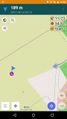
Tracklog

Photos
From the train...
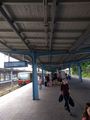
...to the bus.
We left the bus.
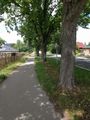
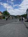
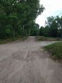
We walked down the road.
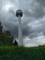
We walked by a cool communications tower.
We turned.
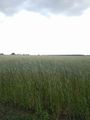
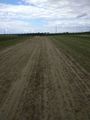
There was wheat.
Onto a private road.
That road is now on OSM.
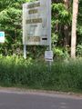
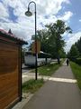
Smaller sign reads: 'homeopathy for animals' ^^
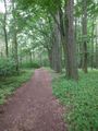
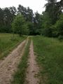
forest track
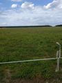
The hash lies in that direction.
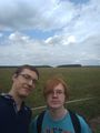
proof
the closest we could get
turning back
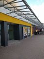
Squishy(tm) store
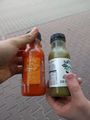
the not so squishy Squishy(tm)
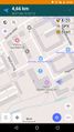
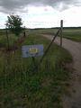
just inside the 5km radius


Achievements
CamelCase and Fleck earned the First Sip GeoSquishy Achievement
|

CamelCase and Fleck earned the No trespassing consolation prize
|