Difference between revisions of "2017-09-09 43 -79"
imported>Frogman ([live picture]Boardwalk) |
m (More specific location) |
||
| (7 intermediate revisions by 2 users not shown) | |||
| Line 1: | Line 1: | ||
| − | |||
| − | |||
| − | |||
| − | |||
| − | |||
| − | |||
| − | |||
| − | |||
| − | |||
| − | |||
{{meetup graticule | {{meetup graticule | ||
| lat=43 | | lat=43 | ||
| Line 19: | Line 9: | ||
== Location == | == Location == | ||
| − | + | In a forested area near the West branch of the Don River in North York. | |
== Participants == | == Participants == | ||
<!-- who attended: If you link to your wiki user name in this section, your expedition will be picked up by the various statistics generated for geohashing. You may use three tildes ~ as a shortcut to automatically insert the user signature of the account you are editing with. | <!-- who attended: If you link to your wiki user name in this section, your expedition will be picked up by the various statistics generated for geohashing. You may use three tildes ~ as a shortcut to automatically insert the user signature of the account you are editing with. | ||
--> | --> | ||
| + | * [[User:Frogman|Frogman]] | ||
== Plans == | == Plans == | ||
<!-- what were the original plans --> | <!-- what were the original plans --> | ||
| + | This looked like it was walking distance from where I'm staying temporarily. | ||
== Expedition == | == Expedition == | ||
<!-- how it all turned out. your narrative goes here. --> | <!-- how it all turned out. your narrative goes here. --> | ||
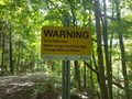
| + | Google suggested approaching the hashpoint from the north, crossing the river at a bridge. It took me about twenty minutes to walk to the general vicinity of the bridge, and then another twenty to actually find it, because there were FAR more trails than Google knew about, and none of them were marked. Finally, I reached the bridge, but it was blocked with a fence and a notice prohibiting entry. | ||
| + | Some less intrepid geohashers may have given up here, but not me! I noticed that on the other side of the river there was another trail into the forested area. I walked around via Wilmington Avenue and entered from this other trail. The hashpoint was accessible from this side! I only had to bushwhack a bit, crawling about a meter to get within GPS margin-of-error. As I occasionally do, I forgot to take a goofy grin picture. To be fair, I was already about two hours into what I thought would be an hour walk, and a bit exhausted. | ||
| − | + | It turns out that the hashpoint was near a Toronto School District outdoor learning area, which explained the bridge closure. Luckily, no one was there -- I wouldn't want to disturb any events going on. | |
| − | + | ||
| − | + | A nice first [[Toronto, Ontario]] geohash! | |
== Photos == | == Photos == | ||
| Line 51: | Line 45: | ||
Image:2017-09-09_43_-79_frogman_1504987472356.jpg|Boardwalk | Image:2017-09-09_43_-79_frogman_1504987472356.jpg|Boardwalk | ||
| − | |||
| − | + | Image:2017-09-09_43_-79_frogman_1504987487487.jpg|West Don River | |
| − | |||
| − | |||
| − | + | Image:2017-09-09_43_-79_frogman_1504987516066.jpg|Field, with hashpoint in those bushes back there. | |
| − | |||
| − | |||
| − | + | Image:2017-09-09_43_-79_frogman_1504987527818.jpg|Made it! | |
| − | + | Image:2017-09-09_43_-79_frogman_1504987552557.jpg|You can sort of see the field through here. | |
| − | |||
| − | |||
| − | |||
| − | + | Image:2017-09-09_43_-79_frogman_1504987572808.jpg|Had to crawl under this to get to the hashpoint! | |
| + | </gallery> | ||
| − | |||
[[Category:Expeditions]] | [[Category:Expeditions]] | ||
| − | |||
[[Category:Expeditions with photos]] | [[Category:Expeditions with photos]] | ||
| − | |||
| − | |||
| − | |||
| − | |||
| − | |||
[[Category:Coordinates reached]] | [[Category:Coordinates reached]] | ||
| − | + | {{location|CA|ON|TO}} | |
| − | |||
| − | |||
| − | |||
| − | |||
| − | |||
| − | |||
| − | |||
| − | |||
| − | |||
| − | |||
| − | |||
| − | |||
| − | |||
| − | |||
| − | |||
| − | |||
| − | |||
Latest revision as of 00:13, 10 August 2020
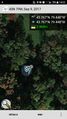
| Sat 9 Sep 2017 in 43,-79: 43.7673287, -79.4481947 geohashing.info google osm bing/os kml crox |
Location
In a forested area near the West branch of the Don River in North York.
Participants
Plans
This looked like it was walking distance from where I'm staying temporarily.
Expedition
Google suggested approaching the hashpoint from the north, crossing the river at a bridge. It took me about twenty minutes to walk to the general vicinity of the bridge, and then another twenty to actually find it, because there were FAR more trails than Google knew about, and none of them were marked. Finally, I reached the bridge, but it was blocked with a fence and a notice prohibiting entry.
Some less intrepid geohashers may have given up here, but not me! I noticed that on the other side of the river there was another trail into the forested area. I walked around via Wilmington Avenue and entered from this other trail. The hashpoint was accessible from this side! I only had to bushwhack a bit, crawling about a meter to get within GPS margin-of-error. As I occasionally do, I forgot to take a goofy grin picture. To be fair, I was already about two hours into what I thought would be an hour walk, and a bit exhausted.
It turns out that the hashpoint was near a Toronto School District outdoor learning area, which explained the bridge closure. Luckily, no one was there -- I wouldn't want to disturb any events going on.
A nice first Toronto, Ontario geohash!
Photos
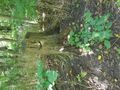
Dam upstream!
Happy stump.
Here's the bridge...
...but it's not accessible!
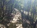
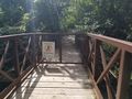
Boardwalk
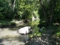
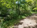
West Don River
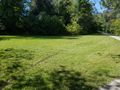
Field, with hashpoint in those bushes back there.
Made it!
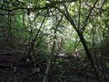
You can sort of see the field through here.
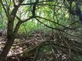
Had to crawl under this to get to the hashpoint!


