Difference between revisions of "2017-09-14 31 35"
m (Location) |
m |
||
| Line 63: | Line 63: | ||
<!-- Add any achievement ribbons you earned below, or remove this section --> | <!-- Add any achievement ribbons you earned below, or remove this section --> | ||
| − | + | [[Category:Expeditions]] | |
| − | |||
| − | |||
| − | |||
| − | |||
| − | |||
| − | |||
| − | |||
| − | |||
| − | |||
| − | |||
[[Category:Expeditions with photos]] | [[Category:Expeditions with photos]] | ||
| − | |||
| − | |||
| − | |||
| − | |||
| − | |||
| − | |||
| − | |||
| − | |||
[[Category:Coordinates reached]] | [[Category:Coordinates reached]] | ||
| − | |||
| − | |||
| − | |||
| − | |||
| − | |||
| − | |||
| − | |||
| − | |||
| − | |||
| − | |||
| − | |||
| − | |||
| − | |||
| − | |||
| − | |||
| − | |||
| − | |||
| − | |||
| − | |||
| − | |||
{{location|IL|YS}} | {{location|IL|YS}} | ||
Latest revision as of 12:25, 23 September 2021
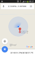
| Thu 14 Sep 2017 in 31,35: 31.8197840, 35.5076870 geohashing.info google osm bing/os kml crox |
Location
Beit Hoglah, West Bank, Israel. Lowest hash ever.
Participants
Plans
The 961 bus leaves on Thursday morning at 7:00. Maybe I'll get lucky and someone else will be on it?
Expedition
The bus traveled as planned. I got off, and went east towards the army base. I alerted the guard there that I was going to go on a short hike to the southeast. She seemed fine with that. I walked into Beit Hoglah which had a group of abandoned houses at the entrance. It looks like there are less than fifty people living there with many more date palm trees. I crossed the wadi which was dry but full of plants and climbed along some small sand banks until I reached the hash point. By looking at amudanan.co.il, the hashpoint looks like it's around -337 meters, but the powers that be can debate on what it really is. On the way back I did a lap around Beit Hoglah to see if there was anything interesting there and returned to the bus station. The town ended up being fenced, so I didn't go inside. It probably is too small to appear on a map so I'll need to find a better name for the area.
Future plans for lowest hashpoint
It looks like the lowest hashpoint is going to be stay in the region unless someone decides to dig a hole or do an insane scuba dive or submarine hash. The Jordan River/Dead Sea depression is the deepest in the world, and the only way to reach it is to go to either Jordan or Israel. The Dead Sea is about 415 meters below sea level so that will likely be where it will stop. By the way, if you're wondering where the name "West Bank" came from, it refers to the west bank of the Jordan River which is a large part of the Israeli/Jordanian border.
In other news it looks like tomorrow's: 2017-09-14 31 35 will be at -364 meters. I won't go because I think it's a closed military zone, and I'll be busy.
Photos
Proof
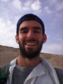
The hill is behind me


Achievements
Yosef earned the Lowest Geohash Achievement
|